File:Aegean Sea map bathymetry-fr.svg
Jump to navigation
Jump to search

Size of this PNG preview of this SVG file: 493 × 599 pixels. Other resolutions: 197 × 240 pixels | 395 × 480 pixels | 631 × 768 pixels | 842 × 1,024 pixels | 1,684 × 2,048 pixels | 3,750 × 4,560 pixels.
Original file (SVG file, nominally 3,750 × 4,560 pixels, file size: 3.57 MB)
Captions
Captions
Add a one-line explanation of what this file represents
Summary
[edit]| Camera location | | View this and other nearby images on: OpenStreetMap |
|---|
| Description |
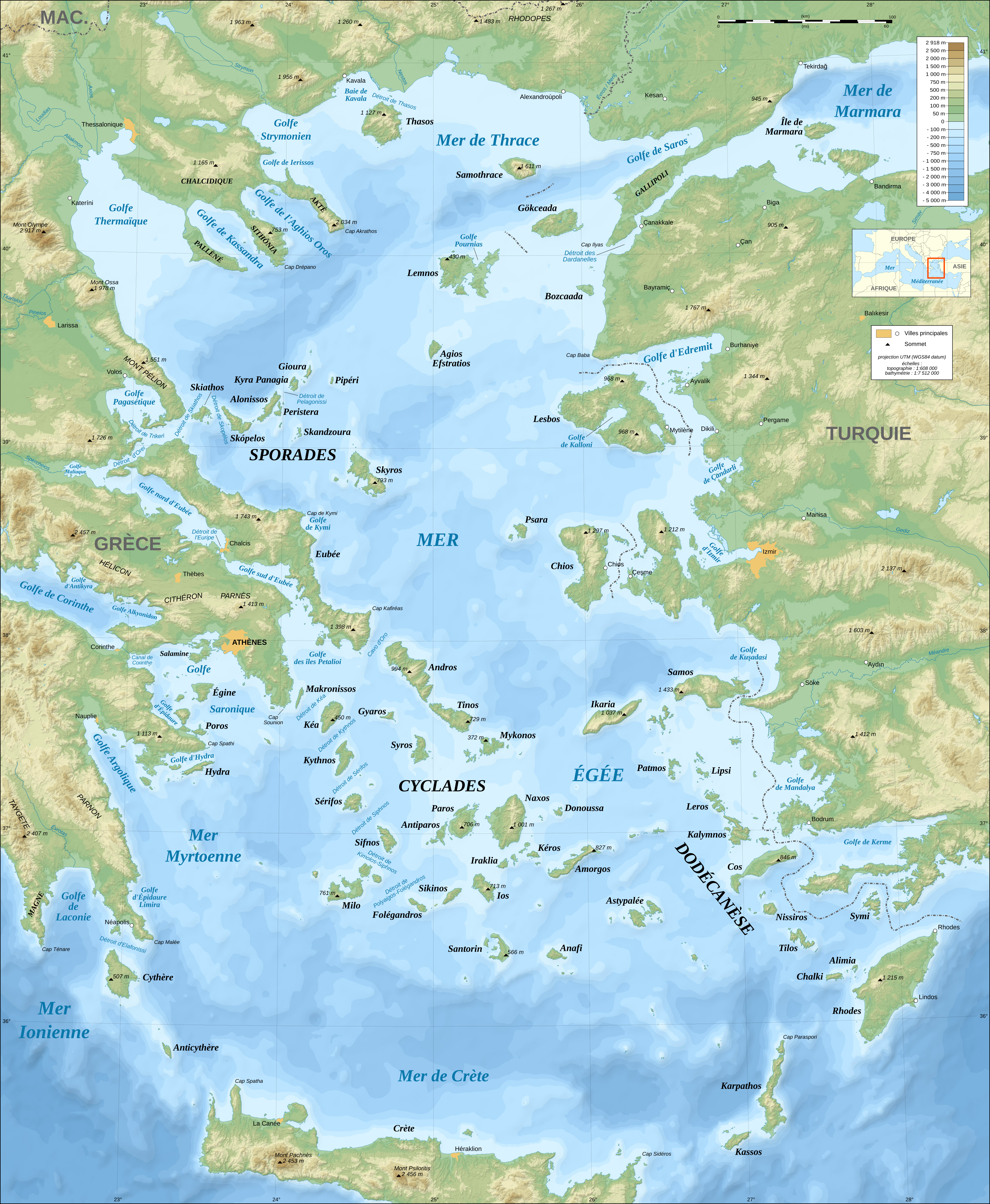
English: Bathymetric map in French of the Aegean Sea, Mediterranean Sea.
Note: The background map is a raster image embedded in the SVG file. Français : Carte bathymétrique en français de la Mer Égée, Mer Méditerranée.
Note : Le fond de carte est une image bitmap embarquée dans le fichier SVG.
|
||
| Date | November 2007 (modified September 2008) | ||
| Source |
Own work (Original text: Own work ;)
|
||
| Author | Eric Gaba (Sting - fr:Sting) | ||
| Permission (Reusing this file) |
|
||
| Other versions |
[]
Same map but full SVG and without relief and bathymetry:
Derivative works of this file: |
||
| SVG development |


Licensing
[edit]

|
Permission is granted to copy, distribute and/or modify this document under the terms of the GNU Free Documentation License, Version 1.2 or any later version published by the Free Software Foundation; with no Invariant Sections, no Front-Cover Texts, and no Back-Cover Texts. A copy of the license is included in the section entitled GNU Free Documentation License. |
This file is licensed under the Creative Commons Attribution-Share Alike 4.0 International, 3.0 Unported, 2.5 Generic, 2.0 Generic and 1.0 Generic license.
- You are free:
- to share – to copy, distribute and transmit the work
- to remix – to adapt the work
- Under the following conditions:
- attribution – You must give appropriate credit, provide a link to the license, and indicate if changes were made. You may do so in any reasonable manner, but not in any way that suggests the licensor endorses you or your use.
- share alike – If you remix, transform, or build upon the material, you must distribute your contributions under the same or compatible license as the original.
You may select the license of your choice.
File history
Click on a date/time to view the file as it appeared at that time.
| Date/Time | Thumbnail | Dimensions | User | Comment | |
|---|---|---|---|---|---|
| current | 22:03, 17 July 2010 | | 3,750 × 4,560 (3.57 MB) | Sting (talk | contribs) | Color profile |
| 00:35, 8 February 2009 |  | 3,750 × 4,560 (3.43 MB) | Sting (talk | contribs) | Correcting display bug - new try - step #2 | |
| 00:29, 8 February 2009 |  | 3,750 × 4,560 (401 KB) | Sting (talk | contribs) | Correcting display bug - new try - step #1 | |
| 00:14, 8 February 2009 |  | 3,750 × 4,560 (3.57 MB) | Sting (talk | contribs) | Correcting display bug | |
| 07:54, 6 February 2009 |  | 3,750 × 4,560 (3.57 MB) | Future Perfect at Sunrise (talk | contribs) | null edit, re-uploading to try to force display to be reset, background image wasn't displaying | |
| 07:52, 6 February 2009 |  | 3,750 × 4,560 (3.57 MB) | Future Perfect at Sunrise (talk | contribs) | null edit, re-uploading to try to force display to be reset, background image wasn't displaying | |
| 21:11, 28 September 2008 |  | 3,750 × 4,560 (3.57 MB) | Sting (talk | contribs) | Completely new background using ETOPO1 data ; new standard colors ; some additional labels | |
| 13:16, 27 November 2007 |  | 3,750 × 4,560 (3.89 MB) | Sting (talk | contribs) | Elevation on Chios | |
| 23:25, 26 November 2007 |  | 3,750 × 4,560 (3.89 MB) | Sting (talk | contribs) | correction | |
| 22:42, 21 November 2007 |  | 3,750 × 4,560 (3.89 MB) | Sting (talk | contribs) | Additional sea names |
You cannot overwrite this file.
File usage on Commons
The following 17 pages use this file:
- Commons:Village pump/Archive/2009/02
- File:Aegean Sea map-de.png
- File:Aegean Sea map-de.svg
- File:Aegean Sea map-fr.svg
- File:Aegean Sea map-it.svg
- File:Aegean Sea map bathymetry-es.svg
- File:Aegean Sea map bathymetry-fi.svg
- File:Aegean Sea map bathymetry-fr.jpg
- File:Aegean Sea map bathymetry-fr.svg
- File:Aegean Sea map bathymetry-it.svg
- File:Aegean Sea map bathymetry-tr.svg
- File:Aegean Sea map bathymetry.svg
- File:Ionian Revolt Campaign Map.png
- File:Jonski ustanak-sh-Ionian-Revolt.svg
- File:Thermopylae & Artemisium campaign map.png
- Template:Other versions/Aegean Sea map bathymetry
- Category:Myrtoan Sea
File usage on other wikis
The following other wikis use this file:
- Usage on de.wikipedia.org
- Usage on fr.wikipedia.org
- Usage on la.wikipedia.org
- Usage on www.wikidata.org