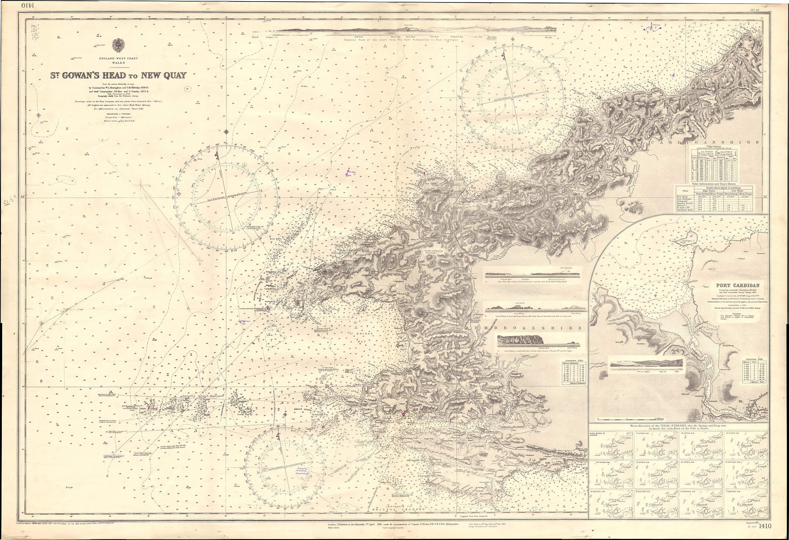
File:Admiralty Chart No 1410 St Gowan's Head to New Quay, Published 1881.jpg
Jump to navigation
Jump to search

Size of this preview: 800 × 548 pixels. Other resolutions: 320 × 219 pixels | 640 × 439 pixels | 1,024 × 702 pixels | 1,280 × 877 pixels | 2,560 × 1,754 pixels | 16,195 × 11,098 pixels.
Original file (16,195 × 11,098 pixels, file size: 12.75 MB, MIME type: image/jpeg)
Captions
Captions
Add a one-line explanation of what this file represents
Summary
[edit]
| Warning | The original file is very high-resolution. It might not load properly or could cause your browser to freeze when opened at full size. |
|---|
Mercator projection
Licensing
[edit]
This work created by the United Kingdom Government is in the public domain.
This is because it is one of the following:
HMSO has declared that the expiry of Crown Copyrights applies worldwide (ref: HMSO Email Reply)
|
 |
File history
Click on a date/time to view the file as it appeared at that time.
| Date/Time | Thumbnail | Dimensions | User | Comment | |
|---|---|---|---|---|---|
| current | 18:40, 30 June 2018 | | 16,195 × 11,098 (12.75 MB) | Kognos (talk | contribs) | User created page with UploadWizard |
You cannot overwrite this file.
File usage on Commons
There are no pages that use this file.
Categories:
- Admiralty Charts 1401-1600
- Admiralty Charts Region B: England Wales Ireland English Channel southern North Sea
- St David's Head
- Maps of Pembrokeshire
- Cardigan, Ceredigion
- 1881 maps of Europe
- 1880s maps of Wales
- Pembrokeshire in the 1880s
- William Louis Sheringham
- The Smalls, Pembrokeshire
- George Manley Alldridge