File:AchkarrenTopografic.jpg
Jump to navigation
Jump to search
No higher resolution available.
AchkarrenTopografic.jpg (268 × 268 pixels, file size: 29 KB, MIME type: image/jpeg)
Captions
Captions
Add a one-line explanation of what this file represents
| Description |
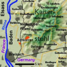
English: Location of Achkarren in a totografic view of the Kaiserstuhl |
| Date | |
| Source | Modified version of Kaiserstuhl-topographie.png |
| Author | Modified by Kiu77 |
Summary
[edit]
Part of a topographic map of the Kaiserstuhl located in the south west corner of w:Germany. Created with Overlays and projected to a detail of DEM suedlicher-oberrhein.jpg, added names of towns for English Wikipedia.
The town of w:Achkarren and the small industrial park ist marked red. Th w:Burg Hoehingen (a castle) is marked with narrow font.
A free version of the map without ton names can be found at Kaiserstuhl-topographie.png for use in the Wikipedias with other languages.
Licensing
[edit]
I, the copyright holder of this work, hereby publish it under the following license:

|
Permission is granted to copy, distribute and/or modify this document under the terms of the GNU Free Documentation License, Version 1.2 or any later version published by the Free Software Foundation; with no Invariant Sections, no Front-Cover Texts, and no Back-Cover Texts. A copy of the license is included in the section entitled GNU Free Documentation License. |
| This file is licensed under the Creative Commons Attribution-Share Alike 3.0 Unported license. | ||
| ||
| This licensing tag was added to this file as part of the GFDL licensing update. |
File history
Click on a date/time to view the file as it appeared at that time.
| Date/Time | Thumbnail | Dimensions | User | Comment | |
|---|---|---|---|---|---|
| current | 10:17, 9 September 2007 | | 268 × 268 (29 KB) | Kiu77 (talk | contribs) | == Summary == Part of a topographic map of the Kaiserstuhl located in the sout west corner of Germany. Created with Overlays and projected to a detail of DEM suedlicher-oberrhein.jpg, added names of towns fo |
You cannot overwrite this file.
File usage on Commons
There are no pages that use this file.
File usage on other wikis
The following other wikis use this file:
- Usage on en.wikipedia.org