File:Aberdeen, city skyline - geograph.org.uk - 598124.jpg
Jump to navigation
Jump to search
No higher resolution available.
Aberdeen,_city_skyline_-_geograph.org.uk_-_598124.jpg (640 × 369 pixels, file size: 47 KB, MIME type: image/jpeg)
Captions
Captions
Add a one-line explanation of what this file represents
Summary
[edit]
| Description |
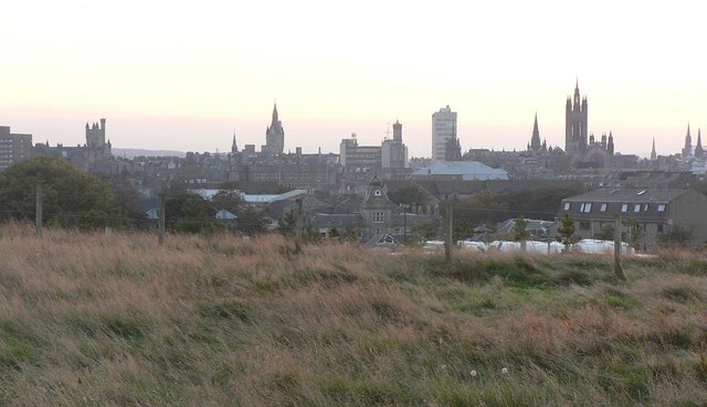
English: Aberdeen: city skyline A view over the rooftops of central Aberdeen. The principal buildings are:
About ⅛ from the left, the Citadel by the Mercat Cross (see 481283); About ⅓ from the left, the clock tower of the 481280; About ⅝ from the left, the 598065; Partially obscured by tower block, a tower of 598071; About ¾ from the left, the spire of 598079; Finally, the tallest building far right, the main tower of Marischal College (see 305815). |
| Date | |
| Source | From geograph.org.uk |
| Author | Chris Downer |
| Attribution (required by the license) | Chris Downer / Aberdeen: city skyline / |
| Camera location | | View this and other nearby images on: OpenStreetMap |
|---|
_heading:225.00&language=en)
| Object location | | View this and other nearby images on: OpenStreetMap |
|---|
_heading:225.00&language=en)
Licensing
[edit]

|
This image was taken from the Geograph project collection. See this photograph's page on the Geograph website for the photographer's contact details. The copyright on this image is owned by Chris Downer and is licensed for reuse under the Creative Commons Attribution-ShareAlike 2.0 license.
|
This file is licensed under the Creative Commons Attribution-Share Alike 2.0 Generic license.
Attribution: Chris Downer
- You are free:
- to share – to copy, distribute and transmit the work
- to remix – to adapt the work
- Under the following conditions:
- attribution – You must give appropriate credit, provide a link to the license, and indicate if changes were made. You may do so in any reasonable manner, but not in any way that suggests the licensor endorses you or your use.
- share alike – If you remix, transform, or build upon the material, you must distribute your contributions under the same or compatible license as the original.
File history
Click on a date/time to view the file as it appeared at that time.
| Date/Time | Thumbnail | Dimensions | User | Comment | |
|---|---|---|---|---|---|
| current | 16:54, 6 February 2011 | | 640 × 369 (47 KB) | GeographBot (talk | contribs) | == {{int:filedesc}} == {{Information |description={{en|1=Aberdeen: city skyline A view over the rooftops of central Aberdeen. The principal buildings are: About ⅛ from the left, the Citadel by the Mercat Cross (see 481283); About ⅓ from |
You cannot overwrite this file.
File usage on Commons
The following page uses this file: