File:A plan of Alfred, Maine LOC 2013593116.jpg
Jump to navigation
Jump to search

Size of this preview: 800 × 452 pixels. Other resolutions: 320 × 181 pixels | 640 × 362 pixels | 1,024 × 579 pixels | 1,280 × 723 pixels | 2,560 × 1,447 pixels | 11,754 × 6,642 pixels.
Original file (11,754 × 6,642 pixels, file size: 8.06 MB, MIME type: image/jpeg)
Captions
Captions
Add a one-line explanation of what this file represents
Summary
[edit]| Description |
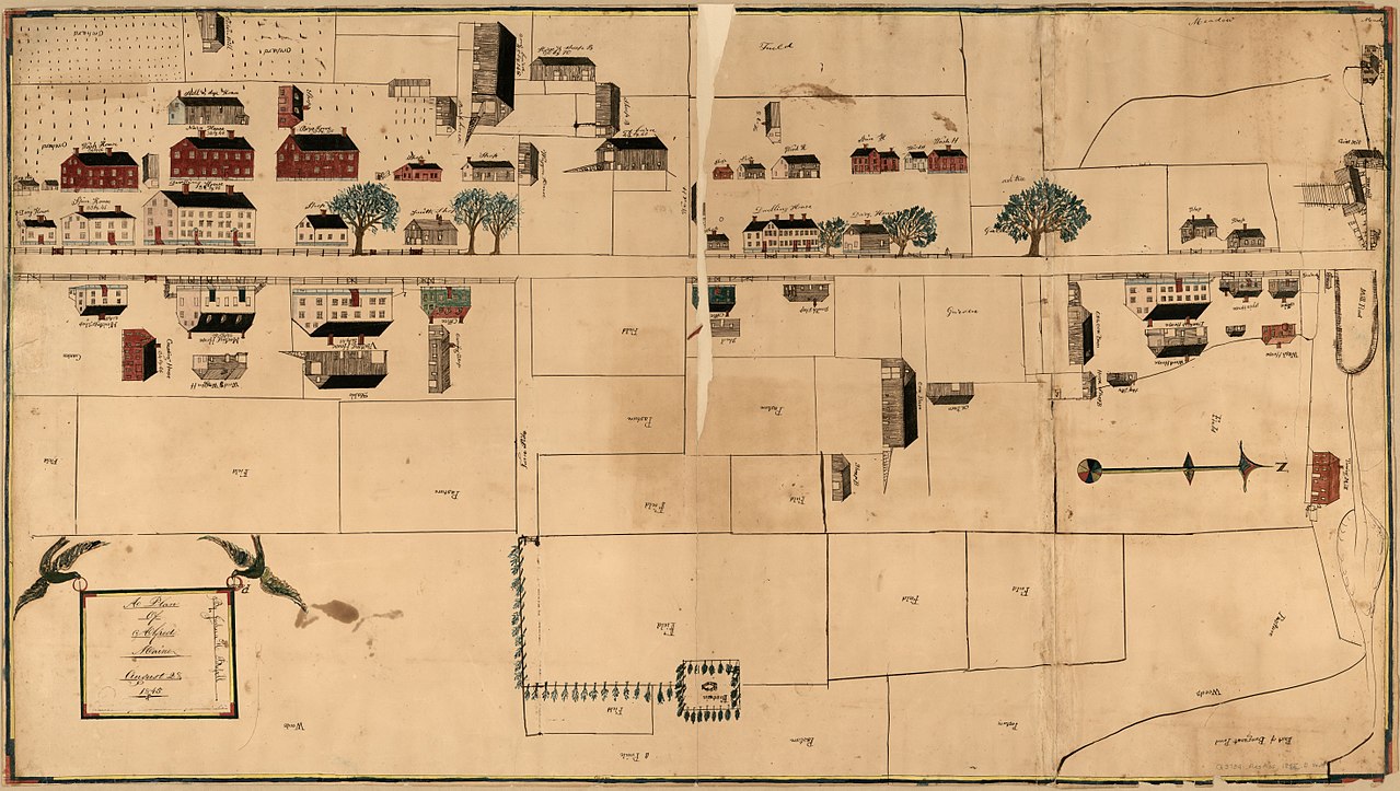
English: Shows buildings pictorially. Pen-and-ink and watercolor. Oriented with north to the right. Folded vertically, with losses in the upper half. Profiles on verso: The hill east & west -- The hill north & south -- Shape of the road from one bridge to the other. Accompanying drawing shows three Shaker buildings, annotated, probably incorrectly, in pencil in lower margin as: 1. Hancock Mass. ; 2. Mt. Lebanon, South family, NY. ; 3. Mt. Lebanon, NY., Shaker meeting house. Available also through the Library of Congress Web site as a raster image. |
||
| Title | A plan of Alfred, Maine | ||
| Shelf ID | G3734.A432 1845 .B8 | ||
| Date | |||
| Source | https://www.loc.gov/item/2013593116/ | ||
| Author | Bussell, Joshua H. | ||
| Permission (Reusing this file) |
|
||
| Other versions |
|
||
| Location | Alfred (Town) · United States · Town · Maine · Alfred | ||
| Part of | American Memory · Cities And Towns · Catalog · Geography And Map Division | ||
| Subject | Alfred (Town) · Alfred (Me. : Town) · Pictorial Maps · Shaker Architecture · United States · Maps · Manuscript Maps · Alfred · Maine · Pictorial Works |


Licensing
[edit]
|
This is a faithful photographic reproduction of a two-dimensional, public domain work of art. The work of art itself is in the public domain for the following reason:
The official position taken by the Wikimedia Foundation is that "faithful reproductions of two-dimensional public domain works of art are public domain".
This photographic reproduction is therefore also considered to be in the public domain in the United States. In other jurisdictions, re-use of this content may be restricted; see Reuse of PD-Art photographs for details. | ||||
File history
Click on a date/time to view the file as it appeared at that time.
| Date/Time | Thumbnail | Dimensions | User | Comment | |
|---|---|---|---|---|---|
| current | 11:23, 21 May 2018 | | 11,754 × 6,642 (8.06 MB) | Fæ (talk | contribs) | LOC Maps https://www.loc.gov/item/2013593116/ #778 |
You cannot overwrite this file.
File usage on Commons
The following 2 pages use this file: