File:A new map of South Carolina with its canals, roads & distances from place to place along the stage & steam boat routes. LOC 98688556.tif
Jump to navigation
Jump to search

Size of this JPG preview of this TIF file: 731 × 600 pixels. Other resolutions: 293 × 240 pixels | 585 × 480 pixels | 936 × 768 pixels | 1,248 × 1,024 pixels | 2,497 × 2,048 pixels | 4,496 × 3,688 pixels.
Original file (4,496 × 3,688 pixels, file size: 47.44 MB, MIME type: image/tiff)
Captions
Captions
Add a one-line explanation of what this file represents
Summary
[edit]| Description |
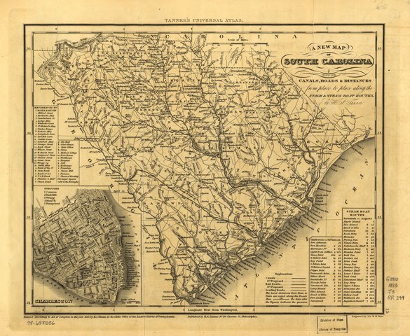
English: The earliest general map to show the South Carolina Canal and Rail Road Company's line which began in Charleston, S.C. It was completed to Hamburg, S.C., in 1833. Its 136 miles of track were then the longest in the world. |
||
| Title | A new map of South Carolina with its canals, roads & distances from place to place along the stage & steam boat routes. | ||
| Shelf ID | G3910 1833 .T3 | ||
| Date | |||
| Source | https://www.loc.gov/item/98688556/ | ||
| Author | Tanner, Henry Schenck; South Carolina Canal And Railroad Company | ||
| Permission (Reusing this file) |
|
||
| Other versions |
|
||
| Location | South Carolina · United States | ||
| Part of | American Memory · Catalog · Railroad Maps, 1828-1900 · Geography And Map Division · Transportation And Communication | ||
| Subject | South Carolina · Maps · United States · South Carolina Canal And Railroad Company |


Licensing
[edit]|
This is a faithful photographic reproduction of a two-dimensional, public domain work of art. The work of art itself is in the public domain for the following reason:
The official position taken by the Wikimedia Foundation is that "faithful reproductions of two-dimensional public domain works of art are public domain".
This photographic reproduction is therefore also considered to be in the public domain in the United States. In other jurisdictions, re-use of this content may be restricted; see Reuse of PD-Art photographs for details. | ||||
File history
Click on a date/time to view the file as it appeared at that time.
| Date/Time | Thumbnail | Dimensions | User | Comment | |
|---|---|---|---|---|---|
| current | 17:54, 23 May 2018 |  | 4,496 × 3,688 (47.44 MB) | Fæ (talk | contribs) | LOC Maps https://www.loc.gov/item/98688556/ #146 |
You cannot overwrite this file.
File usage on Commons
The following page uses this file: