File:A new map of North America - with the British, French, Spanish, Dutch & Danish dominions on that great continent, and the West India Islands, according to the definitive treaty concluded at Paris 10th NYPL434522.tiff
Jump to navigation
Jump to search

Size of this JPG preview of this TIF file: 800 × 525 pixels. Other resolutions: 320 × 210 pixels | 640 × 420 pixels | 1,024 × 672 pixels | 1,280 × 840 pixels | 2,560 × 1,680 pixels | 5,803 × 3,808 pixels.
Original file (5,803 × 3,808 pixels, file size: 63.23 MB, MIME type: image/tiff)
Captions
Captions
Add a one-line explanation of what this file represents
Summary
[edit]| Description | A new map of North America : with the British, French, Spanish, Dutch & Danish dominions on that great continent, and the West India Islands, according to the definitive treaty concluded at Paris 10th February 1763 / with great improvements from the Sieurs d'Anville & Robert. | |||||||||||||||||||||||
| Notes | Includes historical notes, treaty extracts, prevailing wind directions, 10 insets of harbors, and a table showing that "North America is divided into the continent & the islands" according to geography and politics. Note 2.) Lawrence H. Slaughter Collection ; 735. Note 3.) National Endowment for the Humanities Grant for Access to Early Maps of the Middle Atlantic Seaboard. Note 4.) Relief shown pictorially. | |||||||||||||||||||||||
| Physical description | 1 map : hand col. ; 57 x 95 cm. | |||||||||||||||||||||||
| Catalog Call Number | Map Div. 97-6410 [LHS 735] | |||||||||||||||||||||||
| Date | circa 1763 | |||||||||||||||||||||||
| Source |
http://digitalgallery.nypl.org/nypldigital/dgkeysearchdetail.cfm?imageID=434522
|
|||||||||||||||||||||||
| Author | Sayer, Robert, 1725-1794 -- Cartographer ;Anville, Jean Baptiste Bourguignon d', 1697-1782 -- CartographerRobert de Vaugondy, Didier, 1723-1786 -- Cartographer | |||||||||||||||||||||||
| Permission (Reusing this file) |
From The Lionel Pincus & Princess Firyal Map Division. Released on a CC0 license.[1] | |||||||||||||||||||||||
| Digital ID | 434522 | |||||||||||||||||||||||
| Location | Stephen A. Schwarzman Building / The Lionel Pincus and Princess Firyal Map Division | |||||||||||||||||||||||
| NYPL digital item published | 2-3-2004; updated 3-25-2011 | |||||||||||||||||||||||

Licensing
[edit]| This file is made available under the Creative Commons CC0 1.0 Universal Public Domain Dedication. | |
| The person who associated a work with this deed has dedicated the work to the public domain by waiving all of their rights to the work worldwide under copyright law, including all related and neighboring rights, to the extent allowed by law. You can copy, modify, distribute and perform the work, even for commercial purposes, all without asking permission.
|
The making of this file was supported by Wikimedia UK.
To see other files made with the support of Wikimedia UK, please see the category Supported by Wikimedia UK.
|
File history
Click on a date/time to view the file as it appeared at that time.
| Date/Time | Thumbnail | Dimensions | User | Comment | |
|---|---|---|---|---|---|
| current | 09:31, 19 January 2023 |  | 5,803 × 3,808 (63.23 MB) | Sebastian Wallroth (talk | contribs) | rotated 180° using CropTool with lossless mode. |
| 09:31, 19 January 2023 |  | 5,803 × 3,808 (63.23 MB) | Sebastian Wallroth (talk | contribs) | rotated 90° using CropTool with lossless mode. | |
| 02:38, 8 April 2014 | 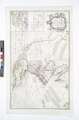 | 3,808 × 5,803 (63.23 MB) | Fæ (talk | contribs) | =={{int:filedesc}}== {{NYPL_map |digital_id = 434522 |creators = Sayer, Robert, 1725-1794 -- Cartographer ;Anville, Jean Baptiste Bourguignon d', 1697-1782 -- Cartographer |record_id = 253142 |catalog_call_number = Map Div. 97-6410 [LHS 735] |item_phy... |
You cannot overwrite this file.
File usage on Commons
There are no pages that use this file.