File:A map of the second section of that part of Georgia now known as the Cherokee Territory in which are delineated all the districts & lots which by an act of the General Assembly were designated the LOC 82690523.tif
Jump to navigation
Jump to search

Size of this JPG preview of this TIF file: 379 × 600 pixels. Other resolutions: 152 × 240 pixels | 303 × 480 pixels | 485 × 768 pixels | 647 × 1,024 pixels | 1,294 × 2,048 pixels | 7,655 × 12,112 pixels.
Original file (7,655 × 12,112 pixels, file size: 265.27 MB, MIME type: image/tiff)
Captions
Captions
Add a one-line explanation of what this file represents
Summary
[edit]| Warning | The original file is very high-resolution. It might not load properly or could cause your browser to freeze when opened at full size. |
|---|
| Description |
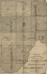
English: Covers Marietta region (Ga.) including portions of the present-day Cobb, Fulton, and Cherokee Counties. Original in Surveyor General Department, Office of Secretary of State, Atlanta, Ga. Available also through the Library of Congress Web site as a raster image. LC copy annotated in ink on verso: Cherokee County--gold dist.--sect. 2. |
||
| Title | A map of the second section of that part of Georgia now known as the Cherokee Territory in which are delineated all the districts & lots which by an act of the General Assembly were designated the Gold Districts and taken from actual survey | ||
| Shelf ID | G3921.B5 183- .G71 | ||
| Date | |||
| Source | https://www.loc.gov/item/82690523/ | ||
| Author | Green, Orange; Cowles, Daggett & Co. | ||
| Permission (Reusing this file) |
|
||
| Other versions |
|
||
| Location | Fulton County · Marietta Region · United States · Georgia · Cherokee County · Cobb County | ||
| Part of | American Memory · General Maps · Catalog · Geography And Map Division | ||
| Subject | Surveys · Georgia · Marietta Region · Cobb County (Ga.) · Cherokee County (Ga.) · United States · Maps · Fulton County · Fulton County (Ga.) · Cobb County · Marietta Region (Ga.) |


Licensing
[edit]|
This is a faithful photographic reproduction of a two-dimensional, public domain work of art. The work of art itself is in the public domain for the following reason:
The official position taken by the Wikimedia Foundation is that "faithful reproductions of two-dimensional public domain works of art are public domain".
This photographic reproduction is therefore also considered to be in the public domain in the United States. In other jurisdictions, re-use of this content may be restricted; see Reuse of PD-Art photographs for details. | ||||
File history
Click on a date/time to view the file as it appeared at that time.
| Date/Time | Thumbnail | Dimensions | User | Comment | |
|---|---|---|---|---|---|
| current | 15:27, 25 June 2018 |  | 7,655 × 12,112 (265.27 MB) | Fæ (talk | contribs) | LOC Maps https://www.loc.gov/item/82690523/ #28146 |
You cannot overwrite this file.
File usage on Commons
The following page uses this file: