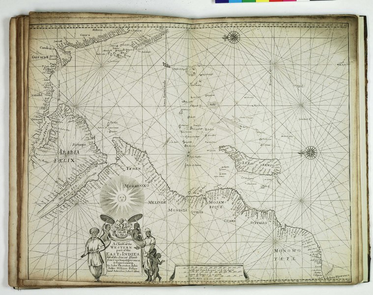
File:A chart of the western part of the East Indies. With all the adjacent islands, from Cape Bona Esperanca to Cape Comorin RMG F8088.tiff
Jump to navigation
Jump to search

Size of this JPG preview of this TIF file: 759 × 600 pixels. Other resolutions: 304 × 240 pixels | 607 × 480 pixels | 972 × 768 pixels | 1,280 × 1,012 pixels | 2,560 × 2,023 pixels | 4,800 × 3,794 pixels.
Original file (4,800 × 3,794 pixels, file size: 52.1 MB, MIME type: image/tiff)
Captions
Captions
Add a one-line explanation of what this file represents
Summary
[edit]| Author |
James Atkinson; John Colson; John Seller; John Thornton; William Fisher |
| Description |
English: A chart of the western part of the East Indies. With all the adjacent islands, from Cape Bona Esperanca to Cape ComorinBound sheet. Engr. Scale: [ca. 1:14 000 000 (bar)]. Cartographic Note: North at 270 degrees. Borders graduated for latitude. Plane chart. Bar scales in English and French leagues, Spanish leagues and Dutch miles (altered from first state of chart). Additional Places: Indian Ocean. A chart from the 'English Pilot, the Third Book, describing ... the Oriental Navigation'. Although it has the same title and coverage as a chart in Seller's 1675 Atlas Maritimus, this is a new plate. The graduation, coastlines and placenames all show differences. PBE6858, English Pilot Book 3, w part E Indies |
| Date | 1677 |
| Dimensions | Printed area 43 x 53 cm, on sheet 45 x 54.5 cm. |
| Source/Photographer | http://collections.rmg.co.uk/collections/objects/542875 |
| Permission (Reusing this file) |
The original artefact or artwork has been assessed as public domain by age, and faithful reproductions of the two dimensional work are also public domain. No permission is required for reuse for any purpose. The text of this image record has been derived from the Royal Museums Greenwich catalogue and image metadata. Individual data and facts such as date, author and title are not copyrightable, but reuse of longer descriptive text from the catalogue may not be considered fair use. Reuse of the text must be attributed to the "National Maritime Museum, Greenwich, London" and a Creative Commons CC-BY-NC-SA-3.0 license may apply if not rewritten. Refer to Royal Museums Greenwich copyright. |
| Identifier | id number: PBE6865(10) |
| Collection | Charts and maps |
Licensing
[edit]|
This is a faithful photographic reproduction of a two-dimensional, public domain work of art. The work of art itself is in the public domain for the following reason:
The official position taken by the Wikimedia Foundation is that "faithful reproductions of two-dimensional public domain works of art are public domain".
This photographic reproduction is therefore also considered to be in the public domain in the United States. In other jurisdictions, re-use of this content may be restricted; see Reuse of PD-Art photographs for details. | ||||
File history
Click on a date/time to view the file as it appeared at that time.
| Date/Time | Thumbnail | Dimensions | User | Comment | |
|---|---|---|---|---|---|
| current | 04:16, 20 August 2017 |  | 4,800 × 3,794 (52.1 MB) | Fæ (talk | contribs) | Royal Museums Greenwich Charts and maps, http://collections.rmg.co.uk/collections/objects/542875 |
You cannot overwrite this file.
File usage on Commons
The following page uses this file: