File:A Plan of the City and Harbour of Macao.jpg

From Wikimedia Commons, the free media repository
Jump to navigation Jump to search

Original file(1,124 × 1,536 pixels, file size: 1.3 MB, MIME type: image/jpeg)

Captions

Captions

Add a one-line explanation of what this file represents

Summary

[edit]
Description
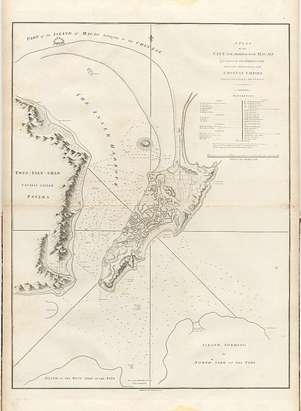
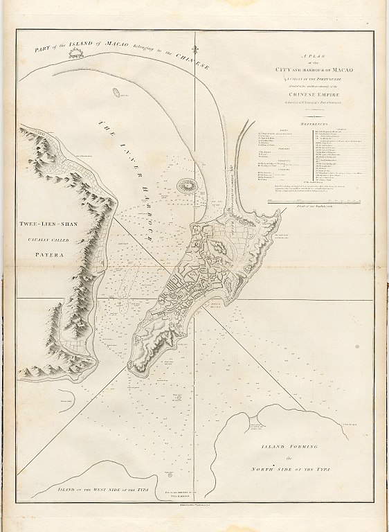
English: "A Plan of the City and Harbour of Macao: A Colony of the Portugueze, Situated at the Southern Extremity of the Chinese Empire in Lat. 22° 12′ 44″ N., long. 113° 35′ 0″ east of Greenwich. Engraved by B. Baker, Islington.


References
Forts
1 Santo Paulo del monte called also Monte Carmelo
2 Nossa Senhora de Guia
3 San Iago de la Barra
4 Nossa Senhora de Buen Parte
5 San Francisco
6 El Porta de San Pedro

Parishes
7 The Cathedral
8 San Lorenzo
9 San Antonio

Colleges
(both built by the Jesuits)
10 The Royal College of Saint Joseph
11 The College of Saint Paul

Convents
(Convents of Friars)
12 The Augustine
13 The Franciscan
14 The Dominican
(... of Nuns)
15 Santa Clara

Chapels
16 Of the Hospital La Misericordia
17 Of the Hospital San Lazaro
18 ... Nossa Senhora de la Pena de Francia
19 ... La Misericordia

Other Buildings & Places most remarkable
20 The Senate House
21 The Custom House
22 The Gate of Saint Lazarus
23 The Gate of Saint Antonio
24 The Gate of Saint Francisco
25 The Square of La Misericordia
26 Manduco's landing place
27 & 28 Small landing places
29 The Great landing place
30 The market place
31 Isla Verde
32 Puerta del Cerco
33 Tchin-shang a Chinese City called by the Portugueze Casa Blanca
34 Sang-miau a Chinese Temple
35 San a Chinese Town
36 A Chinese Temple
37 The English Factory

Note. The Soundings are marked down in feet and express those at the lowest ebb about the conjunction of the Sun and Moon when the tide rises generally about ten feet. The time of high water in the harbour at full and change is at 9h 52. 69 × 52 cm. Prepared for inclusion in the unnumbered folio volume of plates accompanying An Authentic Account of an Embassy from the King of Great Britain to the Emperor of China by George Staunton. In Staunton's book, glossed as: A plan of the city and harbour of Macao, a colony of the Portugueze, situated at the southern extremity of the Chinese empire; containing references to all the forts, colleges, convents, and other public buildings and places of note; and also the depth of water, and nature of the ground, in every part of the inner harbour, as well as in the space between the peninsula and the northern entrance into the Typa; taken from an accurate survey made by a gentleman long resident on the spot.
Date
Source Global Mapping of Macao
Author Benjamin Baker
Other versions

Licensing

[edit]
Public domain

This work is in the public domain in its country of origin and other countries and areas where the copyright term is the author's life plus 70 years or fewer.


This work is in the public domain in the United States because it was published (or registered with the U.S. Copyright Office) before January 1, 1929.

Annotations
InfoField
This image is annotated: View the annotations at Commons

File history

Click on a date/time to view the file as it appeared at that time.

Date/TimeThumbnailDimensionsUserComment
current23:39, 30 December 2017Thumbnail for version as of 23:39, 30 December 20171,124 × 1,536 (1.3 MB)LlywelynII (talk | contribs)User created page with UploadWizard

The following page uses this file:

File usage on other wikis

The following other wikis use this file: