File:A Map of the British and French settlements in North America - (part the second) containing part of New York, Pensilvania, New Jersey, Mary Land, Virginia, North and South Carolina, Georgia, NYPL434855.tiff
Jump to navigation
Jump to search

Size of this JPG preview of this TIF file: 800 × 421 pixels. Other resolutions: 320 × 169 pixels | 640 × 337 pixels | 1,024 × 539 pixels | 1,280 × 674 pixels | 2,560 × 1,348 pixels | 6,227 × 3,280 pixels.
Original file (6,227 × 3,280 pixels, file size: 38.99 MB, MIME type: image/tiff)
Captions
Captions
Add a one-line explanation of what this file represents
Summary
[edit]| Description | A Map of the British and French settlements in North America : (part the second) containing part of New York, Pensilvania, New Jersey, Mary Land, Virginia, North and South Carolina, Georgia, Louisiana, and all the countries westward in the same parellels so far as discovered, shewing the course of the Rivers Ohio, Missisipi etc exhibiting the just boundaries and the French encroachments laid down from authentic surveys / T. Bowen, sc.; Maps of North America. / Countries / United States (except New York) / Parts | |||||||||||||||||||||||
| Notes | From General magazine of arts and sciences. Miscellaneous correspondence, v. 1, May 1755. ''Note 2.'') From General magazine of arts and sciences. Miscellaneous correspondence, v. 1, May 1755. ''Note 3.'') From General magazine of arts and sciences. Miscellaneous correspondence, v. 1, May 1755. ''Note 4.'') From General magazine of arts and sciences. Miscellaneous correspondence, v. 1, May 1755. ''Note 5.'') From General magazine of arts and sciences. Miscellaneous correspondence, v. 1, May 1755. ''Note 6.'') Includes notes on the Indian tribes and historical events. ''Note 7.'') National Endowment for the Humanities Grant for Access to Early Maps of the Middle Atlantic Seaboard. ''Note 8.'') Prime meridian: London. ''Note 9.'') Relief shown pictorially. | |||||||||||||||||||||||
| Catalogue call number | Map Div. 01-5179 | |||||||||||||||||||||||
| Standard reference | Jolly, D.C. Maps of America in periodicals before 1800, 51 | |||||||||||||||||||||||
| Date | ||||||||||||||||||||||||
| Source |
http://digitalgallery.nypl.org/nypldigital/dgkeysearchdetail.cfm?imageID=434855
|
|||||||||||||||||||||||
| Author | Bowen, Thomas, d. 1790 -- Engraver ;Owen, W. (William), d. 1793 -- Publisher | |||||||||||||||||||||||
| Permission (Reusing this file) |
From The Lionel Pincus and Princess Firyal Map Division. http://maps.nypl.org
|
|||||||||||||||||||||||
| Location | Stephen A. Schwarzman Building / The Lionel Pincus and Princess Firyal Map Division | |||||||||||||||||||||||
| Digital item published | 2-3-2004; updated 3-25-2011 | |||||||||||||||||||||||
| Digital ID | 434855 | |||||||||||||||||||||||

The making of this file was supported by Wikimedia UK.
To see other files made with the support of Wikimedia UK, please see the category Supported by Wikimedia UK.
|
File history
Click on a date/time to view the file as it appeared at that time.
| Date/Time | Thumbnail | Dimensions | User | Comment | |
|---|---|---|---|---|---|
| current | 07:53, 3 August 2015 |  | 6,227 × 3,280 (38.99 MB) | Finavon (talk | contribs) | correct direction |
| 07:50, 3 August 2015 | 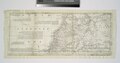 | 6,227 × 3,280 (39.06 MB) | Finavon (talk | contribs) | rotated | |
| 10:32, 20 April 2014 | 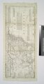 | 3,280 × 6,227 (58.44 MB) | Fæ (talk | contribs) | GWToolset:: Creating mediafile for Fæ. Tranche 2.590 |
You cannot overwrite this file.
File usage on Commons
There are no pages that use this file.