File:AMH-6924-KB Map of the world and chart of New Guinea.jpg
Jump to navigation
Jump to search

Size of this preview: 800 × 571 pixels. Other resolutions: 320 × 228 pixels | 640 × 457 pixels | 1,024 × 730 pixels | 1,280 × 913 pixels | 2,400 × 1,712 pixels.
Original file (2,400 × 1,712 pixels, file size: 961 KB, MIME type: image/jpeg)
Captions
Captions
Add a one-line explanation of what this file represents
Summary
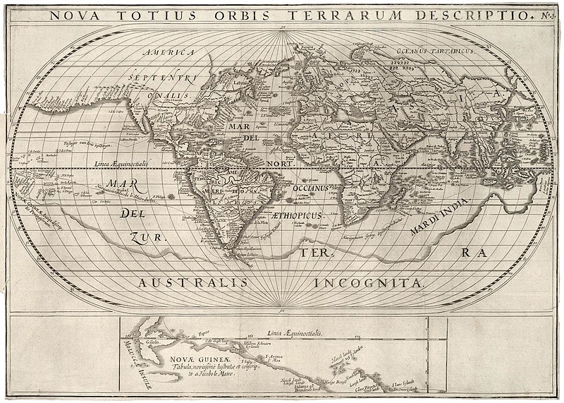
[edit]Nederlands: Wereldkaart en een kaart van Nieuw Guinea
English: Map of the world and chart of New Guinea( |
|||||||||||||||||||||
|---|---|---|---|---|---|---|---|---|---|---|---|---|---|---|---|---|---|---|---|---|---|
| Author |
Nederlands: Anoniem / Anonymous (landmeter / kaartenmaker), Jan Jansz (uitgever)
English: Anoniem / Anonymous (land surveyor / mapmaker), Jan Jansz (publisher) |
||||||||||||||||||||
| Title |
Nederlands: Wereldkaart en een kaart van Nieuw Guinea
English: Map of the world and chart of New Guinea |
||||||||||||||||||||
| Description |
Nederlands: Wereldkaart en een kaart van Nieuw Guinea.
De kaart van Nieuw Guinea werd vervaardigd tijdens de reis van Schouten en Le Maire in 1616.
English: Map of the world and a chart of New Guinea.
The map of New Guinea was drawn during the voyage of Schouten and Le Maire in 1616. |
||||||||||||||||||||
| Date | circa 1621 | ||||||||||||||||||||
| Medium |
Nederlands: gravure op papier
English: engraving on paper |
||||||||||||||||||||
| Dimensions | height: 45.5 cm (17.9 in); width: 32.5 cm (12.7 in) | ||||||||||||||||||||
| Collection |
|
||||||||||||||||||||
| Accession number |
551 J 49 voor p. 9 |
||||||||||||||||||||
| Inscriptions |
Nova Totius Orbis Terrarum Descriptio
|
||||||||||||||||||||
| Notes |
English: Subjects: chart / map / plan
Nederlands: Onderwerpen: plattegrond / kaart
English: Post: this image is related to a VOC trading post called Salvador |
||||||||||||||||||||
| Source/Photographer |
|
||||||||||||||||||||
| Permission (Reusing this file) |
|
||||||||||||||||||||

| Object location | | View this and other nearby images on: OpenStreetMap |
|---|
File history
Click on a date/time to view the file as it appeared at that time.
| Date/Time | Thumbnail | Dimensions | User | Comment | |
|---|---|---|---|---|---|
| current | 11:51, 10 June 2014 | | 2,400 × 1,712 (961 KB) | HuskyBot (talk | contribs) | == {{int:filedesc}} == {{Artwork |title = {{nl|1=Wereldkaart en een kaart van Nieuw Guinea}} {{en|1=Map of the world and chart of New Guinea}} |description = {{nl|1=Wereldkaart en een kaart van Nieuw Guinea. D... |
You cannot overwrite this file.
File usage on Commons
The following page uses this file:
File usage on other wikis
The following other wikis use this file:
- Usage on fr.wikipedia.org