File:AMH-6328-KB Map of a stretch of the West African coast.jpg
Original file (2,400 × 1,961 pixels, file size: 761 KB, MIME type: image/jpeg)
Captions
Captions
Summary
[edit]Nederlands: Kaart van een gedeelte van de West-Afrikaanse kust
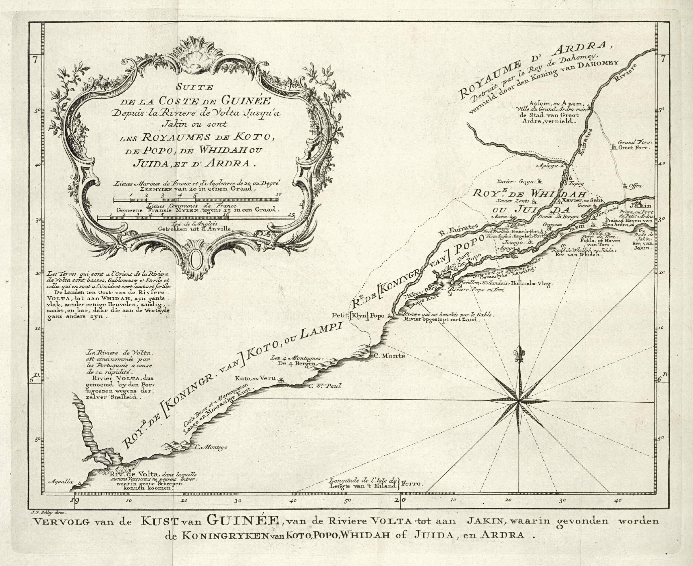
English: Map of a stretch of the West African coast( |
|||||||||||||||||||||||||||||||||||||||||||||
|---|---|---|---|---|---|---|---|---|---|---|---|---|---|---|---|---|---|---|---|---|---|---|---|---|---|---|---|---|---|---|---|---|---|---|---|---|---|---|---|---|---|---|---|---|---|
| Author |
Nederlands: Jacobus van der Schley (direxit), Pierre d' Hondt (uitgever)
English: Jacobus van der Schley (direxit), Pierre d' Hondt (publisher) |
||||||||||||||||||||||||||||||||||||||||||||
| Title |
Nederlands: Kaart van een gedeelte van de West-Afrikaanse kust
English: Map of a stretch of the West African coast |
||||||||||||||||||||||||||||||||||||||||||||
| Description |
Nederlands: Kaart van een gedeelte van de West-Afrikaanse kust.
Vervolg van de Kust van Guinée, van de Riviere Volta tot aan Jakin, waarin gevonden worden de Koningryken van Koto, Popo, Whidah of Juida, en Ardra. Suite de la Coste de Guinée Depuis la Riviere de Volta Jusqu'a Jakin ou sont les Royaumes de Koto, de Popo, de Whidah ou Juida, et d'Ardra.English: Map of a stretch of the West African coast.
Vervolg van de Kust van Guinée, van de Riviere Volta tot aan Jakin, waarin gevonden worden de Koningryken van Koto, Popo, Whidah of Juida, en Ardra. Suite de la Coste de Guinée Depuis la Riviere de Volta Jusqu'a Jakin ou sont les Royaumes de Koto, de Popo, de Whidah ou Juida, et d'Ardra. |
||||||||||||||||||||||||||||||||||||||||||||
| Date | 1747 | ||||||||||||||||||||||||||||||||||||||||||||
| Medium |
Nederlands: gravure op papier
English: engraving on paper |
||||||||||||||||||||||||||||||||||||||||||||
| Dimensions | height: 20 cm (7.8 in); width: 16.5 cm (6.4 in) | ||||||||||||||||||||||||||||||||||||||||||||
| Collection |
|
||||||||||||||||||||||||||||||||||||||||||||
| Accession number |
693 C 6 dl. V na p. 355 |
||||||||||||||||||||||||||||||||||||||||||||
| Inscriptions |
Vervolg van de Kust van Guinée, van de Riviere Volta tot aan Jakin
author: J. v. Schley direx. |
||||||||||||||||||||||||||||||||||||||||||||
| Notes |
English: Subjects: chart / map / plan, compass / dial, banderole / cartouche / ornamentation
Nederlands: Onderwerpen: plattegrond / kaart, kompas / windroos, banderol / cartouche / versiering
English: Post: this image is related to a WIC trading post called Aneho |
||||||||||||||||||||||||||||||||||||||||||||
| Source/Photographer |
|
||||||||||||||||||||||||||||||||||||||||||||
| Permission (Reusing this file) |
|
||||||||||||||||||||||||||||||||||||||||||||

| Object location | | View this and other nearby images on: OpenStreetMap |
|---|
File history
Click on a date/time to view the file as it appeared at that time.
| Date/Time | Thumbnail | Dimensions | User | Comment | |
|---|---|---|---|---|---|
| current | 11:02, 10 June 2014 | | 2,400 × 1,961 (761 KB) | HuskyBot (talk | contribs) | == {{int:filedesc}} == {{Artwork |title = {{nl|1=Kaart van een gedeelte van de West-Afrikaanse kust}} {{en|1=Map of a stretch of the West African coast}} |description = {{nl|1=Kaart van een gedeelte van de West... |
You cannot overwrite this file.
File usage on Commons
The following page uses this file:
File usage on other wikis
The following other wikis use this file:
- Usage on fi.wikipedia.org
- Usage on fi.wikibooks.org