File:AMH-6178-NA Map of Taiwan.jpg
Jump to navigation
Jump to search
Size of this preview: 800 × 324 pixels. Other resolutions: 320 × 129 pixels | 640 × 259 pixels | 1,024 × 414 pixels | 2,400 × 971 pixels.
Original file (2,400 × 971 pixels, file size: 304 KB, MIME type: image/jpeg)
Captions
Captions
Add a one-line explanation of what this file represents
Summary
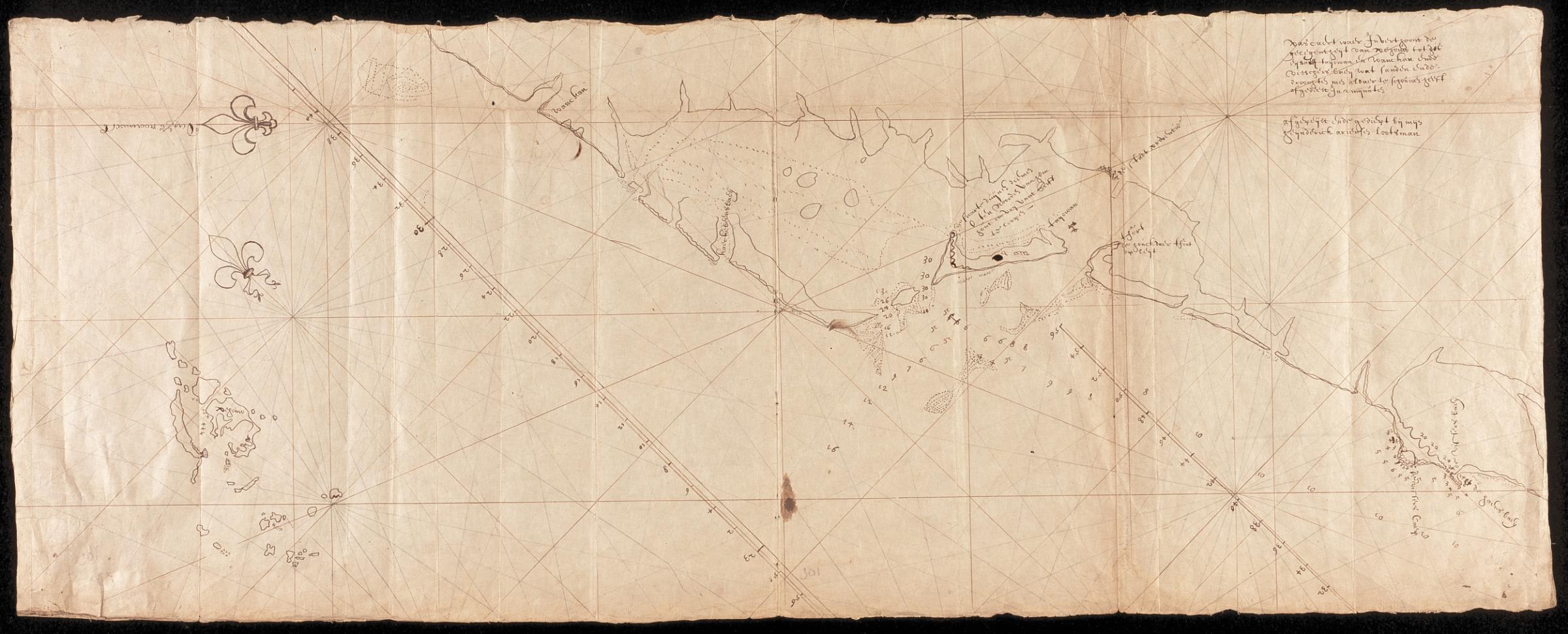
[edit]Nederlands: Kaart van Taiwan
English: Map of Taiwan( |
||||||||||||||||||||||||
|---|---|---|---|---|---|---|---|---|---|---|---|---|---|---|---|---|---|---|---|---|---|---|---|---|
| Author |
Creator:Heyndrick Ariensen Lootsman Nederlands: Heyndrick Ariensen Lootsman (landmeter / kaartenmaker)
English: Heyndrick Ariensen Lootsman (land surveyor / mapmaker) |
|||||||||||||||||||||||
| Title |
Nederlands: Kaart van Taiwan
English: Map of Taiwan |
|||||||||||||||||||||||
| Description |
Nederlands: Titel catalogus Leupe (NA): Pascaert, waarin verthoont de gelegentheyt van Pehouw tot het Eylandt Tayowan en Wankan, ende Visschersbaey enz..
Op Japans papier; aan de randen zijn stroken Japans papier geplakt. Notities verso: Caerte van Teijouan ende Pehouw.English: Title in the Leupe catalogue (NA):Pascaert, waarin verthoont de gelegentheyt van Pehouw tot het Eylandt Tayowan en Wankan, ende Visschersbaey enz..
On Japanese paper; strips of Japanese paper have been pasted along the edges. Notes on reverse:Caerte van Teijouan ende Pehouw. |
|||||||||||||||||||||||
| Date | between 1624 and 1625 | |||||||||||||||||||||||
| Medium |
Nederlands: pen op papier
English: pen on paper |
|||||||||||||||||||||||
| Dimensions | height: 98 cm (38.5 in); width: 38 cm (14.9 in) | |||||||||||||||||||||||
| Collection |
|
|||||||||||||||||||||||
| Accession number |
NL-HaNA_4.VEL_301 (old number: VEL0301) |
|||||||||||||||||||||||
| Notes |
English: Subjects: fortification, chart / map / plan, banderole / cartouche / ornamentation, building
Nederlands: Onderwerpen: vesting, plattegrond / kaart, banderol / cartouche / versiering, gebouw |
|||||||||||||||||||||||
| Source/Photographer |
|
|||||||||||||||||||||||
| Permission (Reusing this file) |
|
|||||||||||||||||||||||

| Object location | | View this and other nearby images on: OpenStreetMap |
|---|
File history
Click on a date/time to view the file as it appeared at that time.
| Date/Time | Thumbnail | Dimensions | User | Comment | |
|---|---|---|---|---|---|
| current | 09:13, 11 June 2014 | 2,400 × 971 (304 KB) | HuskyBot (talk | contribs) | == {{int:filedesc}} == {{Artwork |title = {{nl|1=Kaart van Taiwan}} {{en|1=Map of Taiwan}} |description = {{nl|1=Titel catalogus Leupe (NA): ''Pascaert, waarin verthoont de gelegentheyt van Pehouw tot het Eylan... |
You cannot overwrite this file.
File usage on Commons
The following page uses this file: