Category:Old maps of Penghu
Jump to navigation
Jump to search
中文(臺灣):澎湖縣的古地圖
Media in category "Old maps of Penghu"
The following 47 files are in this category, out of 47 total.
-
 AMH-4839-NA Map of the Taouan peninsula.jpg 2,400 × 1,118; 381 KB
-
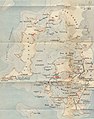
 AMH-5187-NA Map of the Pescadores and the west coast of Formosa.jpg 2,400 × 1,875; 558 KB
-
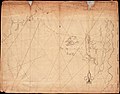
 AMH-6178-NA Map of Taiwan.jpg 2,400 × 971; 304 KB
-
 Piscadores 1664.jpg 1,597 × 1,534; 636 KB
-
 Taiwan di li tu.jpg 1,636 × 995; 565 KB
-
 臺灣地里圖1.jpg 19,683 × 7,900; 67.83 MB
-
 1727 Map of Formosa-Taiwan by the Dutch 荷蘭文福爾摩沙-臺灣地圖.jpg 1,663 × 1,377; 1.61 MB
-
 L'Ile de Formosa 1.jpg 800 × 604; 113 KB
-
 L'Ile de Formosa.jpg 652 × 541; 138 KB
-
 KAART Eyland Formosa.gif 621 × 788; 366 KB
-
 Kaart Van Het Eyland Formosa (small, color).jpg 874 × 704; 207 KB
-
 Kaart van het Eyland Formosa en de Eylanden van Piscadores.jpg 4,522 × 3,644; 11.35 MB
-
 Kaart van het Eyland Formosa.jpg 2,400 × 1,931; 683 KB
-
 Old Taiwan map.jpg 1,744 × 1,236; 1,021 KB
-

-
 Dutch-pescadores.png 989 × 656; 684 KB
-

-
 Map of Taiwan and the Pescadores Islands WDL208.png 1,701 × 1,024; 3.35 MB
-
 臺灣前後山全圖.jpg 13,206 × 16,381; 54.42 MB
-
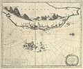
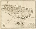
 1901 Map of the Pescadores Islands.jpg 581 × 607; 114 KB
-
 Admiralty Chart No 1028 Pehoe, or Ponghou Islands, Published 1792.jpg 8,478 × 5,356; 8.51 MB
-

-

-
 China 1689-1722 Frontier - Taiwan.jpg 11,569 × 6,664; 14.45 MB
-
 City wall of Penghu in 1894.jpg 3,045 × 2,482; 2.22 MB
-
-
 Fokyen.jpg 1,127 × 1,032; 205 KB
-
 Garnot Pescadores.jpg 921 × 1,169; 397 KB
-
 Les Pescadores (Mouillages intérieurs & Ile Ponghou.) (Croquis No. 10).tif 5,000 × 8,278; 157.9 MB
-
 Location map of schools in Takao and Hoko 1927.jpg 783 × 1,200; 184 KB
-
 Mako 1 8000 1945.jpg 4,350 × 4,752; 4.68 MB
-
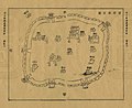
 Map of Dutch Fortress on Penghu, c. 1623.jpg 1,000 × 856; 349 KB
-
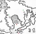
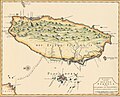
 Map of Penghu in early Qing Dynasty.jpg 906 × 1,024; 387 KB
-

-
 媽宮街井位置圖.jpg 2,958 × 2,419; 3.7 MB
-
 清代澎湖廳西嶼澳聚落分布圖:二崁.jpg 5,100 × 6,938; 2.62 MB
-
 清代澎湖廳西嶼澳聚落分布圖:內塹(內垵).jpg 6,731 × 5,100; 5.02 MB
-
 清代澎湖廳西嶼澳聚落分布圖:合界、后螺.jpg 4,956 × 6,938; 2.73 MB
-
 清代澎湖廳西嶼澳聚落分布圖:外塹(外垵).jpg 6,919 × 4,888; 4.72 MB
-
 清代澎湖廳西嶼澳聚落分布圖:大池角.jpg 6,875 × 4,925; 5.47 MB
-
 清代澎湖廳西嶼澳聚落分布圖:小池角.jpg 5,100 × 7,006; 3.48 MB
-
 清代澎湖廳西嶼澳聚落分布圖:小門.jpg 6,863 × 4,806; 2.22 MB
-
 清代澎湖廳西嶼澳聚落分布圖:橫礁.jpg 4,619 × 6,281; 3.45 MB
-
 清代澎湖廳西嶼澳聚落分布圖:竹篙灣(竹灣).jpg 4,975 × 6,875; 3.07 MB
-
 清代澎湖廳西嶼澳聚落分布圖:緝馬灣(赤馬).jpg 4,975 × 6,900; 2.96 MB
-
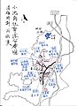
 清代澎湖輿圖 1885 (Old Map of Penghu).jpg 5,937 × 4,547; 3.81 MB
-
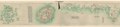
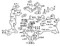
 澎湖輿圖 (1752).jpg 1,176 × 957; 429 KB


.jpg)


.jpg)
.jpg)