File:AMH-5472-NA Map of Semarang and environs.jpg
Jump to navigation
Jump to search
Size of this preview: 417 × 599 pixels. Other resolutions: 167 × 240 pixels | 334 × 480 pixels | 534 × 768 pixels | 712 × 1,024 pixels | 1,670 × 2,400 pixels.
Original file (1,670 × 2,400 pixels, file size: 586 KB, MIME type: image/jpeg)
Captions
Captions
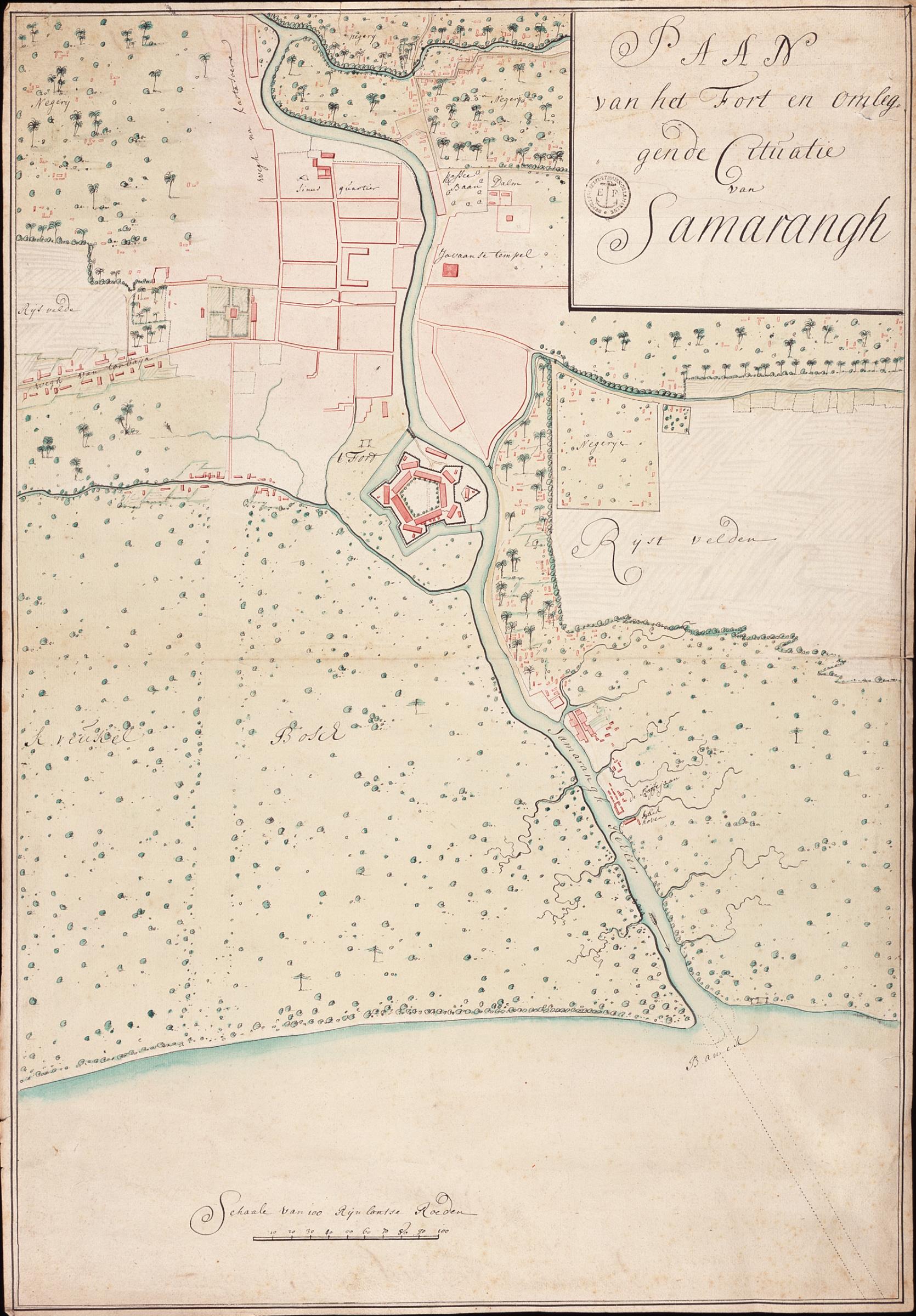
Map of Semarang and environs
Summary
[edit]Nederlands: Kaart van Semarang en omgeving
                     English:  Map of Semarang and environs
                     Bahasa Indonesia:  Peta Semarang dan sekitarnya
( |
||||||||||||||||||||||||
|---|---|---|---|---|---|---|---|---|---|---|---|---|---|---|---|---|---|---|---|---|---|---|---|---|
| Author |
Nederlands: Anoniem / Anonymous (landmeter / kaartenmaker)
English: Anoniem / Anonymous (land surveyor / mapmaker) |
|||||||||||||||||||||||
| Title |
Nederlands: Kaart van Semarang en omgeving
English: Map of Semarang and environs
Bahasa Indonesia: Peta Semarang dan sekitarnya |
|||||||||||||||||||||||
| Description |
Nederlands: Titel catalogus Leupe (NA): Plaan van het Fort en omleggende cituatie van Samarangh.
Notities verso: Plaan van het fort en omleggende cituatie van Samarang anno 1719 [twee keer] / No. 13 Samarang en Environs. Register 2, Deel 1, Folio 6, Portefeuille .. [geschreven op een blauw etiket] / 628 [met vette cijfers gestempeld op een etiketje] / No. 83. [vrij groot, op een etiket] / No. 188.
English: Title in the Leupe catalogue (NA): Plaan van het Fort en omleggende cituatie van Samarangh.
Notes on reverse: Plaan van het fort en omleggende cituatie van Samarang anno 1719 [twice] / No. 13 Samarang en Environs. Register 2, Deel 1, Folio 6, Portefeuille .. [inscribed on a blue label] / 628 [printed in bold on a small label] / No. 83. [relatively large, on a label] / No. 188.
Bahasa Indonesia: Judul dalam katalog Leupe (AN): Plaan van het Fort en omleggende cituatie van Samarangh.
Catatan di belakang: Plaan van het fort en omleggende cituatie van Samarang anno 1719 [dua kali] / No. 13 Samarang en Environs. Register 2, Deel 1, Folio 6, Portefeuille .. [dicetak di atas label biru] / 628 [dicetak tebal dalam sebuah label kecil] / No. 83. [berukuran besar, dalam sebuah label] / No. 188. |
|||||||||||||||||||||||
| Date | circa 1719 | |||||||||||||||||||||||
| Medium |
Nederlands: ingekleurde tekening op papier
English: coloured drawing on paper
Bahasa Indonesia: gambar berwarna di atas kertas |
|||||||||||||||||||||||
| Dimensions | height: 45.5 cm (17.9 in); width: 65.5 cm (25.7 in) | |||||||||||||||||||||||
| Collection |
|
|||||||||||||||||||||||
| Accession number |
NL-HaNA_4.VEL_1259 (old number: VEL1259) |
|||||||||||||||||||||||
| Inscriptions |
Paan van het Fort en omleggende cituatie van Samarangh
|
|||||||||||||||||||||||
| Notes |
English: Subjects: estate / plantation, fortification, banderole / cartouche / ornamentation, pagoda / temple, chart / map / plan
Nederlands: Onderwerpen: landerij / plantage, vesting, banderol / cartouche / versiering, pagode / tempel, plattegrond / kaart
English: Post: this image is related to a VOC trading post called Semarang |
|||||||||||||||||||||||
| Source/Photographer |
|
|||||||||||||||||||||||
| Permission (Reusing this file) |
|
|||||||||||||||||||||||

| Object location | | View this and other nearby images on: OpenStreetMap |
|---|
File history
Click on a date/time to view the file as it appeared at that time.
| Date/Time | Thumbnail | Dimensions | User | Comment | |
|---|---|---|---|---|---|
| current | 18:27, 10 June 2014 | | 1,670 × 2,400 (586 KB) | HuskyBot (talk | contribs) | == {{int:filedesc}} == {{Artwork |title = {{nl|1=Kaart van Semarang en omgeving}} {{en|1=Map of Semarang and environs}} |description = {{nl|1=Titel catalogus Leupe (NA): ''Plaan van het Fort en omleggende citua... |
You cannot overwrite this file.
File usage on Commons
The following page uses this file: