File:AMH-2479-NA Blueprint for the fortification of the Fort of Good Hope.jpg

Original file (1,811 × 2,400 pixels, file size: 668 KB, MIME type: image/jpeg)
Captions
Captions
Summary
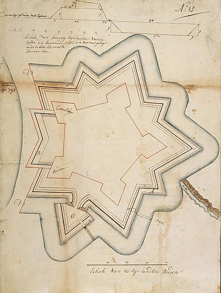
[edit]Nederlands: Plan voor de versterking van fort de Goede Hoop
English: Blueprint for the fortification of the Fort of Good Hope( |
||||||||||||||||||||||||
|---|---|---|---|---|---|---|---|---|---|---|---|---|---|---|---|---|---|---|---|---|---|---|---|---|
| Author |
Creator:Evert Walraven Cochius / Cochenius Nederlands: Evert Walraven Cochius / Cochenius (toegeschreven aan landmeter/kaartenmaker)
English: Evert Walraven Cochius / Cochenius (assigned to land surveyor / mapmaker) |
|||||||||||||||||||||||
| Title |
Nederlands: Plan voor de versterking van fort de Goede Hoop
English: Blueprint for the fortification of the Fort of Good Hope |
|||||||||||||||||||||||
| Description |
Nederlands: Titel catalogus Leupe (NA): Plan ter versterking van fortres de Goede Hoop.
Rechtsboven: N:o 15. In de marge: 2e Caap 1720 overgekomen fol. 791. Gerestaureerd op linnen. Door Leupe toegeschreven aan Cochius of Cochenius. Term genoemd op de kaart: ravelijn. Punten genoemd op de kaart: punt Buuren, Cattenelleboge.English: The original title according to the catalogue Leupe (NA) reads: Plan ter versterking van fortres de Goede Hoop.
Upper right: N:o 15. In the margins: 2e Caap 1720 overgekomen fol. 791. Restored on linen. According to Leupe assigned to Cochius or Cochenius. Term mentioned: ravelijn. Places mentioned on this map are: punt Buuren, Cattenelleboge. |
|||||||||||||||||||||||
| Date | circa 1720 | |||||||||||||||||||||||
| Medium |
Nederlands: ingekleurde tekening op papier / linnen
English: coloured drawing on paper / linen |
|||||||||||||||||||||||
| Dimensions | height: 75 cm (29.5 in); width: 47 cm (18.5 in) | |||||||||||||||||||||||
| Collection |
|
|||||||||||||||||||||||
| Accession number |
NL-HaNA_4.VEL_832 (old number: VEL0832) |
|||||||||||||||||||||||
| Inscriptions |
Schale van seventig Rijnlandtse voeten hebben dese bovenstaande profil in de voetmaat gebrogt om des te beter het werk te kunnen zien
|
|||||||||||||||||||||||
| Notes |
English: Subjects: chart / map / plan, fortification, cross-section / profile
Nederlands: Onderwerpen: plattegrond / kaart, vesting, doorsnede / profiel
English: Fort: this image is related to a VOC fort called kasteel de Goede Hoop |
|||||||||||||||||||||||
| Source/Photographer |
|
|||||||||||||||||||||||
| Permission (Reusing this file) |
|
|||||||||||||||||||||||

| Object location | | View this and other nearby images on: OpenStreetMap |
|---|
File history
Click on a date/time to view the file as it appeared at that time.
| Date/Time | Thumbnail | Dimensions | User | Comment | |
|---|---|---|---|---|---|
| current | 15:42, 10 June 2014 | | 1,811 × 2,400 (668 KB) | HuskyBot (talk | contribs) | == {{int:filedesc}} == {{Artwork |title = {{nl|1=Plan voor de versterking van fort de Goede Hoop}} {{en|1=Blueprint for the fortification of the Fort of Good Hope}} |description = {{nl|1=Titel catalogus Leupe (... |
You cannot overwrite this file.
File usage on Commons
The following page uses this file: