File:AMH-2477-NA Ground plan of the Fort of Good Hope.jpg

Original file (2,400 × 1,822 pixels, file size: 629 KB, MIME type: image/jpeg)
Captions
Captions
Summary
[edit]Nederlands: Plattegrond van het fort de Goede Hoop
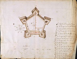
English: Ground plan of the Fort of Good Hope( |
||||||||||||||||||||||||
|---|---|---|---|---|---|---|---|---|---|---|---|---|---|---|---|---|---|---|---|---|---|---|---|---|
| Author |
Nederlands: Anoniem / Anonymous
English: Anoniem / Anonymous |
|||||||||||||||||||||||
| Title |
Nederlands: Plattegrond van het fort de Goede Hoop
English: Ground plan of the Fort of Good Hope |
|||||||||||||||||||||||
| Description |
Nederlands: Titel catalogus Leupe (NA): Plan van het Fortres de Goede Hoop.
Notities verso: Fort de Goede Hoop uit Brieven en Papieren van de Kaap overgekomen in 1691 nr. 45; 498 u. Legenda: A-S Genoemde termen op de kaart: vijfhoek, ravelijn, borstwering.English: The original title according to the catalogue Leupe (NA) reads: Plan van het Fortres de Goede Hoop.
Notes on reverse: Fort de Goede Hoop uit Brieven en Papieren van de Kaap overgekomen in 1691 nr. 45; 498 u. Key: A-S Terms mentioned on this map are: vijfhoek, ravelijn, borstwering. |
|||||||||||||||||||||||
| Date | circa 1691 | |||||||||||||||||||||||
| Medium |
Nederlands: ingekleurde tekening op papier
English: coloured drawing on paper |
|||||||||||||||||||||||
| Dimensions | height: 44 cm (17.3 in); width: 34 cm (13.3 in) | |||||||||||||||||||||||
| Collection |
|
|||||||||||||||||||||||
| Accession number |
NL-HaNA_4.VEL_829 (old number: VEL0829) |
|||||||||||||||||||||||
| Inscriptions |
't Fortres de goede hoop
|
|||||||||||||||||||||||
| Notes |
English: Subjects: chart / map / plan, survey / view, fortification, key, compass / dial
Nederlands: Onderwerpen: plattegrond / kaart, overzicht / aanzicht, vesting, legenda, kompas / windroos
English: Fort: this image is related to a VOC fort called kasteel de Goede Hoop |
|||||||||||||||||||||||
| Source/Photographer |
|
|||||||||||||||||||||||
| Permission (Reusing this file) |
|
|||||||||||||||||||||||

| Object location | | View this and other nearby images on: OpenStreetMap |
|---|
File history
Click on a date/time to view the file as it appeared at that time.
| Date/Time | Thumbnail | Dimensions | User | Comment | |
|---|---|---|---|---|---|
| current | 11:16, 20 May 2014 | | 2,400 × 1,822 (629 KB) | HuskyBot (talk | contribs) | == {{int:filedesc}} == {{Artwork |title = {{nl|Plattegrond van het fort de Goede Hoop}} {{en|Ground plan of the Fort of Good Hope}} |description = {{nl|Titel catalogus Leupe (NA): <Plan van het Fortres de Go... |
You cannot overwrite this file.
File usage on Commons
The following page uses this file: