File:ALASKAN WAY SOUTH, LOOKING NORTH NORTHEAST. SOUTHEAST AND WEST FACES OF VIADUCT VISIBLE. - Alaskan Way Viaduct and Battery Street Tunnel, Seattle, King County, WA HAER WA-184-3.tif

Original file (5,148 × 3,704 pixels, file size: 18.19 MB, MIME type: image/tiff)
Captions
Captions
Summary
[edit]| ALASKAN WAY SOUTH, LOOKING NORTH NORTHEAST. SOUTHEAST AND WEST FACES OF VIADUCT VISIBLE. - Alaskan Way Viaduct and Battery Street Tunnel, Seattle, King County, WA | ||||
|---|---|---|---|---|
| Photographer |
Lowe, Jet |
|||
| Title |
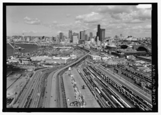
ALASKAN WAY SOUTH, LOOKING NORTH NORTHEAST. SOUTHEAST AND WEST FACES OF VIADUCT VISIBLE. - Alaskan Way Viaduct and Battery Street Tunnel, Seattle, King County, WA |
|||
| Description |
City of Seattle Engineering Department; Washington Department of Highways Bridge Division; Washington State Department of Transportation; Bollong, J W A; Murray, Ray; Morrison-Knudsen Company, Inc.; McRae Brothers; Stevens, George; Rumsey and Company; Finke, R W; Northwest Engineering Electric Company; Pacific Car and Foundry; Willar Construction Company; Willar Construction Company; Washington State Department of Transportation, sponsor; Christianson, Justine, transmitter |
|||
| Depicted place | Washington; King County; Seattle | |||
| Date | 2008 | |||
| Dimensions | 5 x 7 in. | |||
| Current location |
Library of Congress Prints and Photographs Division Washington, D.C. 20540 USA http://hdl.loc.gov/loc.pnp/pp.print |
|||
| Accession number |
HAER WA-184-3 |
|||
| Credit line |
|
|||
| Notes |
The Battery Street Tunnel was the City of Seattle Engineering Department's first venture into tunnel design. It was designed and built to minimize traffic disruption and reduce risk to neighboring buildings. Its health and safety features were innovative at the time, including a ventilation system actuated by carbon monoxide monitors and a heat-actuated automatic sprinkler system. The viaduct and the tunnel played an important role in the development of Seattle and the region by providing a direct connection through downtown Seattle and to the industrial areas to the south.
|
|||
| Source | https://www.loc.gov/pictures/item/wa0830.photos.366397p | |||
| Permission (Reusing this file) |
|
|||

| Annotations | This image is annotated: View the annotations at Commons |
File history
Click on a date/time to view the file as it appeared at that time.
| Date/Time | Thumbnail | Dimensions | User | Comment | |
|---|---|---|---|---|---|
| current | 00:02, 5 August 2014 |  | 5,148 × 3,704 (18.19 MB) | Fæ (talk | contribs) | GWToolset: Creating mediafile for Fæ. HABS 2014-08-04 (3601:3800) Penultimate Tranche! |
You cannot overwrite this file.
File usage on Commons
The following page uses this file:
Metadata
- Alaskan Way, Seattle
- Aerial views of the Alaskan Way Viaduct
- T-Mobile Park
- Lumen Field
- Downtown, Seattle, Washington
- Queen Anne, Seattle, Washington
- First Hill, Seattle, Washington
- Elliott Bay
- Seattle Terminal 46
- Seattle International Gateway (SIG) Intermodal Facility
- Industrial District, Seattle, Washington
- Container terminals in the United States