
File:4thCrossing.png

Size of this preview: 800 × 519 pixels. Other resolutions: 320 × 208 pixels | 640 × 415 pixels | 1,024 × 664 pixels | 1,489 × 966 pixels.
Original file (1,489 × 966 pixels, file size: 2.66 MB, MIME type: image/png)
Captions
Captions
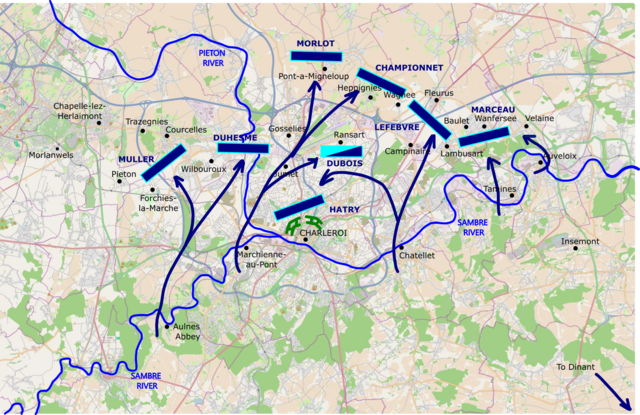
Map showing the positions taken up by the French divisions on the Sambre after they crossed for the 4th time
Summary
[edit]
| Description |
English: Showing the positions taken by French forces after the 4th crossing of the Sambre, just prior to the second siege of Charleroi, superimposed on a modern map with historical locations.
Background map © OpenStreetMap contributors Superimposed annotations and mapping © Talamioros |
| Date | |
| Source | Own work based on: https://mc.bbbike.org/mc/?lon=4.418341&lat=50.438565&zoom=12&num=1&mt0=osm-no-labels&mt1=mapnik |
| Author | Talamioros |
Licensing
[edit]
| This work contains information from OpenStreetMap, which is made available under the Open Database License (ODbL).
The ODbL does not require any particular license for maps produced from ODbL data. Prior to 1 August 2020, map tiles produced by the OpenStreetMap Foundation were licensed under the CC-BY-SA-2.0 license. Maps produced by other people may be subject to other licences. |
I, the copyright holder of this work, hereby publish it under the following license:
This file is licensed under the Creative Commons Attribution-Share Alike 4.0 International license.
- You are free:
- to share – to copy, distribute and transmit the work
- to remix – to adapt the work
- Under the following conditions:
- attribution – You must give appropriate credit, provide a link to the license, and indicate if changes were made. You may do so in any reasonable manner, but not in any way that suggests the licensor endorses you or your use.
- share alike – If you remix, transform, or build upon the material, you must distribute your contributions under the same or compatible license as the original.
File history
Click on a date/time to view the file as it appeared at that time.
| Date/Time | Thumbnail | Dimensions | User | Comment | |
|---|---|---|---|---|---|
| current | 14:33, 12 December 2021 | | 1,489 × 966 (2.66 MB) | Talamioros (talk | contribs) | Uploaded a work by Talamioros from {{own based}} https://mc.bbbike.org/mc/?lon=4.418341&lat=50.438565&zoom=12&num=1&mt0=osm-no-labels&mt1=mapnik with UploadWizard |
You cannot overwrite this file.
File usage on Commons
There are no pages that use this file.
File usage on other wikis
The following other wikis use this file:
- Usage on en.wikipedia.org