File:2019-20 Dec-Feb CPC Europe total precipitation.png
Jump to navigation
Jump to search

Size of this preview: 600 × 600 pixels. Other resolutions: 240 × 240 pixels | 480 × 480 pixels | 768 × 768 pixels | 1,024 × 1,024 pixels | 2,048 × 2,048 pixels | 2,700 × 2,700 pixels.
Original file (2,700 × 2,700 pixels, file size: 323 KB, MIME type: image/png)
Captions
Captions
Add a one-line explanation of what this file represents
Summary
[edit]
| Description |
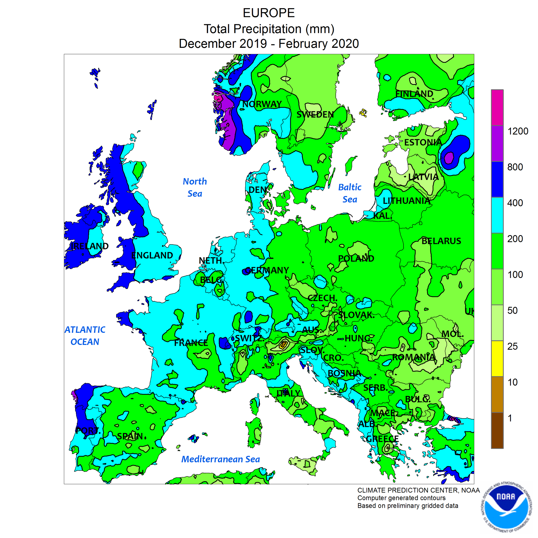
English: Regional climate map: Europe, 3 month precipitation Dec 2019 to February 2020
Deutsch: Regional 3-Monatsniederschlagskarte Europa, Dezember 2019 bis Februar 2020 |
| Date | |
| Source | https://www.cpc.ncep.noaa.gov/products/analysis_monitoring/regional_monitoring/3cpcp1.png |
| Author | CPC. NOAA. |
Licensing
[edit]
This image is in the public domain because it contains materials that originally came from the U.S. National Oceanic and Atmospheric Administration, taken or made as part of an employee's official duties.
|
File history
Click on a date/time to view the file as it appeared at that time.
| Date/Time | Thumbnail | Dimensions | User | Comment | |
|---|---|---|---|---|---|
| current | 21:46, 10 May 2020 | | 2,700 × 2,700 (323 KB) | Matthiasb (talk | contribs) | {{Information |description ={{en|1=Regional climate map: Europe, 3 month precipitation Dec 2019 to February 2020}} {{de|1=Regional 3-Monatsniederschlagskarte Europa, Dezember 2019 bis Februar 2020}} |date =2020-05-10 |source =https://www.cpc.ncep.noaa.gov/products/analysis_monitoring/regional_monitoring/3cpcp1.png |author =CPC. NOAA. }} Category:Climate maps of Europe Category:Rainfall amount maps Category:Winter 2019-2020 in Europe |
You cannot overwrite this file.
File usage on Commons
There are no pages that use this file.