File:20100217005035!A view on 6th to 8th cent.jpg
Jump to navigation
Jump to search
Size of this preview: 688 × 600 pixels. Other resolutions: 275 × 240 pixels | 550 × 480 pixels | 977 × 852 pixels.
Original file (977 × 852 pixels, file size: 98 KB, MIME type: image/jpeg)
Captions
Captions
Add a one-line explanation of what this file represents

|
This historical map image could be re-created using vector graphics as an SVG file. This has several advantages; see Commons:Media for cleanup for more information. If an SVG form of this image is available, please upload it and afterwards replace this template with
{{vector version available|new image name}}.
It is recommended to name the SVG file “20100217005035!A view on 6th to 8th cent.svg”—then the template Vector version available (or Vva) does not need the new image name parameter. |


Summary
[edit]
| Description |
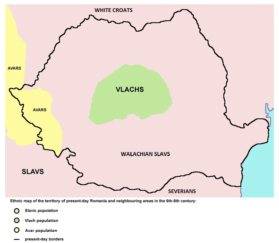
English: Ethnic distribution in the territory of present-day Romania and neighboring areas after the Slav Settlement (8th century) |
| Date | |
| Source |
|
| Author | PANONIAN (it is an older version of File:A view on 6th to 8th century ethnic distribution in Romania.png) |
Licensing
[edit]
| I, the copyright holder of this work, release this work into the public domain. This applies worldwide. In some countries this may not be legally possible; if so: I grant anyone the right to use this work for any purpose, without any conditions, unless such conditions are required by law. |
File history
Click on a date/time to view the file as it appeared at that time.
| Date/Time | Thumbnail | Dimensions | User | Comment | |
|---|---|---|---|---|---|
| current | 10:26, 28 January 2013 | | 977 × 852 (98 KB) | Iaaasi (talk | contribs) | Reverted to version as of 10:21, 28 January 2013 |
| 10:22, 28 January 2013 |  | 977 × 852 (98 KB) | Iaaasi (talk | contribs) | Reverted to version as of 10:20, 28 January 2013 | |
| 10:22, 28 January 2013 |  | 977 × 852 (98 KB) | Iaaasi (talk | contribs) | Reverted to version as of 09:14, 28 January 2013 | |
| 10:21, 28 January 2013 |  | 977 × 852 (98 KB) | Iaaasi (talk | contribs) | Reverted to version as of 10:20, 28 January 2013 | |
| 10:20, 28 January 2013 |  | 977 × 852 (98 KB) | Iaaasi (talk | contribs) | Reverted to version as of 09:14, 28 January 2013 | |
| 10:20, 28 January 2013 |  | 977 × 852 (98 KB) | Iaaasi (talk | contribs) | Reverted to version as of 09:12, 28 January 2013 | |
| 09:14, 28 January 2013 |  | 977 × 852 (98 KB) | Iadrian yu (talk | contribs) | Updated the map to reflect the sources. | |
| 09:12, 28 January 2013 |  | 977 × 852 (98 KB) | Iadrian yu (talk | contribs) | ||
| 07:08, 23 January 2013 |  | 977 × 852 (83 KB) | TheDacian (talk | contribs) | User created page with UploadWizard |
You cannot overwrite this file.
File usage on Commons
There are no pages that use this file.
File usage on other wikis
The following other wikis use this file:
- Usage on es.wikipedia.org
- Usage on it.wikipedia.org
- Usage on ro.wikipedia.org
Categories:
- Avar Khaganate
- Historical maps of ethnic groups in Romania
- Historical maps of ethnic groups in the Balkans
- Maps of Eurasian Avars
- Maps of ethnic groups in Romania
- Maps of the South Slavs
- Maps of the history of Romania in the Middle Ages
- Romania in the 6th century
- Romania in the 7th century
- Romania in the 8th century