File:1985-05-31 tornado outbreak map.PNG
Jump to navigation
Jump to search
No higher resolution available.
1985-05-31_tornado_outbreak_map.PNG (705 × 520 pixels, file size: 141 KB, MIME type: image/png)
Captions
Captions
Add a one-line explanation of what this file represents
Summary
[edit]
| Description |
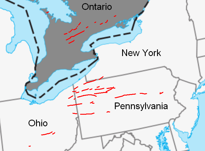
English: Map of tornado tracks in the May 31, 1985 tornado outbreak. Based on this map from Environment Canada, using a cropped version of this Public Domain map. |
| Date | |
| Source | Own work |
| Author | Runningonbrains |
| Permission (Reusing this file) |
Public Domain |
Licensing
[edit]
| I, the copyright holder of this work, release this work into the public domain. This applies worldwide. In some countries this may not be legally possible; if so: I grant anyone the right to use this work for any purpose, without any conditions, unless such conditions are required by law. |
File history
Click on a date/time to view the file as it appeared at that time.
| Date/Time | Thumbnail | Dimensions | User | Comment | |
|---|---|---|---|---|---|
| current | 07:55, 2 June 2010 | | 705 × 520 (141 KB) | Runningonbrains (talk | contribs) | {{Information |Description={{en|1=Map of tornado tracks in the May 31, 1985 tornado outbreak. Based on [http://www.msc.ec.gc.ca/education/teachers_guides/Module01_image_files/track_of_to |
You cannot overwrite this file.
File usage on Commons
There are no pages that use this file.
File usage on other wikis
The following other wikis use this file:
- Usage on en.wikipedia.org
- Usage on fr.wikipedia.org
- Usage on simple.wikipedia.org