File:1976 Helsinki tram map.png
Jump to navigation
Jump to search

Size of this preview: 600 × 600 pixels. Other resolutions: 240 × 240 pixels | 480 × 480 pixels | 768 × 768 pixels | 1,200 × 1,200 pixels.
Original file (1,200 × 1,200 pixels, file size: 111 KB, MIME type: image/png)
Captions
Captions
Add a one-line explanation of what this file represents
Summary
[edit]
| Description |
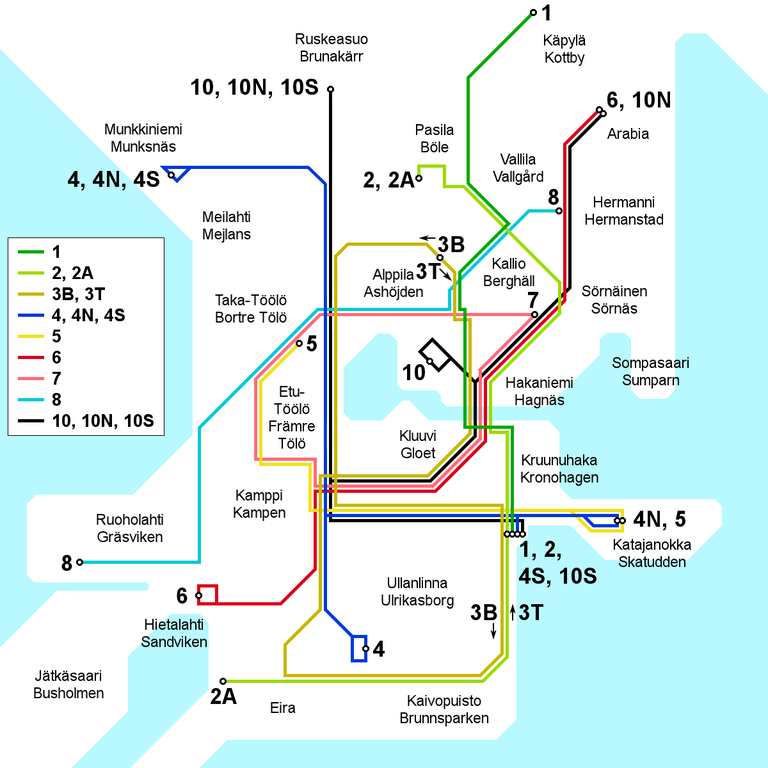
English: Map of the Helsinki tram network as it appeared in 1976 and 1977.
Suomi: Kartta Helsingin raitiotielinjastosta sellaisena kuin se oli vuosina 1976 ja 1977.
Svenska: Karten över Helsingfors spårvägsnätet under år 1976 och 1977. |
| Date | |
| Source | Own work |
| Author | Kalle Id |

|
This transport map image could be re-created using vector graphics as an SVG file. This has several advantages; see Commons:Media for cleanup for more information. If an SVG form of this image is available, please upload it and afterwards replace this template with
{{vector version available|new image name}}.
It is recommended to name the SVG file “1976 Helsinki tram map.svg”—then the template Vector version available (or Vva) does not need the new image name parameter. |
Licensing
[edit]
I, the copyright holder of this work, hereby publish it under the following license:
This file is licensed under the Creative Commons Attribution-Share Alike 3.0 Unported license.
- You are free:
- to share – to copy, distribute and transmit the work
- to remix – to adapt the work
- Under the following conditions:
- attribution – You must give appropriate credit, provide a link to the license, and indicate if changes were made. You may do so in any reasonable manner, but not in any way that suggests the licensor endorses you or your use.
- share alike – If you remix, transform, or build upon the material, you must distribute your contributions under the same or compatible license as the original.
File history
Click on a date/time to view the file as it appeared at that time.
| Date/Time | Thumbnail | Dimensions | User | Comment | |
|---|---|---|---|---|---|
| current | 12:22, 30 June 2010 | | 1,200 × 1,200 (111 KB) | Kjet (talk | contribs) | Improved geographical accuracy, altered line colours to match with other historical maps, bilingual names |
| 17:48, 4 October 2008 |  | 1,200 × 1,200 (76 KB) | Kjet (talk | contribs) | Improved grographical accuracy | |
| 15:50, 17 August 2008 |  | 1,200 × 1,200 (75 KB) | Kjet (talk | contribs) | Improved accuracy. | |
| 18:05, 7 August 2008 |  | 1,200 × 1,200 (76 KB) | Kjet (talk | contribs) | Corrected anachronism in the route of line number 3. | |
| 11:27, 25 July 2008 |  | 1,200 × 1,200 (75 KB) | Kjet (talk | contribs) | {{Information |Description={{en|1=Map of the Helsinki tram network as it appeared between 1976 and 1980. District names in Finnish, a Swedish version can be made on request.}} {{fi|1=Kartta Helsingin raitiotielinjastosta sellaisena kuin se oli vuosien 197 |
You cannot overwrite this file.
File usage on Commons
The following page uses this file:
File usage on other wikis
The following other wikis use this file:
- Usage on en.wikipedia.org
- Usage on fi.wikipedia.org
- Usage on fr.wikipedia.org
- Usage on sv.wikipedia.org
- Usage on uk.wikipedia.org