File:1943 World War II Japanese Aeronautical Map of the Celebes - Geographicus - Celebes13-wwii-1943.jpg

Original file (5,000 × 3,454 pixels, file size: 5.11 MB, MIME type: image/jpeg)
Captions
Captions
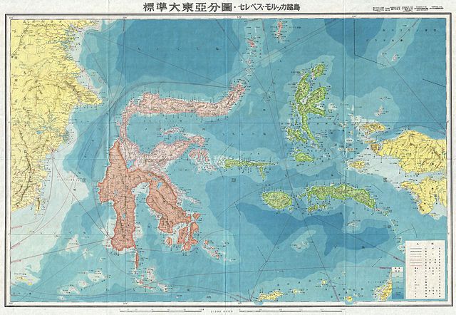
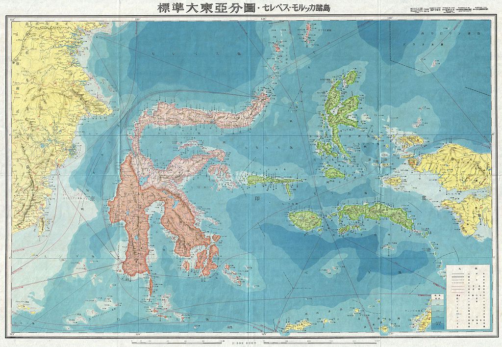
| Celebes. | |||||
|---|---|---|---|---|---|
| Artist | |||||
| Title |
Celebes. |
||||
| Description |
English: A stunning large format Japanese map of Celebes dating to World War II. Covers the entirety of the island and its vicinity with color coding according to area Offers superb detail regarding both topographical and political elements. Notes cities, roads, trade routes on air, sea and land, and uses shading to display oceanic depths. All text in Japanese. While Allied World War II maps of this region are fairly common it is extremely rare to come across their Japanese counterparts. This map was created as map no. 13 of a 20 map series detailing of parts of Asia and the Pacific prepared by the Japanese during World War II. |
||||
| Date | 1943 (undated) | ||||
| Dimensions | height: 20 in (50.8 cm); width: 29 in (73.6 cm) | ||||
| Accession number |
Geographicus link: Celebes13-wwii-1943 |
||||
| Source/Photographer |
|
||||
| Permission (Reusing this file) |
|
||||
| Other versions | |||||

.jpg)
File history
Click on a date/time to view the file as it appeared at that time.
| Date/Time | Thumbnail | Dimensions | User | Comment | |
|---|---|---|---|---|---|
| current | 16:54, 22 March 2011 | | 5,000 × 3,454 (5.11 MB) | BotMultichillT (talk | contribs) | {{subst:User:Multichill/Geographicus |link=http://www.geographicus.com/P/AntiqueMap/Celebes13-wwii-1943 |product_name=1943 World War II Japanese Aeronautical Map of the Celebes |map_title=Celebes. |description=A stunning large format Japanese map of Celeb |
You cannot overwrite this file.
File usage on Commons
The following 2 pages use this file: