File:1921 Railway terminal map of Chicago by Rand McNally.jpg
Jump to navigation
Jump to search

Size of this preview: 446 × 600 pixels. Other resolutions: 178 × 240 pixels | 357 × 480 pixels | 571 × 768 pixels | 761 × 1,024 pixels | 1,523 × 2,048 pixels | 2,800 × 3,765 pixels.
Original file (2,800 × 3,765 pixels, file size: 8.15 MB, MIME type: image/jpeg)
Captions
Captions
Add a one-line explanation of what this file represents
| Title |
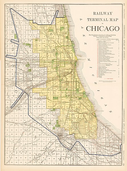
Railway Terminal Map of Chicago |
||||
| Description |
This antique railway map of Chicago was published in the 1921 Edition of Rand McNally’s Indexed Atlas of the World. It is a very detailed representation of Chicago which includes more than just the rail lines that run through the city. The names of the various Chicago neighborhoods and suburbs are noted, as well as prominent streets and landmarks. |
||||
| Date | |||||
| Source | HJB Maps | ||||
| Creator |
Rand McNally |
||||
| Permission (Reusing this file) |
|
||||
| Geotemporal data | |||||
| Date depicted | |||||
| Map location | Chicago | ||||
| Georeferencing | If inappropriate please set warp_status = skip to hide. | ||||
| Bibliographic data | |||||
| Publisher |
Rand McNally |
||||
| Archival data | |||||
| Dimensions | height: 26 in (66 cm); width: 19 in (48.2 cm) | ||||
File history
Click on a date/time to view the file as it appeared at that time.
| Date/Time | Thumbnail | Dimensions | User | Comment | |
|---|---|---|---|---|---|
| current | 22:11, 15 August 2016 | | 2,800 × 3,765 (8.15 MB) | Scewing (talk | contribs) | {{Map |title =Railway Terminal Map of Chicago |description =This antique railway map of Chicago was published in the 1921 Edition of Rand McNally’s Indexed Atlas of the World. It is a very detailed representation of Chicago which in... |
You cannot overwrite this file.
File usage on Commons
The following page uses this file:
File usage on other wikis
The following other wikis use this file:
- Usage on de.wikipedia.org