File:1910 map of Salem tunnel proposal.jpg
Jump to navigation
Jump to search

Size of this preview: 798 × 171 pixels. Other resolutions: 320 × 69 pixels | 640 × 137 pixels | 2,674 × 573 pixels.
Original file (2,674 × 573 pixels, file size: 374 KB, MIME type: image/jpeg)
Captions
Captions
Add a one-line explanation of what this file represents
Summary
[edit]| Description |
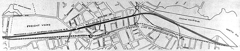
English: A 1910 map of a proposal to build a 4-track tunnel under Salem, part of plans to quad-track and grade-separate the Eastern Route as far as Beverly |
|||
| Date | ||||
| Source | Boston Globe, December 20, 1910 | |||
| Author | Unknown author | |||
| Permission (Reusing this file) |
|

File history
Click on a date/time to view the file as it appeared at that time.
| Date/Time | Thumbnail | Dimensions | User | Comment | |
|---|---|---|---|---|---|
| current | 21:28, 14 March 2020 | 2,674 × 573 (374 KB) | Pi.1415926535 (talk | contribs) | {{Information |description ={{en|1=A 1910 map of a proposal to build a 4-track tunnel under Salem, part of plans to quad-track and grade-separate the Eastern Route as far as Beverly}} |date =1910 |source =[https://www.newspapers.com/clip/46690809/the-boston-globe/ Boston Globe, December 20, 1910] |author ={{unknown|author}} |permission ={{PD-scan|PD-US-expired}} }} Category:1910 maps of Massachusetts Category:Rail transport maps of Massachusetts [[Category... |
You cannot overwrite this file.
File usage on Commons
The following 3 pages use this file: