File:1895 Meiji 28 Japanese Map of Imperial Japan with Taiwan - Geographicus - ImperialJapan-meiji28-1895.jpg
Jump to navigation
Jump to search

Size of this preview: 800 × 570 pixels. Other resolutions: 320 × 228 pixels | 640 × 456 pixels | 1,024 × 730 pixels | 1,280 × 912 pixels | 2,560 × 1,824 pixels | 6,000 × 4,275 pixels.
Original file (6,000 × 4,275 pixels, file size: 6.63 MB, MIME type: image/jpeg)
Captions
Captions
Add a one-line explanation of what this file represents
| Imperial Japan. | ||||||
|---|---|---|---|---|---|---|
| Artist | ||||||
| Title |
Imperial Japan. |
|||||
| Description |
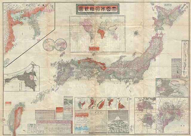
English: An extremely impressive large scale map of the Japanese Empire dating to 1895 or Meiji 28. This map was issued shortly after the 1895 Japanese invasion of Taiwan and is consequently one of the first Japanese maps to include Taiwan and Korea as provinces of Imperial Japan. The map also includes various insets focusing on various Japanese cities and important islands. At the base of the map there are various statistical charts as well as a comparative mountains and rivers chart. At the top center three is a world map showing the various continents with Japan itself highlighted in red. |
|||||
| Date | 1895 (dated) | |||||
| Dimensions | height: 30 in (76.2 cm); width: 42 in (106.6 cm) | |||||
| Accession number |
Geographicus link: ImperialJapan-meiji28-1895 |
|||||
| Source/Photographer |
|
|||||
| Permission (Reusing this file) |
|
|||||
File history
Click on a date/time to view the file as it appeared at that time.
| Date/Time | Thumbnail | Dimensions | User | Comment | |
|---|---|---|---|---|---|
| current | 06:48, 25 March 2011 | | 6,000 × 4,275 (6.63 MB) | BotMultichillT (talk | contribs) | {{subst:User:Multichill/Geographicus |link=http://www.geographicus.com/P/AntiqueMap/ImperialJapan-meiji28-1895 |product_name=1895 Meiji 28 Japanese Map of Imperial Japan with Taiwan |map_title=Imperial Japan. |description=An extremely impressive large sca |
You cannot overwrite this file.
File usage on Commons
The following page uses this file:
File usage on other wikis
The following other wikis use this file:
- Usage on en.wikipedia.org
- Usage on ms.wikipedia.org
- Usage on simple.wikipedia.org
- Usage on vi.wikipedia.org