File:1873 Beers Map of Stony Brook and Port Jefferson, Long Island, New York - Geographicus - StonyBrook-beers-1873.jpg
Jump to navigation
Jump to search
Size of this preview: 800 × 539 pixels. Other resolutions: 320 × 216 pixels | 640 × 431 pixels | 1,024 × 690 pixels | 1,280 × 862 pixels | 2,560 × 1,724 pixels | 5,000 × 3,368 pixels.
Original file (5,000 × 3,368 pixels, file size: 4.55 MB, MIME type: image/jpeg)
Captions
Captions
Add a one-line explanation of what this file represents
| Port Jefferson, Town of Brookhaven, Suffolk Co. - Stony Brook, Town of Brookhaven, Suffolk, Co. | ||||||
|---|---|---|---|---|---|---|
| Artist | ||||||
| Title |
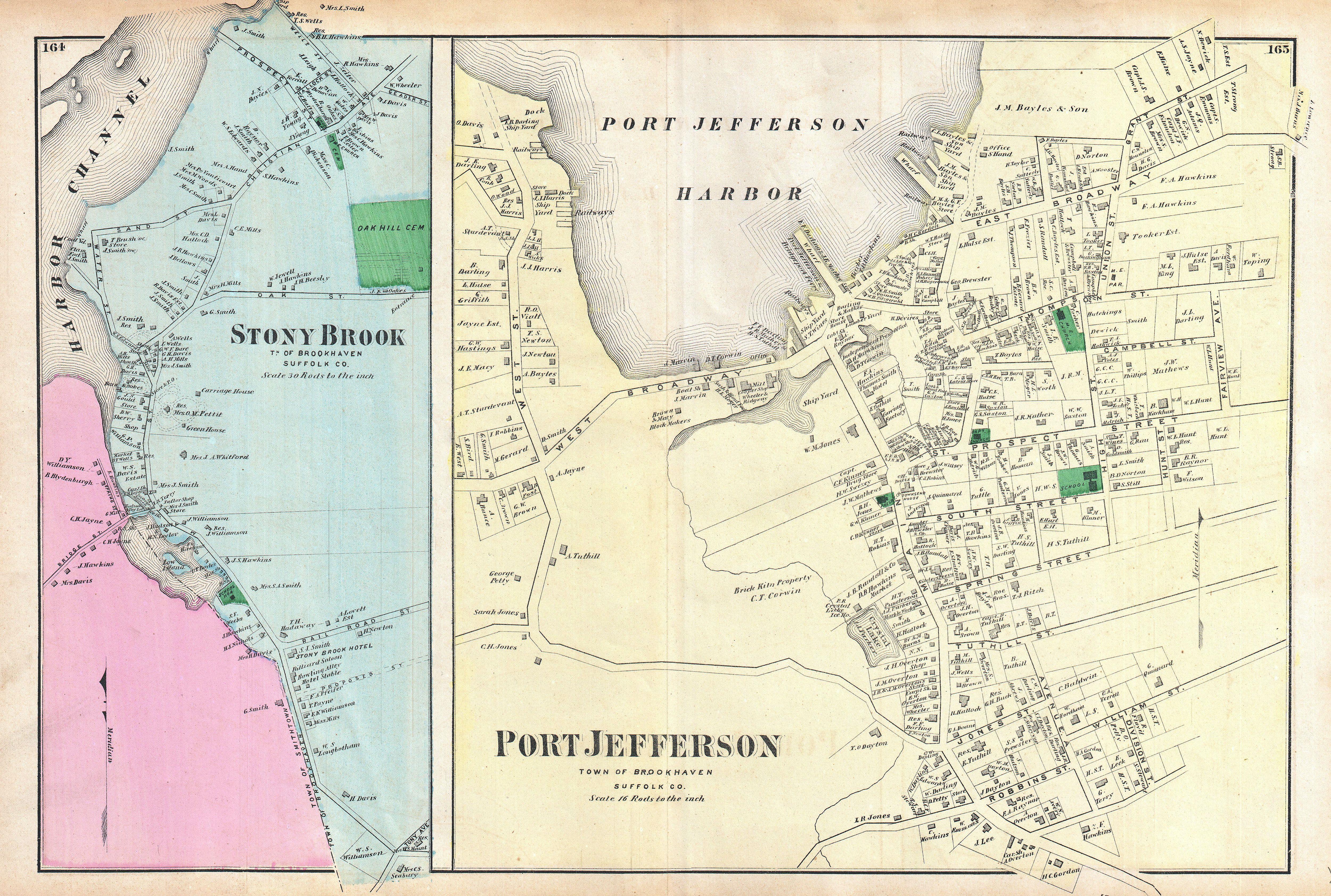
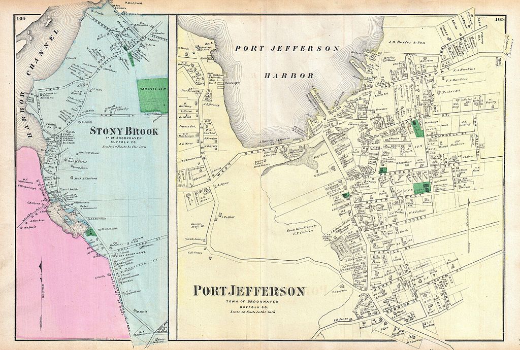
Port Jefferson, Town of Brookhaven, Suffolk Co. - Stony Brook, Town of Brookhaven, Suffolk, Co. |
|||||
| Description |
English: A scarce example of Fredrick W. Beers’ map of Port Jefferson and Stony Brook, Long Island, New York. Published in 1873. Two maps one sheet. Left hand maps depicts the town of Stony Brook from the Harbor Channel to the Oak Hill Cemetery. This area is the home to Stony Brook College. Left hadn side of the map depicts the town of Port Jefferson. Detailed to the level of individual buildings and properties with land holders noted. This is probably the finest atlas map of Stony Brook and Port Jefferson, Long Island to appear in the 19th century. Prepared by Beers, Comstock & Cline out of their office at 36 Vesey Street, New York City, for inclusion in the first published atlas of Long Island, the 1873 issue of Atlas of Long Island, New York. |
|||||
| Date | 1873 (undated) | |||||
| Dimensions | height: 15.5 in (39.3 cm); width: 21.2 in (53.9 cm) | |||||
| Accession number |
Geographicus link: StonyBrook-beers-1873 |
|||||
| Source/Photographer |
Atlas of Long Island, New York. From Recent Actual Surveys and Records Under the Superintendence of F. W. Beers. (1873 First Edition).
|
|||||
| Permission (Reusing this file) |
|
|||||
File history
Click on a date/time to view the file as it appeared at that time.
| Date/Time | Thumbnail | Dimensions | User | Comment | |
|---|---|---|---|---|---|
| current | 18:29, 16 March 2011 | | 5,000 × 3,368 (4.55 MB) | BotMultichill (talk | contribs) | {{subst:User:Multichill/Geographicus |link=http://www.geographicus.com/P/AntiqueMap/StonyBrook-beers-1873 |product_name=1873 Beers Map of Stony Brook and Port Jefferson, Long Island, New York |map_title=Port Jefferson, Town of Brookhaven, Suffolk Co. - St |
You cannot overwrite this file.
File usage on Commons
The following page uses this file: