Category:Beers maps of Long Island published in 1873
Jump to navigation
Jump to search
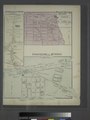
English: Maps from: Atlas of Long Island, New York. From Recent and Actual Surveys and Records Under the Superintendence of F. W. Beers. (New York: Beers, Comstock & Cline, 1873). Comprising title page; table of contents; table of distances for Kings and George Counties; air-line distances for Suffolk County; Brooklyn City business notices (four pages); U. S. statistics (etc.); Flushing and North Side Railroad information (two pages); maps of New York State, Long Island, Manhattan, and the City of Brooklyn; and 97 section maps, including single, double, and multiple pages.
- Online at The New York Public Libray Digital Collections website, Atlas of Long Island….
directories of Brooklyn, Kings County, New York | |||||
| Upload media | |||||
| |||||
Media in category "Beers maps of Long Island published in 1873"
The following 165 files are in this category, out of 165 total.
-

-
 1873 Beers Map of Astoria, Queens, New York City - Geographicus - Astoria-beers-1873.jpg 4,000 × 2,833; 1.81 MB
-

-

-
 1873 Beers Map of Brooklyn, New York - Geographicus - Brooklyn-beers-1873.jpg 5,000 × 3,312; 3.34 MB
-
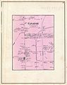 1873 Beers Map of Canarsie, Brooklyn, New York City - Geographicus - Canarsie-beers-1873.jpg 2,377 × 3,000; 1.53 MB
-
-

-
-

-

-

-

-
-

-

-
-

-
 1873 Beers Map of Glen Cove, Queens, New York City - Geographicus - GlenCove-beers-1873.jpg 5,000 × 2,562; 3.04 MB
-

-

-

-

-

-

-
 1873 Beers Map of Jamaica, Queens, New York City - Geographicus - Jamaica-beers-1873.jpg 3,426 × 5,000; 5.29 MB
-

-

-

-
 1873 Beers Map of New York City - Geographicus - NYC-beers-1873.jpg 4,000 × 2,541; 2.01 MB
-
 1873 Beers Map of New York State - Geographicus - NewYork-beers-1873.jpg 4,000 × 2,732; 3.37 MB
-

-

-

-

-

-

-

-
 1873 Beers Map of Patchogue, Long Island, New York - Geographicus - Patchogue-beers-1873.jpg 5,000 × 3,412; 4.03 MB
-

-
-

-

-

-
-

-

-

-

-

-

-

-

-

-

-

-
 1873 Beers Wall Map of Long Island, New York - Geographicus - LongIsland-beers-1873.jpg 7,000 × 1,873; 3.47 MB
-
 1873-Union Course.jpg 1,029 × 941; 215 KB
-
 Air-Line Distances for Suffolk County, Long Island. NYPL1527251.tiff 7,230 × 5,428; 112.31 MB
-
 Amityville, Town of Huntington. NYPL1527326.tiff 5,428 × 7,230; 112.31 MB
-
 Astoria. Part of Long Island City, Town of Newtown, Queens Co. L.I. NYPL1527281.tiff 10,410 × 7,051; 210.03 MB
-
 Atlas of Long Island, New York. From recent and actual surveys and records. NYPL1527248.tiff 5,428 × 7,230; 112.31 MB
-
 Babylon, Suffolk Co. - Commac, Town of Huntington, Suffolk Co. NYPL1527331.tiff 7,140 × 10,170; 207.78 MB
-
 Babylon, Town of Babylon, Suffolk Co. NYPL1527330.tiff 5,428 × 7,230; 112.31 MB
-
 Bayridge. Town of New Utrecht, Kings Co. NYPL1527267.tiff 7,230 × 5,428; 112.31 MB
-

-

-
 Brooklyn City Buisiness Notices. (Continued from page 8.) NYPL1527256.tiff 5,428 × 7,230; 112.31 MB
-
 Brooklyn City Buisiness Notices. (Continued from page 8.) NYPL1527257.tiff 5,428 × 7,230; 112.31 MB
-
 Brooklyn City Buisiness Notices. (Continued from page 8.) NYPL1527258.tiff 5,428 × 7,230; 112.31 MB
-
 Brooklyn City Business Notices. NYPL1527254.tiff 5,428 × 7,230; 112.31 MB
-
 Canarsie. Town of Flat Lands, Kings Co. NYPL1527274.tiff 5,428 × 7,230; 112.31 MB
-

-
 Corona or West Flushing. Tn. of Newtown, Queens Co. NYPL1527285.tiff 5,428 × 7,230; 112.31 MB
-
 Design Map of Sea Cliff Grove, Glen Cove, L.I. NYPL1527320.tiff 10,290 × 7,230; 212.88 MB
-

-
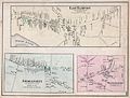
 East Hampton, Suffolk Co. L.I. NYPL1527359.tiff 7,230 × 5,428; 112.31 MB
-

-
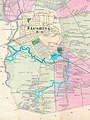
 Far Rockaway, Town of Hempstead. NYPL1527307.tiff 5,428 × 7,230; 112.31 MB
-
 Flatbush, Kings Co. L.I. - East Astoria, part of Long Island City, Queens Co. NYPL1527262.tiff 5,428 × 7,230; 112.31 MB
-
 Flatbush. Town of Flatabush, Kings Co. L.I. - Prospect Park. NYPL1527266.tiff 10,470 × 7,065; 211.66 MB
-
 Flatlands. Kings Co. L.I. NYPL1527273.tiff 5,428 × 7,230; 112.31 MB
-
 Flushing and North Side Railroad, with its leased branches (contd.).) NYPL1527261.tiff 5,428 × 7,230; 112.31 MB
-

-
 FNS back.jpg 2,544 × 3,048; 1.15 MB
-
 FNS front.jpg 2,560 × 3,056; 1.15 MB
-
 FNS map only.jpg 1,160 × 483; 124 KB
-
 Fort Hamilton. Town of New Utrecht, Kings Co. L.I. NYPL1527268.tiff 5,428 × 7,230; 112.31 MB
-
 Freeport NY-1873.jpg 798 × 1,282; 514 KB
-

-
 Glen Cove, Town of Oyster Bay, Queens Co. NYPL1527323.tiff 14,400 × 7,170; 295.42 MB
-
 Greenport, Town of Southold, Suffolk Co. NYPL1527351.tiff 5,428 × 7,230; 112.31 MB
-
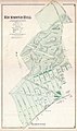
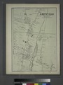
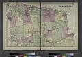
 Hempstead, Town of Hempstead, Queens Co. L.I. NYPL1527304.tiff 10,500 × 7,101; 213.35 MB
-
 Hewletts, Town of Hempstead, Queens Co. - Baldwins, Town of Hempstead, Queens Co. NYPL1527310.tiff 7,230 × 5,428; 112.31 MB
-

-
 Hunters Point. Part of Long Island City. NYPL1527278.tiff 10,470 × 7,044; 211.03 MB
-
 Huntington, Town of Huntington, Suffolk Co. NYPL1527328.tiff 10,260 × 7,110; 208.74 MB
-
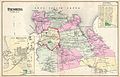
 Islip, Suffolk Co. NYPL1527334.tiff 10,230 × 7,140; 209.01 MB
-
 Islip, Town of Islip, Suffolk Co. NYPL1527333.tiff 7,230 × 5,428; 112.31 MB
-

-
 Jamaica.- Part of Hempstead, Tn. of Hempstead, Queens Co. NYPL1527297.tiff 7,098 × 10,500; 43.46 MB
-
 Kings County Business Notices. (East New York - Flatlands.) NYPL1527288.tiff 5,428 × 7,230; 112.31 MB
-

-
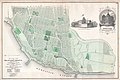
 Map of central portions of the cities of New York and Brooklyn. NYPL1527255.tiff 10,302 × 7,076; 208.59 MB
-
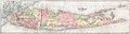
 Map of Long Island. NYPL1527259.tiff 22,410 × 6,345; 403.83 MB
-

-

-
 New Bridge and vicinity, Town of Hempstead, Queens Co. NYPL1527311.tiff 5,428 × 7,230; 112.31 MB
-
 New Lots. Kings Co. L.I. NYPL1527276.tiff 5,428 × 7,230; 112.31 MB
-
 New Utrecht. Kings Co. - Bath, Town on New Utrecht, Kings Co. NYPL1527265.tiff 5,428 × 7,230; 112.31 MB
-
 Newtown, Queens Co. L.I. NYPL1527283.tiff 5,428 × 7,230; 112.31 MB
-
 Newtown, Tn. of Newtown, Queens Co. NYPL1527282.tiff 5,428 × 7,230; 112.31 MB
-
 No.Hemp.2.jpg 1,248 × 1,188; 242 KB
-
 NoHempsteadSection1.jpg 1,210 × 2,162; 2.07 MB
-
 NoHempsteadSection1Subsection1.jpg 766 × 467; 167 KB
-
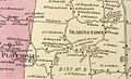
 North Hempstead. - Great Neck, Town of North Hempstead. - Roslyn, Town of Hempstead. NYPL1527315.tiff 10,260 × 7,200; 211.38 MB
-
 North part of Hempstead, Queens Co. L.I. NYPL1527309.tiff 14,220 × 7,050; 286.85 MB
-

-

-
 Oyster Bay, Town of Oyster Bay. NYPL1527317.tiff 10,200 × 7,230; 211.02 MB
-

-
 Part of Brookhaven, Suffolk Co. L.I. NYPL1527337.tiff 10,200 × 7,140; 208.39 MB
-
 Part of Brookhaven, Suffolk Co. NYPL1527340.tiff 10,290 × 7,140; 210.23 MB
-
 Part of College Point, Town of Flushing, Queens Co. NYPL1527287.tiff 10,500 × 7,055; 211.97 MB
-
 Part of College Point. Town of Flushing, Queens Co. NYPL1527290.tiff 10,470 × 7,077; 212.02 MB
-

-
-

-
 Part of Town of Southampton. NYPL1527356.tiff 7,230 × 5,428; 112.31 MB
-
 Queens County Business Notices. (Corona - Hempstead.) NYPL1527291.tiff 5,428 × 7,230; 112.31 MB
-
 Queens County Business Notices. (Flushing - Newtown Village.) NYPL1527289.tiff 5,428 × 7,230; 112.31 MB
-

-
 Queens County Business Notices. - Suffolk County Business Notices. NYPL1527329.tiff 5,428 × 7,230; 112.31 MB
-

-
 Ravenswood. Part of Long Island City. Queens Co. L.I. NYPL1527284.tiff 10,470 × 7,068; 211.75 MB
-
 Richmond Hill. NYPL1527298.tiff 7,080 × 10,440; 211.5 MB
-

-
 Riverhead, Town of Riverhead, Suffolk Co. - Northville, Town of Riverhead, Suffolk Co. NYPL1527352.tiff 10,110 × 7,140; 206.56 MB
-
 Rockville Centre, Hempstead Town, Queens Co. NYPL1527305.tiff 5,428 × 7,230; 112.31 MB
-
 Sag Harbor, Suffolk Co. NYPL1527358.tiff 10,170 × 7,140; 207.78 MB
-
 Sayville, Town of Islip, Suffolk Co. - Bayport, Town of Islip, Suffolk Co. NYPL1527335.tiff 5,428 × 7,230; 112.31 MB
-

-

-
 South part of Hempstead, Queens Co. L.I. NYPL1527312.tiff 14,400 × 7,170; 295.42 MB
-

-

-

-

-
 Southold, Town of Southold, Suffolk Co. - Mattituck, Tn. of Southold, Suffolk Co. NYPL1527353.tiff 10,290 × 7,140; 210.23 MB
-
-

-

-
 Table of Contents. NYPL1527249.tiff 5,428 × 7,230; 112.31 MB
-

-
 The City of Brooklyn. NYPL1527263.tiff 10,470 × 7,098; 212.65 MB
-
 The Flushing and North Side Railroad, with its leased branches. NYPL1527260.tiff 5,428 × 7,230; 112.31 MB
-

-
 UnionClubHouse 1873Beers.jpg 3,632 × 2,928; 14.23 MB
-

-

-

-

-
 Winfield. Tn. of Newtown, Queens Co. NYPL1527279.tiff 5,428 × 7,230; 112.31 MB
-
 Woodhaven, Town of Jamaica, Queens Co. - South Woodhaven, Town of Jamaica, Queens Co. NYPL1527301.tiff 10,470 × 7,080; 212.11 MB
-


_-_Geographicus_-_CollegePoint-beers-1873.jpg)


_-_Geographicus_-_Flatlands-beers-1873.jpg)


,_Queens,_New_York_-_Geographicus_-_HuntersPoint-beers-1873.jpg)


_-_Geographicus_-_NewLots-beers-1873.jpg)
_-_Geographicus_-_Flatlands-beers-1873_(cropped).jpg)


_-_Geographicus_-_RiverheadTown-beers-1873.jpg)

.jpg)


.jpg)


.jpg)
