File:1873 Beers Map of New York City - Geographicus - NYC-beers-1873.jpg
Original file (4,000 × 2,541 pixels, file size: 2.01 MB, MIME type: image/jpeg)
Captions
Captions
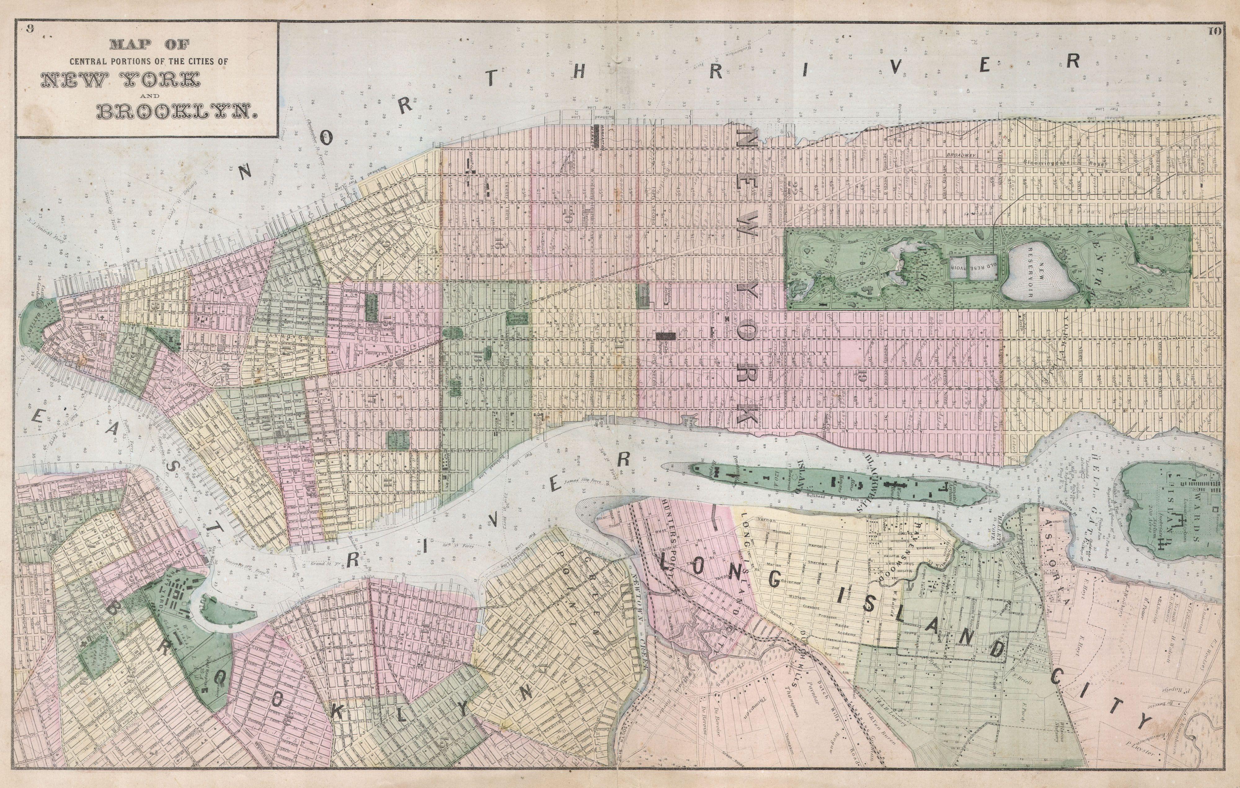
| Map of central portions of the cities of New York and Brooklyn. | ||||||
|---|---|---|---|---|---|---|
| Artist |
Fredrick W. Beer |
|||||
| Title |
Map of central portions of the cities of New York and Brooklyn. |
|||||
| Description |
English: A rare example of Fredrick W. Beers’ Map New York City, New York. Published in 1873, this map depicts New York City to 115th Street and parts of Brooklyn and Queens. Features detail to the street level showing individual buildings, parks, and street names. Offers exceptional detail in Central Park and Queens, areas generally neglected by earlier maps of the city. Blackwood Island ( Roosevelt Island ) is beautifully detailed with a Hospital shown at the southern tip of the Island where today we see only a decrepit, if glorious, ruin. Shows the beginning of the Long Island Railroad at Hunter’s Point and the individual buildings of the Lunatic Asylum on Ward’s Island. Prepared by Beers, Comstock & Cline out of their office at 36 Vesey Street, New York City, for inclusion in the first published atlas of Long Island, the 1873 issue of Atlas of Long Island, New York. |
|||||
| Date | 1873 (undated) | |||||
| Dimensions | height: 14 in (35.5 cm); width: 22.5 in (57.1 cm) | |||||
| Accession number |
Geographicus link: NYC-beers-1873 |
|||||
| Source/Photographer |
Atlas of Long Island, New York. From Recent Actual Surveys and Records Under the Superintendence of F. W. Beers. (1873 First Edition)
|
|||||
| Permission (Reusing this file) |
|
|||||
| Other versions | File:Map of central portions of the cities of New York and Brooklyn. NYPL1527255.tiff | |||||

File history
Click on a date/time to view the file as it appeared at that time.
| Date/Time | Thumbnail | Dimensions | User | Comment | |
|---|---|---|---|---|---|
| current | 13:36, 16 March 2011 | | 4,000 × 2,541 (2.01 MB) | BotMultichill (talk | contribs) | {{subst:User:Multichill/Geographicus |link=http://www.geographicus.com/P/AntiqueMap/NYC-beers-1873 |product_name=1873 Beers Map of New York City |map_title=Map of central portions of the cities of New York and Brooklyn. |description=A rare example of Fred |
You cannot overwrite this file.
File usage on Commons
The following page uses this file:
File usage on other wikis
The following other wikis use this file:
- Usage on en.wikipedia.org