File:1870 U.S. Coast Survey Map Showing Magnetic Declination in the United States - Geographicus - MagneticDeclination-uscs-1870.jpg
Jump to navigation
Jump to search

Size of this preview: 800 × 589 pixels. Other resolutions: 320 × 236 pixels | 640 × 471 pixels | 1,024 × 754 pixels | 1,280 × 943 pixels | 2,560 × 1,886 pixels | 3,000 × 2,210 pixels.
Original file (3,000 × 2,210 pixels, file size: 1.48 MB, MIME type: image/jpeg)
Captions
Captions
Add a one-line explanation of what this file represents
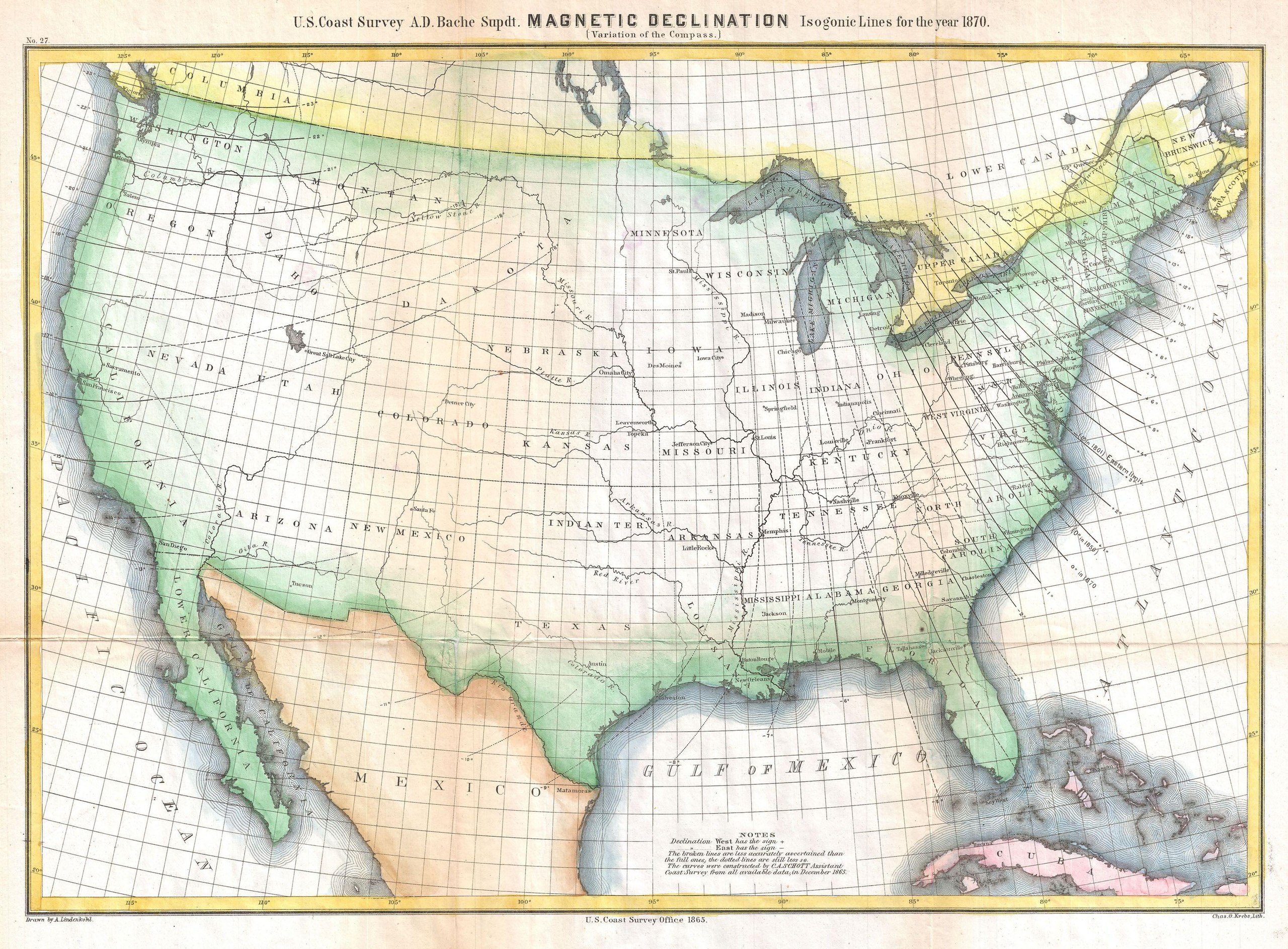
| Magnetic Declination Isogonic Lines for the year 1870 (Variations of the Compass) | ||||||
|---|---|---|---|---|---|---|
| Artist | ||||||
| Title |
Magnetic Declination Isogonic Lines for the year 1870 (Variations of the Compass) |
|||||
| Description |
English: A highly unusual U.S. Coast Survey chart of the United States showing magnetic declination in the year 1870. Magnetic Declination, or as it is more commonly known Magnetic Variance, refers to the difference between true north and compass north. Magnetic variance changes both over time and from place to place, consequently accounting for compass errors was a major obstacle for many early cartographers. Today the magnetic variance in Florida is 0 degrees, but when this chart was made in 1870, the 0 degree point was in South Carolina. A cartographer traveling north from South Carolina to Maine would find that his compass miscalculated north by nearly 18 degrees! In other places the variance is even more extreme. Compiled under the direction of A. D. Bache, Superintendent of the Survey of the Coast of the United States and one of the most influential American cartographers of the 19th century. |
|||||
| Date | 1870 (dated) | |||||
| Dimensions | height: 14.5 in (36.8 cm); width: 20 in (50.8 cm) | |||||
| Accession number |
Geographicus link: MagneticDeclination-uscs-1870 |
|||||
| Source/Photographer |
Report of the Superintendant of the United States Coast Survey, Washington, (1870 edition).
|
|||||
| Permission (Reusing this file) |
|
|||||
File history
Click on a date/time to view the file as it appeared at that time.
| Date/Time | Thumbnail | Dimensions | User | Comment | |
|---|---|---|---|---|---|
| current | 00:15, 24 March 2011 | | 3,000 × 2,210 (1.48 MB) | BotMultichillT (talk | contribs) | {{subst:User:Multichill/Geographicus |link=http://www.geographicus.com/P/AntiqueMap/MagneticDeclination-uscs-1870 |product_name=1870 U.S. Coast Survey Map Showing Magnetic Declination in the United States |map_title=Magnetic Declination Isogonic Lines for |
You cannot overwrite this file.
File usage on Commons
The following page uses this file: