Category:1870 maps of the United States
Jump to navigation
Jump to search
Countries of the Americas: Canada · United States of America
States of the United States: Illinois · Kentucky · Minnesota · New Jersey · New Mexico · New York · Ohio · Pennsylvania · Utah · West Virginia
Subcategories
This category has the following 10 subcategories, out of 10 total.
I
K
- 1870 maps of Kentucky (2 F)
M
- 1870 maps of Minnesota (6 F)
N
- 1870 maps of New Jersey (1 F)
- 1870 maps of New Mexico (empty)
O
- 1870 maps of Ohio (5 F)
P
U
- 1870 maps of Utah (2 F)
W
Media in category "1870 maps of the United States"
The following 11 files are in this category, out of 11 total.
-

-

-
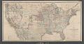
 Map of the United States and territories (NYPL b20883820-5652847).tiff 7,760 × 10,328, 2 pages; 229.61 MB
-
 Map of the United States and territories (NYPL b20883820-5652848).tiff 19,169 × 10,260; 562.97 MB
-
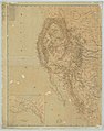
 Lake Court Oreille Indian Lands - NARA - 84786066.jpg 11,463 × 11,053; 7.46 MB
-

-
-
 Military Reservation of Fort Wadsworth.png 1,394 × 2,456; 4.19 MB
-
 Map of the United States and territories (NYPL b20883820-5652845).jpg 7,283 × 9,591; 61.35 MB
-
 Map of the United States and territories (NYPL b20883820-5652846).jpg 7,648 × 9,600; 68.46 MB
-
 Map of the United States and territories (NYPL b20883820-5652847).jpg 7,116 × 9,560; 59.09 MB


.jpg)
.jpg)

.jpg)
.jpg)
.jpg)