File:1865 Spruner Map of the Mediterranean from Pompey to the Battle of Actium - Geographicus - MareInternumPompeii-spruner-1865.jpg
Jump to navigation
Jump to search

Size of this preview: 757 × 599 pixels. Other resolutions: 303 × 240 pixels | 606 × 480 pixels | 970 × 768 pixels | 1,280 × 1,013 pixels | 2,560 × 2,027 pixels | 3,500 × 2,771 pixels.
Original file (3,500 × 2,771 pixels, file size: 2.86 MB, MIME type: image/jpeg)
Captions
Captions
Add a one-line explanation of what this file represents
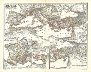
| Karl Spruner von Merz: Mare internum cum populis adiacentibus a Pompeii ex Asia reditu usque ad bellum Actiacum
( |
||||||||||||||||||||
|---|---|---|---|---|---|---|---|---|---|---|---|---|---|---|---|---|---|---|---|---|
| Artist |
|
|||||||||||||||||||
| Title |
Mare internum cum populis adiacentibus a Pompeii ex Asia reditu usque ad bellum Actiacum |
|||||||||||||||||||
| Description |
English: This is Karl von Spruner’s 1865 map, The Mediterranean with Adjacent Peoples from Pompey's Return from Asia to the Battle of Actium (Mare Internum cum populis adiacentibus a Pompeii ex Asia reditu usque ad bellum Actiacum). The map covers the modern day countries of Spain, Italy, Switzerland, Greece, the Balkans, Turkey, and northern Africa. It also features five inserts showing a detailed depiction of France, Turkey, Oriens (or the East), Provincia and Alexandria. Map shows important cities, rivers, mountain ranges and other minor topographical detail. Countries and territories are designated with colored borders and each map includes a key or legend. The whole is rendered in finely engraved detail exhibiting throughout the fine craftsmanship of the Perthes firm. |
|||||||||||||||||||
| Date | 1865 (undated) | |||||||||||||||||||
| Dimensions | height: 13 in (33 cm); width: 16 in (40.6 cm) | |||||||||||||||||||
| Accession number |
Geographicus link: MareInternumPompeii-spruner-1865 |
|||||||||||||||||||
| Source/Photographer |
Spruner, Karl von, Spruner-Menke Atlas Antiquus,, (Gotha: Justus Perthes), 1865.
|
|||||||||||||||||||
| Permission (Reusing this file) |
|
|||||||||||||||||||
File history
Click on a date/time to view the file as it appeared at that time.
| Date/Time | Thumbnail | Dimensions | User | Comment | |
|---|---|---|---|---|---|
| current | 04:43, 25 March 2011 | | 3,500 × 2,771 (2.86 MB) | BotMultichillT (talk | contribs) | {{subst:User:Multichill/Geographicus |link=http://www.geographicus.com/P/AntiqueMap/MareInternumPompeii-spruner-1865 |product_name=1865 Spruner Map of the Mediterranean from Pompey to the Battle of Actium |map_title=Mare internum cum populis adiacentibus |
You cannot overwrite this file.
File usage on Commons
The following page uses this file: