File:1865 Spruner Map of Asia Minor (Turkey) in Antiquity - Geographicus - AsiaMinor-spruner-1865.jpg
Jump to navigation
Jump to search

Size of this preview: 787 × 599 pixels. Other resolutions: 315 × 240 pixels | 630 × 480 pixels | 1,008 × 768 pixels | 1,280 × 975 pixels | 2,560 × 1,950 pixels | 3,500 × 2,666 pixels.
Original file (3,500 × 2,666 pixels, file size: 2.63 MB, MIME type: image/jpeg)
Captions
Captions
Add a one-line explanation of what this file represents
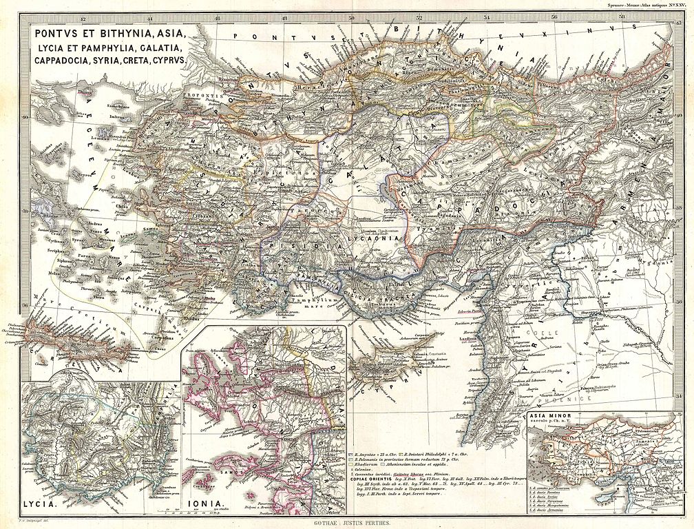
| Karl Spruner von Merz: Pontus et Bithynia, Asia, Lycia et Pamphylia, Galatia, Cappadocia, Syria, Creta, Cyprus.
( |
||||||||||||||||||||
|---|---|---|---|---|---|---|---|---|---|---|---|---|---|---|---|---|---|---|---|---|
| Artist |
|
|||||||||||||||||||
| Title |
Pontus et Bithynia, Asia, Lycia et Pamphylia, Galatia, Cappadocia, Syria, Creta, Cyprus. |
|||||||||||||||||||
| Description |
English: A particularly interesting map, this is Karl von Spruner’s 1865 rendering of Asia Minor in antiquity. This map covers Asia Minor from the Aegean Sea to Armenia and from Cyprus to the Black Sea, including all of modern day Turkey, Cyprus, Lebanon, and Syria. Like most of Spruner’s work this example overlays ancient political geographies on relatively contemporary physical geographies, thus identifying the sites of forgotten towns and villages, the movements of armies, and the disposition of lands in the region. There are three insets in the lower quadrants focusing on the early kingdoms of Lycia and Ionia, as well as a general overview of Asia Minor. As a whole the map labels important cities, rivers, mountain ranges and other minor topographical detail. Territories and countries outlined in color. All text is in Latin. The whole is rendered in finely engraved detail exhibiting the fine craftsmanship for which the Perthes firm is known. Of particular interest to classical scholars. |
|||||||||||||||||||
| Date | 1865 (undated) | |||||||||||||||||||
| Dimensions | height: 13 in (33 cm); width: 16 in (40.6 cm) | |||||||||||||||||||
| Accession number |
Geographicus link: AsiaMinor-spruner-1865 |
|||||||||||||||||||
| Source/Photographer |
Spruner, Karl von, Spruner-Menke Atlas Antiquus,, (Gotha: Justus Perthes), 1865.
|
|||||||||||||||||||
| Permission (Reusing this file) |
|
|||||||||||||||||||
File history
Click on a date/time to view the file as it appeared at that time.
| Date/Time | Thumbnail | Dimensions | User | Comment | |
|---|---|---|---|---|---|
| current | 06:15, 25 March 2011 | | 3,500 × 2,666 (2.63 MB) | BotMultichillT (talk | contribs) | {{subst:User:Multichill/Geographicus |link=http://www.geographicus.com/P/AntiqueMap/AsiaMinor-spruner-1865 |product_name=1865 Spruner Map of Asia Minor (Turkey) in Antiquity |map_title=Pontus et Bithynia, Asia, Lycia et Pamphylia, Galatia, Cappadocia, Syr |
You cannot overwrite this file.
File usage on Commons
The following 2 pages use this file:
_in_Antiquity_-_Geographicus_-_AsiaMinor-spruner-1865.jpg)
_in_Antiquity_-_Geographicus_-_AsiaMinor-spruner-1865_(Lycia_inset_cropped).jpg)
_in_Antiquity_-_Geographicus_-_AsiaMinor-spruner-1865.jpg&oldid=745877409)