File:1862 Stieler Map of Northern Germany - Geographicus - StaatenDeutschen-perthes-1862.jpg
Jump to navigation
Jump to search
Size of this preview: 722 × 599 pixels. Other resolutions: 289 × 240 pixels | 578 × 480 pixels | 925 × 768 pixels | 1,234 × 1,024 pixels | 2,467 × 2,048 pixels | 3,132 × 2,600 pixels.
Original file (3,132 × 2,600 pixels, file size: 1.57 MB, MIME type: image/jpeg)
Captions
Captions
Add a one-line explanation of what this file represents
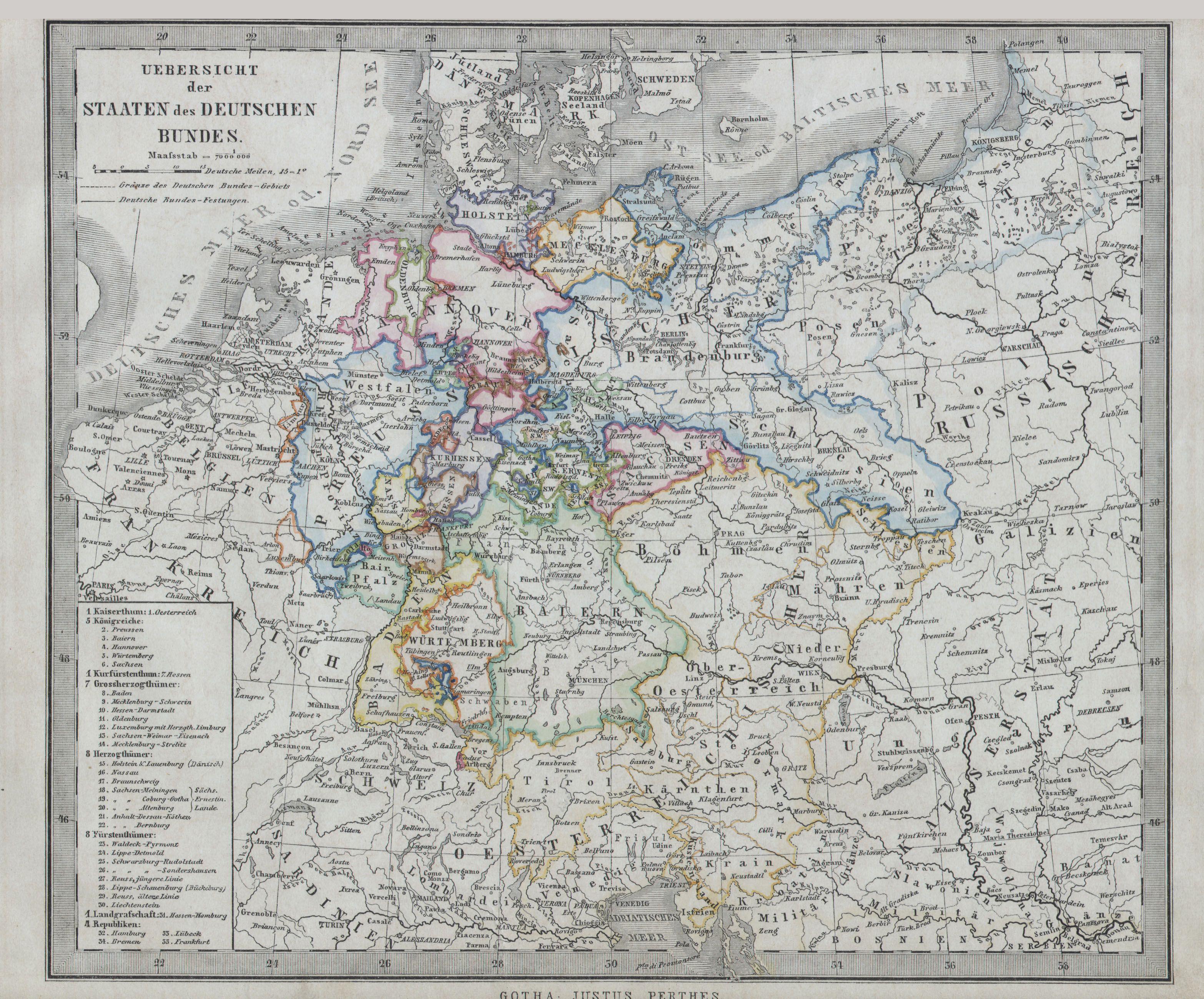
| Uebersicht der Staaten des Deutschen Bundes. | ||||||||||||||||||||||||||||||||||||||||||||||||||
|---|---|---|---|---|---|---|---|---|---|---|---|---|---|---|---|---|---|---|---|---|---|---|---|---|---|---|---|---|---|---|---|---|---|---|---|---|---|---|---|---|---|---|---|---|---|---|---|---|---|---|
| Artist |
|
|||||||||||||||||||||||||||||||||||||||||||||||||
| Title |
Uebersicht der Staaten des Deutschen Bundes. |
|||||||||||||||||||||||||||||||||||||||||||||||||
| Description |
English: This fascinating 1862 map by Adolf Stieler, published by Justus Perthes depicts the north central part of Germany including Hannover, Holstein, Preuss, Baden, Sachsen, Brandenburg and many other states. Unlike other cartographic publishers of the period, the Justus Perthes firm, did not transition to lithographic printing techniques. Instead, all of his maps are copper plate engravings and hence offer a level of character and depth of detail that was impossible to find in lithography or wax-process engraving. All text in German. Issued in the 1862 edition of Stieler’s Schul-Atlas. |
|||||||||||||||||||||||||||||||||||||||||||||||||
| Date | 1862 | |||||||||||||||||||||||||||||||||||||||||||||||||
| Dimensions | height: 8.5 in (21.5 cm); width: 10.5 in (26.6 cm) | |||||||||||||||||||||||||||||||||||||||||||||||||
| Accession number |
Geographicus link: StaatenDeutschen-perthes-1862 |
|||||||||||||||||||||||||||||||||||||||||||||||||
| Source/Photographer |
|
|||||||||||||||||||||||||||||||||||||||||||||||||
| Permission (Reusing this file) |
|
|||||||||||||||||||||||||||||||||||||||||||||||||


File history
Click on a date/time to view the file as it appeared at that time.
| Date/Time | Thumbnail | Dimensions | User | Comment | |
|---|---|---|---|---|---|
| current | 10:29, 16 March 2011 | | 3,132 × 2,600 (1.57 MB) | BotMultichill (talk | contribs) | {{subst:User:Multichill/Geographicus |link=http://www.geographicus.com/P/AntiqueMap/StaatenDeutschen-perthes-1862 |product_name=1862 Stieler Map of Northern Germany |map_title=Uebersicht der Staaten des Deutschen Bundes. |description=This fascinating 18 |
You cannot overwrite this file.
File usage on Commons
The following page uses this file: