File:1862 Physical Map of Central Europe or Deutschland - Geographicus - DeutschlandPhy-perthes-1862.jpg
Jump to navigation
Jump to search

Size of this preview: 743 × 599 pixels. Other resolutions: 298 × 240 pixels | 595 × 480 pixels | 952 × 768 pixels | 1,270 × 1,024 pixels | 2,539 × 2,048 pixels | 3,259 × 2,629 pixels.
Original file (3,259 × 2,629 pixels, file size: 1.87 MB, MIME type: image/jpeg)
Captions
Captions
Add a one-line explanation of what this file represents
Summary
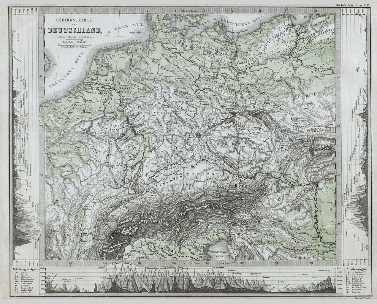
[edit]| Justus Perthes: Gebirgs Karte von Deutschland.
( |
||||||||||||||||||||||||
|---|---|---|---|---|---|---|---|---|---|---|---|---|---|---|---|---|---|---|---|---|---|---|---|---|
| Artist |
|
|||||||||||||||||||||||
| Title |
Gebirgs Karte von Deutschland. |
|||||||||||||||||||||||
| Description |
English: This fascinating 1862 map by Justus Perthes and Stieler depicts the physical geography of central Europe (or as it is called greater Deutschland) from the Adriatic to the Baltic and as far west as Beligum. Cities are noted, but there are not political distinctions. In a display of cartographic flair unique to Perthes maps, a land elevation profiles decorate the bottom and sides of the map. Unlike other cartographic publishers of the period, the Justus Perthes firm, did not transition to lithographic printing techniques. Instead, all of his maps are copper plate engravings and hence offer a level of character and depth of detail that was impossible to find in lithography or wax-process engraving. All text in German. Issued in the 1862 edition of Stieler’s Schul-Atlas. |
|||||||||||||||||||||||
| Date | 1862 | |||||||||||||||||||||||
| Dimensions | height: 8.5 in (21.5 cm); width: 10.5 in (26.6 cm) | |||||||||||||||||||||||
| Accession number |
Geographicus link: DeutschlandPhy-perthes-1862 |
|||||||||||||||||||||||
| Source/Photographer |
|
|||||||||||||||||||||||
| Permission (Reusing this file) |
|
|||||||||||||||||||||||

File history
Click on a date/time to view the file as it appeared at that time.
| Date/Time | Thumbnail | Dimensions | User | Comment | |
|---|---|---|---|---|---|
| current | 10:27, 16 March 2011 | | 3,259 × 2,629 (1.87 MB) | BotMultichill (talk | contribs) | {{subst:User:Multichill/Geographicus |link=http://www.geographicus.com/P/AntiqueMap/DeutschlandPhy-perthes-1862 |product_name=1862 Physical Map of Central Europe or Deutschland |map_title=Gebirgs Karte von Deutschland. |description=This fascinating 1862 |
You cannot overwrite this file.
File usage on Commons
The following page uses this file: