File:1856 U.S. Coast Survey Map of San Francisco Bay and City - Geographicus - SanFrancisco-uscs-1856.jpg
Jump to navigation
Jump to search

Size of this preview: 800 × 439 pixels. Other resolutions: 320 × 176 pixels | 640 × 351 pixels | 1,024 × 562 pixels | 1,280 × 703 pixels | 2,560 × 1,405 pixels | 6,000 × 3,293 pixels.
Original file (6,000 × 3,293 pixels, file size: 3.41 MB, MIME type: image/jpeg)
Captions
Captions
Add a one-line explanation of what this file represents
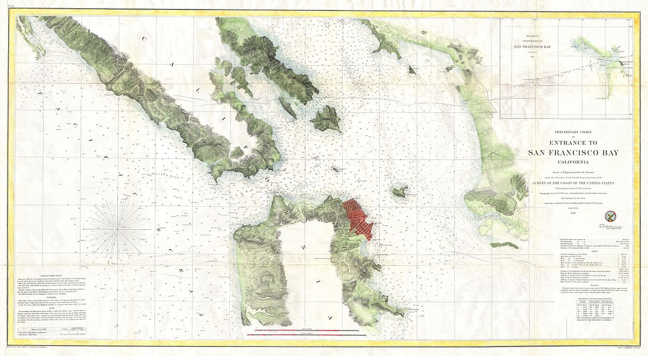
| Preliminary Chart of Entrance to San Francisco Bay California. | ||||||
|---|---|---|---|---|---|---|
| Artist | ||||||
| Title |
Preliminary Chart of Entrance to San Francisco Bay California. |
|||||
| Description |
English: A fine example of the 1856 U.S. Coast Survey chart of San Francisco Bay. Covers the Golden Gate area, the Marin Peninsula, San Francisco, Mission de Dolores, and the eastern coastline from Brooks Island to San Antonio Creek. Offers excellent inland detail noting mountain ranges, fields, swamps, and occasionally individual buildings. The early city layout and grid structure of San Francisco is clear. Thousands of depth soundings throughout. Sailing instructions in the lower left quadrant. Tidal notations in the lower right quadrant. In the upper right quadrant there is a sub-sketch of the entrance to San Francisco Bay. The triangulation for this chart was prepared by R. D CUtts. The topography is the work of R. D. Cutts, A. M Harrison and A. F. Rodgers. They Hydrography was accomplished by a party under the command of James Alden. The entire chart was prepared under the supervision of A.D. Bache, one of the most influential cartographers of his time. |
|||||
| Date | 1856 (dated) | |||||
| Dimensions | height: 20.5 in (52 cm); width: 38 in (96.5 cm) | |||||
| Accession number |
Geographicus link: SanFrancisco-uscs-1856 |
|||||
| Source/Photographer |
Report of the Superintendant of the U.S. Coast Survey, (1856 edition).
|
|||||
| Permission (Reusing this file) |
|
|||||
File history
Click on a date/time to view the file as it appeared at that time.
| Date/Time | Thumbnail | Dimensions | User | Comment | |
|---|---|---|---|---|---|
| current | 15:57, 22 March 2011 | | 6,000 × 3,293 (3.41 MB) | BotMultichillT (talk | contribs) | {{subst:User:Multichill/Geographicus |link=http://www.geographicus.com/P/AntiqueMap/SanFrancisco-uscs-1856 |product_name=1856 U.S. Coast Survey Map of San Francisco Bay and City |map_title=Preliminary Chart of Entrance to San Francisco Bay California. |de |
You cannot overwrite this file.
File usage on Commons
The following page uses this file: