File:1844 Flemming Map of the Eastern Hemisphere - Geographicus - EasternHemi-flemming-1844.jpg

Original file (2,500 × 2,579 pixels, file size: 1.59 MB, MIME type: image/jpeg)
Captions
Captions
| Eastern Hemisphere | ||||||
|---|---|---|---|---|---|---|
| Artist | ||||||
| Title |
Eastern Hemisphere |
|||||
| Description |
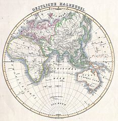
English: This attractive hand colored map depicts the Eastern Hemisphere including Africa, Europe, Asia and Australia. Printed in 1844 by well known map publisher C. Flemming. |
|||||
| Date | 1844 | |||||
| Dimensions | height: 11 in (27.9 cm); width: 11 in (27.9 cm) | |||||
| Accession number |
Geographicus link: EasternHemi-flemming-1844 |
|||||
| Source/Photographer |
|
|||||
| Permission (Reusing this file) |
|
|||||
File history
Click on a date/time to view the file as it appeared at that time.
| Date/Time | Thumbnail | Dimensions | User | Comment | |
|---|---|---|---|---|---|
| current | 07:41, 16 March 2011 | | 2,500 × 2,579 (1.59 MB) | BotMultichill (talk | contribs) | {{subst:User:Multichill/Geographicus |link=http://www.geographicus.com/P/AntiqueMap/EasternHemi-flemming-1844 |product_name=1844 Flemming Map of the Eastern Hemisphere |map_title=Eastern Hemisphere |description=This attractive hand colored map depicts the |
You cannot overwrite this file.
File usage on Commons
The following page uses this file: