File:Map Kingdom of Holland 1807-nl.svg
(Redirected from File:1807koninkrijk holland.svg)

Size of this PNG preview of this SVG file: 505 × 600 pixels. Other resolutions: 202 × 240 pixels | 404 × 480 pixels | 647 × 768 pixels | 862 × 1,024 pixels | 1,725 × 2,048 pixels | 1,902 × 2,258 pixels.
Original file (SVG file, nominally 1,902 × 2,258 pixels, file size: 619 KB)
Captions
Captions
Add a one-line explanation of what this file represents
Summary
[edit]| Description |
[]
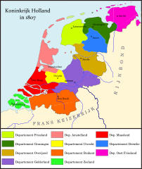
Deutsch: Königreich Holland im Jahr 1807. English: Map of the Kingdom of Holland in 1807 Español: Mapa del Reino de Holanda en 1807 Français : Carte du Royaume de Hollande en 1807 Magyar: A Holland Királyság 1807-ben Nederlands: Kaart van het Koninkrijk Holland Ελληνικά: Χάρτη του Βασιλείου της Ολλανδίας το 1807 |
|||
| Date | ||||
| Source |
Own work
|
|||
| Author | Joostik | |||
| Other versions |
[]
|


Licensing
[edit]
I, the copyright holder of this work, hereby publish it under the following license:
This file is licensed under the Creative Commons Attribution-Share Alike 3.0 Unported license.
- You are free:
- to share – to copy, distribute and transmit the work
- to remix – to adapt the work
- Under the following conditions:
- attribution – You must give appropriate credit, provide a link to the license, and indicate if changes were made. You may do so in any reasonable manner, but not in any way that suggests the licensor endorses you or your use.
- share alike – If you remix, transform, or build upon the material, you must distribute your contributions under the same or compatible license as the original.
File history
Click on a date/time to view the file as it appeared at that time.
| Date/Time | Thumbnail | Dimensions | User | Comment | |
|---|---|---|---|---|---|
| current | 15:40, 10 February 2012 | | 1,902 × 2,258 (619 KB) | Joostik (talk | contribs) |
You cannot overwrite this file.
File usage on Commons
The following 19 pages use this file:
- Atlas of the Netherlands
- File:1807koninkrijk holland.svg (file redirect)
- File:1807koninkrijk holland crop.png
- File:Map Kingdom of Holland 1807-da.svg
- File:Map Kingdom of Holland 1807-de.svg
- File:Map Kingdom of Holland 1807-el.svg
- File:Map Kingdom of Holland 1807-en.svg
- File:Map Kingdom of Holland 1807-es.svg
- File:Map Kingdom of Holland 1807-fr.svg
- File:Map Kingdom of Holland 1807-fy.svg
- File:Map Kingdom of Holland 1807-hu.svg
- File:Map Kingdom of Holland 1807-id.svg
- File:Map Kingdom of Holland 1807-lb.svg
- File:Map Kingdom of Holland 1807-nl.svg
- File:Map Kingdom of Holland 1807-tr.svg
- Template:Other versions/Map Kingdom of Holland 1807
- Category:Kingdom of Holland
- Category:Military of the Kingdom of Holland
File usage on other wikis
The following other wikis use this file:
- Usage on ar.wikipedia.org
- Usage on arz.wikipedia.org
- Usage on ast.wikipedia.org
- Usage on be.wikipedia.org
- Usage on bg.wikipedia.org
- Usage on ca.wikipedia.org
- Usage on cs.wikipedia.org
- Usage on eo.wikipedia.org
- Usage on fa.wikipedia.org
- Usage on fy.wikipedia.org
- Usage on gl.wikipedia.org
- Usage on he.wikipedia.org
- Usage on hr.wikipedia.org
- Usage on it.wikipedia.org
- Usage on ka.wikipedia.org
- Usage on kk.wikipedia.org
- Usage on krc.wikipedia.org
- Usage on li.wikipedia.org
- Usage on mr.wikipedia.org
- Usage on ms.wikipedia.org
- Usage on nds-nl.wikipedia.org
- Usage on nl.wikipedia.org
- Koninkrijk Holland
- Lodewijk Napoleon
- Departementen in de Nederlanden
- Departement Friesland
- Departement Maasland
- Departement Amstelland
- Nederlanders
- Overleg:Platdietse streek
- Departement Overijssel
- Departement Zeeland
- Departement Drenthe
- Departement Gelderland
- Departement Utrecht
- Departement Groningen
- Departement Oost-Friesland
- Departement Brabant
- Usage on pl.wikipedia.org
- Usage on pt.wikipedia.org
- Usage on ro.wikipedia.org
- Usage on ru.wikipedia.org
View more global usage of this file.