File:1794 mapa incendio Nueva Orleans AGI.jpg
Jump to navigation
Jump to search

Size of this preview: 800 × 584 pixels. Other resolutions: 320 × 234 pixels | 640 × 467 pixels | 1,024 × 747 pixels | 1,280 × 934 pixels | 2,096 × 1,530 pixels.
Original file (2,096 × 1,530 pixels, file size: 559 KB, MIME type: image/jpeg)
Captions
Captions
Add a one-line explanation of what this file represents
Summary
[edit]
| Description |
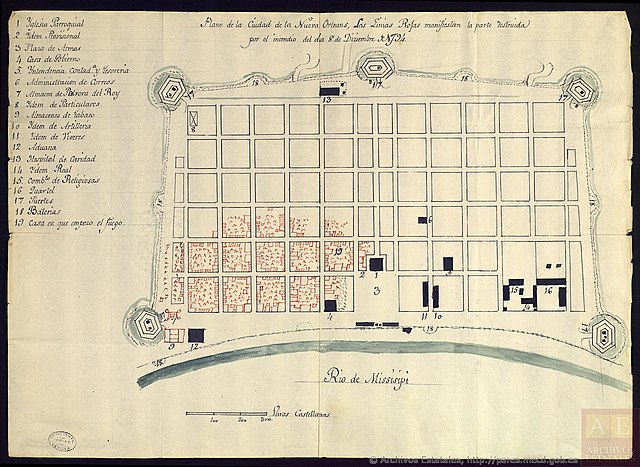
Español: Mapa manuscrito titulado "Plano de la Ciudad de la Nueva Orleans, las Linias Rojas manifiestan la parte destruida por el incendio del dia 8 de Diziembre de 1794".
Conservado en el Archivo General de Indias (Sevilla, España), signatura MP-FLORIDA_LUISIANA,150BIS. Según la ficha del documento, el mapa fue trazado el 11 de diciembre del mismo año.
English: Manuscript map entitled "Plano de la Ciudad de la Nueva Orleans, las Linias Rojas manifiestan la parte destruida por el incendio del dia 8 de Diziembre de 1794", i.e. Plan of the City of New Orleans, the red lines indicate the part destroyed by the fire of 8 December 1794.
Preserved at the Archivo General de Indias (Seville, Spain), MP-FLORIDA_LUISIANA,150BIS. According to the Archive's catalogue, the map was drawn on 11 December 1794. |
| Date | |
| Source | Archivo General de Indias (Sevilla, España) |
| Author | Anónimo, 1794 |
Licensing
[edit]
|
This is a faithful photographic reproduction of a two-dimensional, public domain work of art. The work of art itself is in the public domain for the following reason:
The official position taken by the Wikimedia Foundation is that "faithful reproductions of two-dimensional public domain works of art are public domain".
This photographic reproduction is therefore also considered to be in the public domain in the United States. In other jurisdictions, re-use of this content may be restricted; see Reuse of PD-Art photographs for details. | ||||
File history
Click on a date/time to view the file as it appeared at that time.
| Date/Time | Thumbnail | Dimensions | User | Comment | |
|---|---|---|---|---|---|
| current | 23:29, 23 November 2018 | | 2,096 × 1,530 (559 KB) | Hispalois (talk | contribs) | User created page with UploadWizard |
You cannot overwrite this file.
File usage on Commons
There are no pages that use this file.
File usage on other wikis
The following other wikis use this file:
- Usage on en.wikipedia.org
- Usage on es.wikipedia.org
- Usage on fr.wikipedia.org
Metadata
Categories:
- Old maps of the French Quarter
- 1794 maps of the United States
- Spanish-language maps
- Manuscript maps
- 1794 in New Orleans
- Fires in New Orleans
- Maps and documents in the Archivo General de Indias
- New Orleans in the 1790s
- 1794-12-11
- 1790s maps of Louisiana
- Old maps of Spanish Louisiana
- 1794 fires
- Fires in the United States in the 1790s
- 1794-12-08
- Maps of fires in the United States
- 1794 works in Spain
- 18th-century works in Andalusia
- December 1794 events