Category:Maps and documents in the Archivo General de Indias
Jump to navigation
Jump to search
Subcategories
This category has only the following subcategory.
T
Media in category "Maps and documents in the Archivo General de Indias"
The following 59 files are in this category, out of 59 total.
-

-
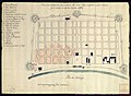 1794 mapa incendio Nueva Orleans AGI.jpg 2,096 × 1,530; 559 KB
-
 Aumento de fuerzas navales inglesas en Río de la Plata.pdf 1,241 × 1,754, 12 pages; 1.87 MB
-
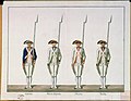
 Bandera del Regimiento de la Corona de Nueva España, 1769.jpg 395 × 634; 17 KB
-
 Biaknabato.jpg 887 × 563; 136 KB
-
 Capitulaciones de Santa Fe, Archivo General de Indias.jpg 3,088 × 4,112; 8.01 MB
-
 Catedral de Cartagena de Indias-Plano de la Capilla Mayor.jpg 1,076 × 1,478; 516 KB
-
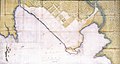
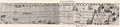 Chile Araucania Map 1610.jpg 2,505 × 555; 403 KB
-
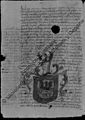
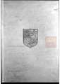
 Coat of Arms of the Province of Louisiana.jpg 800 × 664; 265 KB
-
-
 Croquis del hospital de Natchez.jpg 2,480 × 1,583; 721 KB
-
-

-

-
-

-
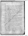
 Documento original sobre la espedición de Magallanes.jpg 1,230 × 1,660; 383 KB
-
 Documento registro Melchor de Alavés.jpg 6,119 × 7,651; 8.97 MB
-
 Elevacion de la Real Casa de Moneda en Santiago de Chile, por Toesca.jpg 986 × 528; 119 KB
-
 Exiliadoshongkong.jpg 854 × 599; 194 KB
-

-

-
 Gujin xingsheng zhi tu.png 1,028 × 1,163; 1.54 MB
-

-
 Información secreta del Capitán Fernando de Lara, ciudad de Gracias a Dios.jpg 880 × 1,242; 340 KB
-
 Libro copiador de Colon completo.pdf 1,241 × 1,754, 78 pages; 18.88 MB
-
 Map of Luzon, Isla Hermosa (Taiwan), and a Part of the Coast of China, 1597.jpg 1,000 × 1,049; 451 KB
-
 Map of the north of the island of Formosa 1626-1642.jpg 720 × 990; 118 KB
-
 Map of the Spanish Port in Jilong, Taiwan, 1626.jpg 1,000 × 1,391; 554 KB
-
 Mapa de Buenos Aires 1713.jpg 706 × 590; 249 KB
-
 Mapa del Curato de Santa Ana.png 6,542 × 4,000; 22.55 MB
-

-

-
 Motul Yucatan 1581.png 552 × 787; 258 KB
-
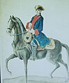 OFICIAL DEL REGIMIENTO DE DRAGONES DE MÉXICO, 1764-1795.jpg 561 × 677; 29 KB
-
 PARES poblar PISCO 1575 bno2.pdf 1,275 × 1,650; 861 KB
-

-
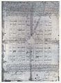
 Pintura de las tierras, pantanos y anegadizos de Bogotá.jpg 2,586 × 2,102; 1.15 MB
-

-

-
 Plan of early fort at St. Augustine.jpg 1,206 × 947; 158 KB
-

-
 Plan of the City of Caracas with its Division in Neighborhoods. 1775.jpg 824 × 1,173; 348 KB
-
-

-
 Plano del actual Hospital Militar.jpg 2,100 × 3,200; 1.2 MB
-
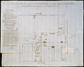
 Plano del grande hospital destinado a el presente para cuarteles.jpg 2,348 × 1,840; 609 KB
-
 Plano del Sitio de la Florida 1740.jpg 2,636 × 1,592; 2.23 MB
-
 Plano Fuerte San Antonio de la Eminencia, 1688.jpg 687 × 996; 128 KB
-
 Planos de la Plaza Mayor de la Muy Noble y Muy Leal Ciudad de Panamá 1748.jpg 1,600 × 1,048; 739 KB
-
 Planta del hospital de San Marcos de Apalache.jpg 2,412 × 1,599; 720 KB
-
 Rasguño de las provincias de la Nueva México LOC 2010585450.jpg 6,862 × 4,884; 3.79 MB
-
 Rasguño de las provincias de la Nueva México LOC 2010585450.tiff 6,862 × 4,884; 95.88 MB
-
 Recopilación de Leyes de los Reynos de las Indias, Archivo General de Indias.jpg 2,742 × 3,750; 5.59 MB
-
 Sevilla2005Julio 156.jpg 1,200 × 900; 301 KB
-
 Spanish dollar 1776.JPG 2,127 × 1,428; 1.31 MB
-

-
 Traza de la segunda fundación de Mendoza, 1562.jpg 710 × 984; 261 KB
-
 Traza fundacional de Mendoza, 1561.jpg 758 × 1,037; 264 KB


_de_la_Ciudad_de_Panam%C3%A1_y_el_sitio_donde_est%C3%A1n_las_Casas_Reales_y_la_Ysla_de_Perico_y_las_dem%C3%A1s_Yslas%E2%80%99.jpg)


.jpg)


,_and_a_Part_of_the_Coast_of_China,_1597.jpg)


.jpg)


.jpg)


.jpg)