File:1772 Vaugondy - Diderot Map of Asia and the Northeast Passage - Geographicus - NordEstAsie-vaugondy-1772.jpg
Jump to navigation
Jump to search
Size of this preview: 737 × 600 pixels. Other resolutions: 295 × 240 pixels | 590 × 480 pixels | 944 × 768 pixels | 1,258 × 1,024 pixels | 2,517 × 2,048 pixels | 4,000 × 3,255 pixels.
Original file (4,000 × 3,255 pixels, file size: 2.21 MB, MIME type: image/jpeg)
Captions
Captions
Add a one-line explanation of what this file represents
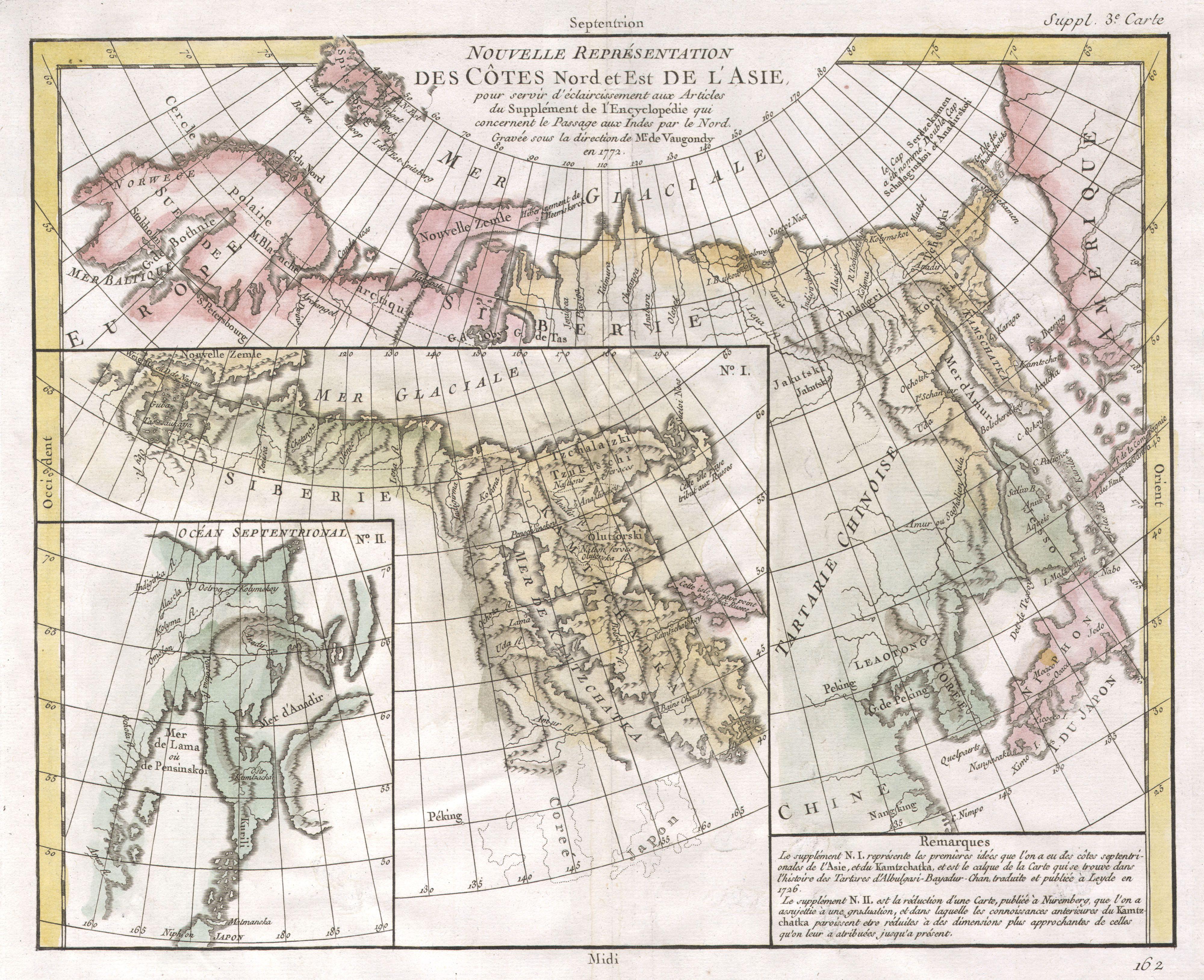
| Nouvelle représentation Des Côtes Nord et Est de l'Asie : pour servir d'éclaircissement aux Articles du Supplement de L'Encyclopedie qui concernent le passage aux Indes par le Nord. | ||||||
|---|---|---|---|---|---|---|
| Artist | ||||||
| Title |
Nouvelle représentation Des Côtes Nord et Est de l'Asie : pour servir d'éclaircissement aux Articles du Supplement de L'Encyclopedie qui concernent le passage aux Indes par le Nord. |
|||||
| Description |
English: A comparative map of the three conflicting theories on the Northeast Passage, the northeast coasts of Asia, and the American Northwest. The Northeast Passage, much like American’s Northwest Passage, was a long sought after sea route through the Arctic that would save European merchantman the expense of rounding Africa in order to access the trade riches of East Asia. This map, in one of the first obtainable examples of comparative cartography, lays out three theories regarding the Northeast of Asia. Knowledge of this area was, at the time, speculative at best. Shows many unknown island, misshapen representations of Kamtschaka, Japan, Hokkaido (Yesso), Alaska, and the Behring Archipelago. Notes Peking (Beijing), Nanking (Nanjing), Corea (Korea), Jedo (Tokyo)and Nangasaki (Nagasaki). This map is part of the 10 map series prepared by Vaugondy for the Supplement to Diderot’s Encyclopédie , of which this is plate 3. This seminal map series, exploring the mapping of North American and specifically the Northwest Passage was one of the first studies in comparative cartography. |
|||||
| Date | 1772 (dated) | |||||
| Dimensions | height: 12 in (30.4 cm); width: 15 in (38.1 cm) | |||||
| Accession number |
Geographicus link: NordEstAsie-vaugondy-1772 |
|||||
| Source/Photographer |
Supplement to Diderot's Encyclopédie, ou dictionnaire raisonné des sciences, des arts et des métiers..
|
|||||
| Permission (Reusing this file) |
|
|||||
File history
Click on a date/time to view the file as it appeared at that time.
| Date/Time | Thumbnail | Dimensions | User | Comment | |
|---|---|---|---|---|---|
| current | 15:50, 16 March 2011 | | 4,000 × 3,255 (2.21 MB) | BotMultichill (talk | contribs) | {{subst:User:Multichill/Geographicus |link=http://www.geographicus.com/P/AntiqueMap/NordEstAsie-vaugondy-1772 |product_name=1772 Vaugondy - Diderot Map of Asia and the Northeast Passage |map_title=Nouvelle représentation Des Côtes Nord et Est de l'Asie |
You cannot overwrite this file.
File usage on Commons
The following page uses this file: