File:1771 Bonne Map of the New Testament Lands, w- Holy Land and Jerusalem - Geographicus - NewTestament-bonne-1771.jpg
Jump to navigation
Jump to search
Size of this preview: 800 × 556 pixels. Other resolutions: 320 × 222 pixels | 640 × 445 pixels | 1,024 × 712 pixels | 1,280 × 889 pixels | 2,560 × 1,779 pixels | 3,500 × 2,432 pixels.
Original file (3,500 × 2,432 pixels, file size: 2.06 MB, MIME type: image/jpeg)
Captions
Captions
Add a one-line explanation of what this file represents
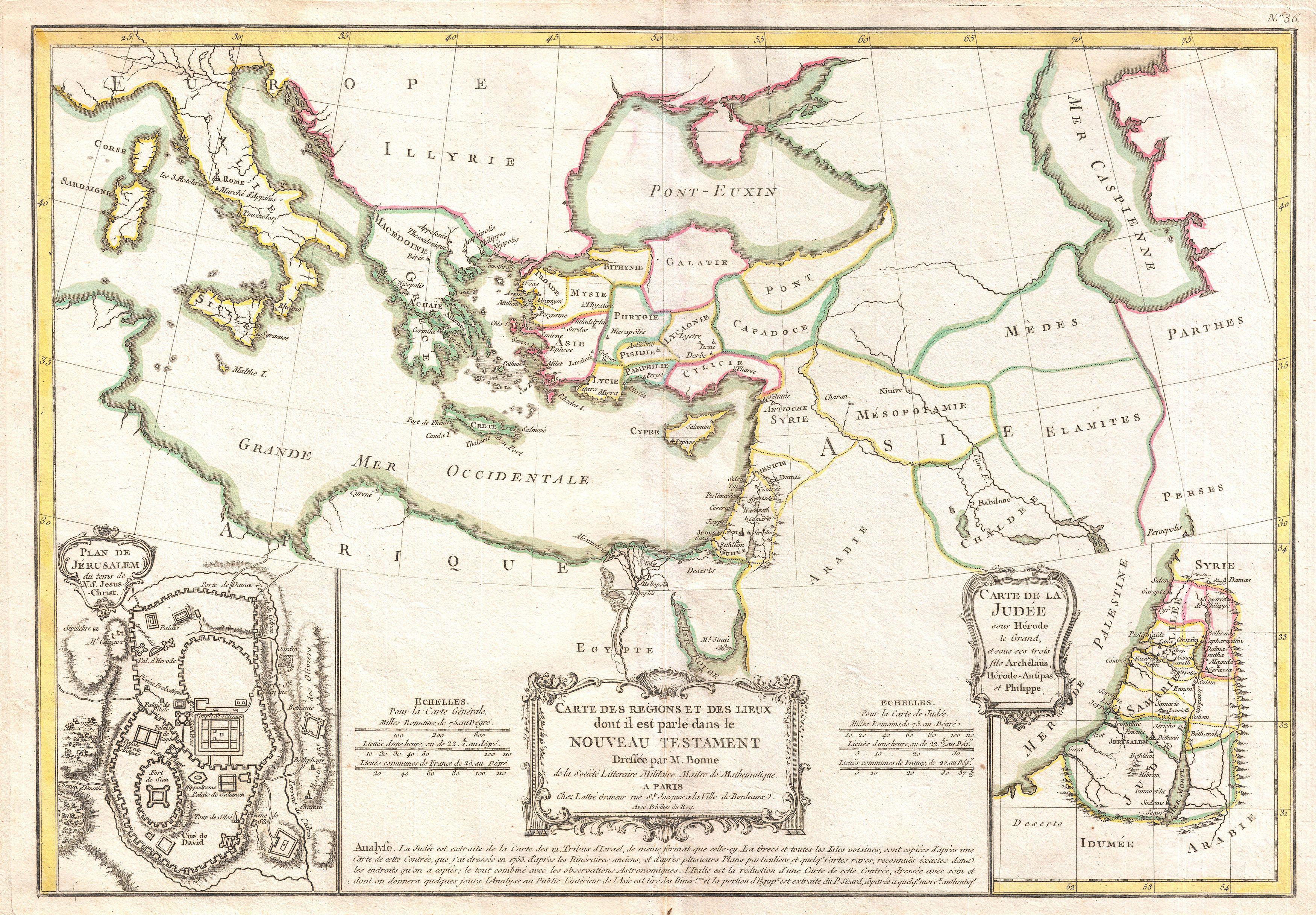
| Rigobert Bonne: Carte des Regions et des Lieux dont il est parle dans le Nouveau Testament.
( |
|||||||||||||||||||||||
|---|---|---|---|---|---|---|---|---|---|---|---|---|---|---|---|---|---|---|---|---|---|---|---|
| Artist |
|
||||||||||||||||||||||
| Title |
Carte des Regions et des Lieux dont il est parle dans le Nouveau Testament. |
||||||||||||||||||||||
| Description |
English: A beautiful example of Rigobert Bonne's 1771 decorative map of the lands of the Bible's New Testament. Covers from Italy eastward to include the Eastern Mediterranean, parts of Africa, Egypt, Persia, Arabia and Asia Minor. Includes both the Blank Sea (Pont-Euxin) and the Caspian Sea (Mer Caspienne). Numerous Biblical sites noted throughout. An inset in the lower left quadrant details the city of Jerusalem in the times of Jesus Christ. Notes the Temple, the Fort of Sion, and the Palace of Solomon, the Mount of Olives, etc. A second inset in the lower right quadrant focuses on Judea under the Biblical King Herod. A decorative baroque title cartouche appears at the bottom center. Drawn by R. Bonne in 1771 for issue as plate no. A 20 in Jean Lattre's 1776 issue of the Atlas Moderne . |
||||||||||||||||||||||
| Date | 1771 (undated) | ||||||||||||||||||||||
| Dimensions | height: 12.5 in (31.7 cm); width: 17.5 in (44.4 cm) | ||||||||||||||||||||||
| Accession number |
Geographicus link: NewTestament-bonne-1771 |
||||||||||||||||||||||
| Source/Photographer |
Lattre, Jean, Atlas Moderne ou Collection de Cartes sur Toutes les Parties du Globe Terrestre, c. 1775.
|
||||||||||||||||||||||
| Permission (Reusing this file) |
|
||||||||||||||||||||||
File history
Click on a date/time to view the file as it appeared at that time.
| Date/Time | Thumbnail | Dimensions | User | Comment | |
|---|---|---|---|---|---|
| current | 03:55, 23 March 2011 | | 3,500 × 2,432 (2.06 MB) | BotMultichillT (talk | contribs) | {{subst:User:Multichill/Geographicus |link=http://www.geographicus.com/P/AntiqueMap/NewTestament-bonne-1771 |product_name=1771 Bonne Map of the New Testament Lands, w- Holy Land and Jerusalem |map_title=Carte des Regions et des Lieux dont il est parle dan |
You cannot overwrite this file.
File usage on Commons
The following page uses this file: