File:1771 Bonne Map of Turkey, Syria and Iraq - Geographicus - Turkey-bone-1771.jpg
Jump to navigation
Jump to search
Size of this preview: 800 × 556 pixels. Other resolutions: 320 × 222 pixels | 640 × 445 pixels | 1,024 × 712 pixels | 1,280 × 889 pixels | 2,560 × 1,779 pixels | 3,500 × 2,432 pixels.
Original file (3,500 × 2,432 pixels, file size: 2.34 MB, MIME type: image/jpeg)
Captions
Captions
Add a one-line explanation of what this file represents
Summary
[edit]
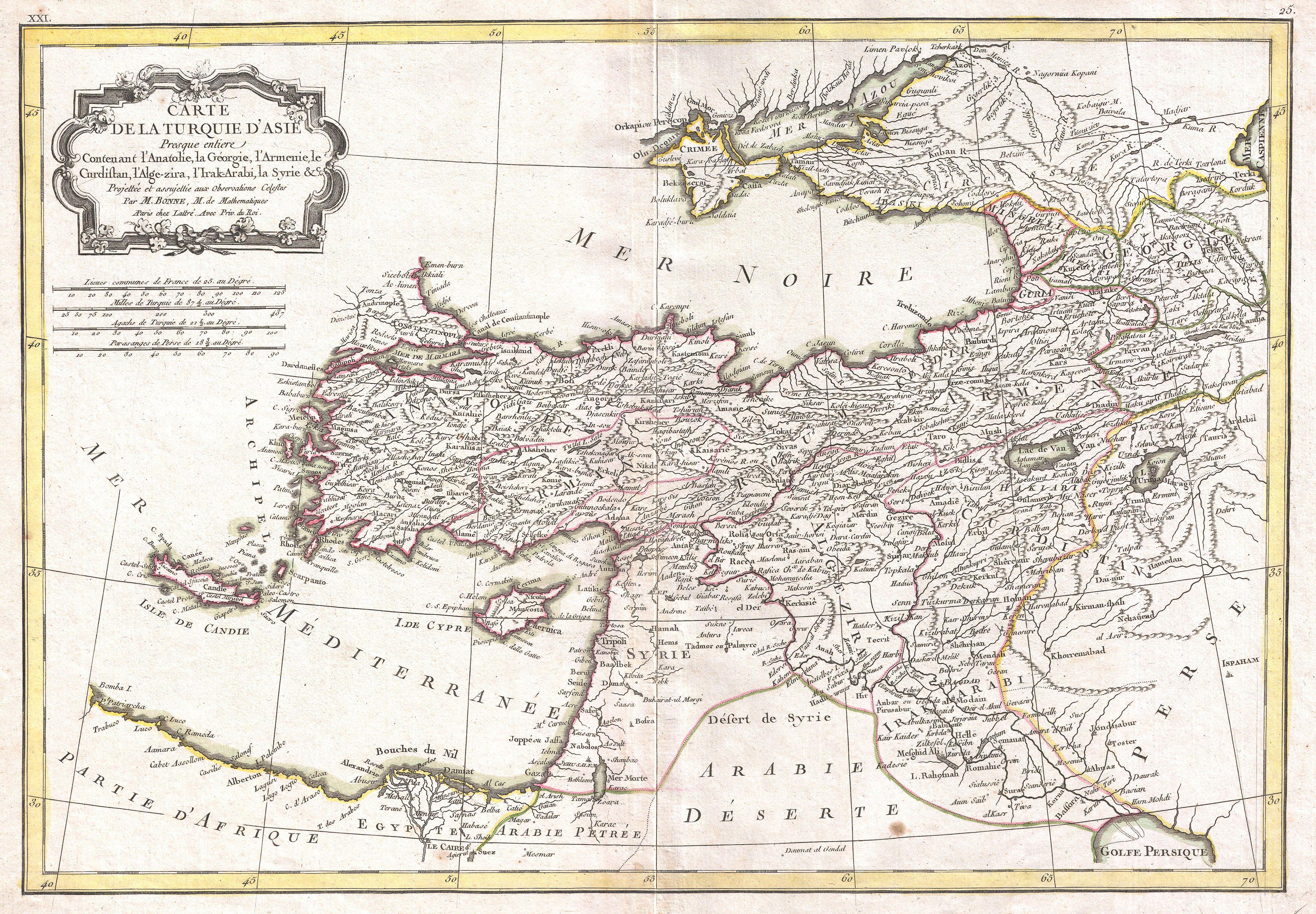
| Rigobert Bonne: Carte de la Turquie D'Asie Presque entiere Contenant L'Anatolie, La Georgie,L'Armenie, Le Curdistan, L'Alge-zira, L'Irak-Arabi, La Syrie & c.
( |
||||||||||||||||||||
|---|---|---|---|---|---|---|---|---|---|---|---|---|---|---|---|---|---|---|---|---|
| Artist |
|
|||||||||||||||||||
| Title |
Carte de la Turquie D'Asie Presque entiere Contenant L'Anatolie, La Georgie,L'Armenie, Le Curdistan, L'Alge-zira, L'Irak-Arabi, La Syrie & c. |
|||||||||||||||||||
| Description |
English: A beautiful example of Rigobert Bonne's 1771 decorative map of Turkey in Asia. Covers from Egypt north to Crimea and from Crete and the Dardanelles east to the Persian Gulf and Georgia. Includes the modern day nations of Turkey, Syria, Cyprus, Iraq, Israel, Jordan, Lebanon, Kuwait, Armenia, Georgia, Azerbaijan and Ukraine. Also notes the disputed lands of Armenia and Kurdistan. Remarkably, this map actually shows the notes but stunning Armenian church on Lake Van's Akdamar Island. A decorative baroque title cartouche appears in the upper left quadrant. Drawn by R. Bonne in 1771 for issue as plate no. 25 in Jean Lattre's 1776 issue of the Atlas Moderne .
العربية: مثال جميل على خريطة ريجوبرت بون الزخرفية 1771 لتركيا في آسيا. تغطي من مصر شمالًا إلى شبه جزيرة القرم ومن كريت والدردنيل شرقاً إلى الخليج الفارسي وجورجيا. وتشمل الدول الحديثة في تركيا وسوريا وقبرص والعراق وإسرائيل والأردن ولبنان والكويت وأرمينيا وجورجيا وأذربيجان وأوكرانيا. وتوضح أيضا الأراضي المتنازع عليها في أرمينيا وكردستان. من المثير للاهتمام أن هذه الخريطة تُظهر الملاحظات لكن الكنيسة الأرمنية المذهلة في جزيرة بحيرة فان أكدامار. تظهر خرطوشة عنوان الباروك الزخرفية في الربع العلوي الأيسر. رسمها R. Bonne في عام 1771 لإصدار اللوحة رقم. 25 في عدد جان لاتر 1776 من أطلس مودرن. |
|||||||||||||||||||
| Date | 1771 (undated) | |||||||||||||||||||
| Dimensions | height: 12.5 in (31.7 cm); width: 17.5 in (44.4 cm) | |||||||||||||||||||
| Accession number |
Geographicus link: Turkey-bone-1771 |
|||||||||||||||||||
| Source/Photographer |
Lattre, Jean, Atlas Moderne ou Collection de Cartes sur Toutes les Parties du Globe Terrestre, c. 1775.
|
|||||||||||||||||||
| Permission (Reusing this file) |
|
|||||||||||||||||||
Licensing
[edit]
|
This is a faithful photographic reproduction of a two-dimensional, public domain work of art. The work of art itself is in the public domain for the following reason:
The official position taken by the Wikimedia Foundation is that "faithful reproductions of two-dimensional public domain works of art are public domain".
This photographic reproduction is therefore also considered to be in the public domain in the United States. In other jurisdictions, re-use of this content may be restricted; see Reuse of PD-Art photographs for details. | ||||
File history
Click on a date/time to view the file as it appeared at that time.
| Date/Time | Thumbnail | Dimensions | User | Comment | |
|---|---|---|---|---|---|
| current | 03:50, 23 March 2011 | | 3,500 × 2,432 (2.34 MB) | BotMultichillT (talk | contribs) | {{subst:User:Multichill/Geographicus |link=http://www.geographicus.com/P/AntiqueMap/Turkey-bone-1771 |product_name=1771 Bonne Map of Turkey, Syria and Iraq |map_title=Carte de la Turquie D'Asie Presque entiere Contenant L'Anatolie, La Georgie,L'Armenie, L |
You cannot overwrite this file.
File usage on Commons
The following page uses this file:
File usage on other wikis
The following other wikis use this file:
- Usage on ar.wikipedia.org
- Usage on en.wikipedia.org
- Usage on it.wikipedia.org
- Usage on ko.wikipedia.org
- Usage on tr.wikipedia.org