File:1771 Bonne Map of Picardy, Artois and French Flanders, France - Geographicus - Picardie-bonne-1771.jpg
Jump to navigation
Jump to search
Size of this preview: 800 × 585 pixels. Other resolutions: 320 × 234 pixels | 640 × 468 pixels | 1,024 × 748 pixels | 1,280 × 935 pixels | 2,560 × 1,871 pixels | 3,500 × 2,558 pixels.
Original file (3,500 × 2,558 pixels, file size: 2.6 MB, MIME type: image/jpeg)
Captions
Captions
Add a one-line explanation of what this file represents
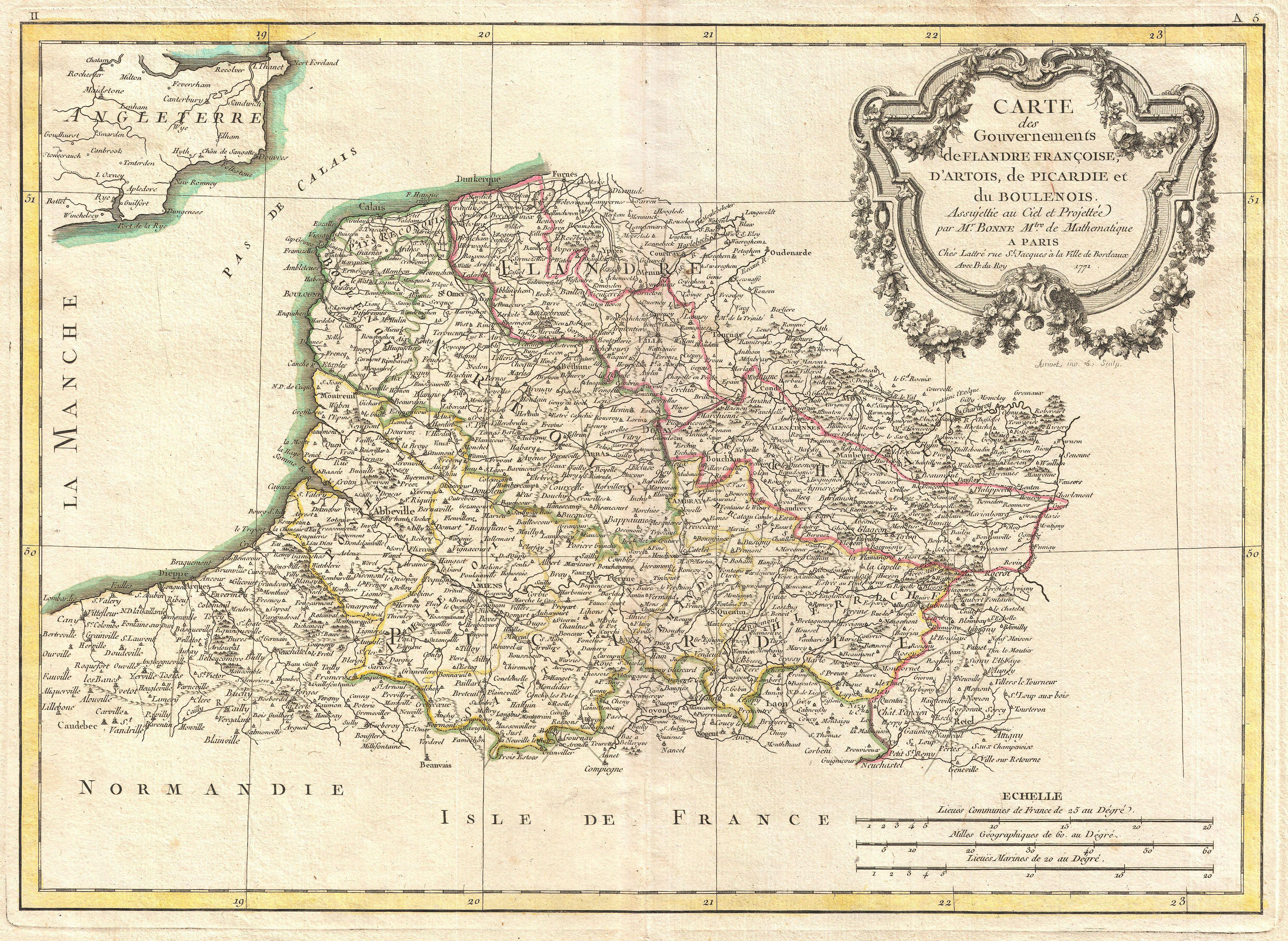
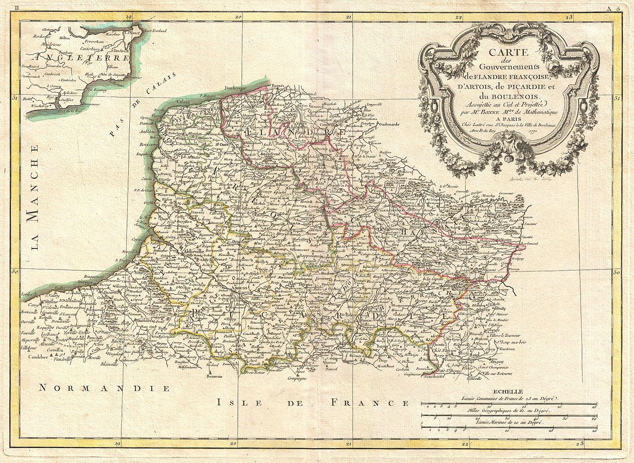
| Rigobert Bonne: Carte des Gouvernements de Flandre Françoise, d'Artois, de Picardie et du Boulenois.
( |
|||||||||||||||||||||||
|---|---|---|---|---|---|---|---|---|---|---|---|---|---|---|---|---|---|---|---|---|---|---|---|
| Artist |
|
||||||||||||||||||||||
| Title |
Carte des Gouvernements de Flandre Françoise, d'Artois, de Picardie et du Boulenois. |
||||||||||||||||||||||
| Description |
English: A beautiful example of Rigobert Bonne's decorative map of the French regions of Picardy, Artois, and French Flanders. Covers the region in full from the English Chanel to Normandy. large decorative title cartouche appears in the upper right quadrant. Drawn by R. Bonne in 1771 for issue as plate no. A 5 in Jean Lattre's 1776 issue of the Atlas Moderne . |
||||||||||||||||||||||
| Date | 1771 (dated) | ||||||||||||||||||||||
| Dimensions | height: 12 in (30.4 cm); width: 16.5 in (41.9 cm) | ||||||||||||||||||||||
| Accession number |
Geographicus link: Picardie-bonne-1771 |
||||||||||||||||||||||
| Source/Photographer |
Lattre, Jean, Atlas Moderne ou Collection de Cartes sur Toutes les Parties du Globe Terrestre, c. 1775.
|
||||||||||||||||||||||
| Permission (Reusing this file) |
|
||||||||||||||||||||||
| Other versions | |||||||||||||||||||||||

File history
Click on a date/time to view the file as it appeared at that time.
| Date/Time | Thumbnail | Dimensions | User | Comment | |
|---|---|---|---|---|---|
| current | 18:21, 23 March 2011 | | 3,500 × 2,558 (2.6 MB) | BotMultichillT (talk | contribs) | {{subst:User:Multichill/Geographicus |link=http://www.geographicus.com/P/AntiqueMap/Picardie-bonne-1771 |product_name=1771 Bonne Map of Picardy, Artois and French Flanders, France |map_title=Carte des Gouvernements de Flandre Francoise, d'Artois, de Picar |
You cannot overwrite this file.
File usage on Commons
The following 2 pages use this file:
File usage on other wikis
The following other wikis use this file:
- Usage on fr.wikipedia.org