File:1719 Asia - A new and correct map of the whole world, shewing ye situation of its principal parts. ... according to the newest and most exact observations - by Herman Moll, geographer, 1719. NYPL1630430 (cropped).tiff
Jump to navigation
Jump to search

Size of this JPG preview of this TIF file: 800 × 599 pixels. Other resolutions: 320 × 240 pixels | 640 × 480 pixels | 1,024 × 767 pixels | 1,280 × 959 pixels | 2,018 × 1,512 pixels.
Original file (2,018 × 1,512 pixels, file size: 8.76 MB, MIME type: image/tiff)
Captions
Captions
Add a one-line explanation of what this file represents
Summary
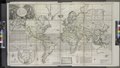
[edit]| Description | A new and correct map of the whole world, shewing ye situation of its principal parts. ... according to the newest and most exact observations / by Herman Moll, geographer, 1719.; Lawrence H. Slaughter Collection of English maps, charts, globes, books and atlases / Atlases / The world described, or, A new and correct sett of maps : shewing the kingdoms and states in all the known parts of the earth, with the principal cities, and most considerable towns in the world ... / ... by Herman Moll, geographer ... | |||||||||||||||||||||||
| Notes | To His most sacred Majesty George II, ... King of Great Britain, France and Ireland ... this map is humbly dedicated. | |||||||||||||||||||||||
| Catalogue call number | Map Div. 97-6053[LHS 329; atlas cases] | |||||||||||||||||||||||
| Item/Page/Plate | 2 | |||||||||||||||||||||||
| Standard reference | Variant of Phillips 554 | |||||||||||||||||||||||
| Date | ||||||||||||||||||||||||
| Source |
http://digitalgallery.nypl.org/nypldigital/dgkeysearchdetail.cfm?imageID=1630430
|
|||||||||||||||||||||||
| Author | Bowles, Thomas, 1694-1773 -- Bookseller; Moll, Herman, d. 1732 -- Cartographer | |||||||||||||||||||||||
| Permission (Reusing this file) |
From The Lionel Pincus and Princess Firyal Map Division. http://maps.nypl.org
|
|||||||||||||||||||||||
| Other versions |
|
|||||||||||||||||||||||
| Source description | 1 atlas (65 leaves (most folded)) : 31 maps (most hand col.) ; 65 cm. | |||||||||||||||||||||||
| Location | Stephen A. Schwarzman Building / The Lionel Pincus and Princess Firyal Map Division | |||||||||||||||||||||||
| Digital item published | 5-12-2008; updated 1-9-2012 | |||||||||||||||||||||||
| Digital ID | 1630430 | |||||||||||||||||||||||

The making of this file was supported by Wikimedia UK.
To see other files made with the support of Wikimedia UK, please see the category Supported by Wikimedia UK.
|
File history
Click on a date/time to view the file as it appeared at that time.
| Date/Time | Thumbnail | Dimensions | User | Comment | |
|---|---|---|---|---|---|
| current | 22:35, 17 January 2022 |  | 2,018 × 1,512 (8.76 MB) | Ooligan (talk | contribs) | File:A new and correct map of the whole world, shewing ye situation of its principal parts. ... according to the newest and most exact observations - by Herman Moll, geographer, 1719. NYPL1630430.tiff cropped 79 % horizontally, 72 % vertically using CropTool with precise mode. |
You cannot overwrite this file.
File usage on Commons
The following 2 pages use this file:
Metadata
Categories:
- Map images supported by Wikimedia UK
- 1719 maps of Asia
- 1710s maps of China
- 18th-century maps of Tibet
- 18th-century maps of South Asia
- 18th-century maps of Southeast Asia
- 18th-century maps of Mongolia
- A New and Correct Map of the Whole World (Moll)
- 18th-century maps of the Malay Archipelago
- Sea of Japan naming dispute