File:16-09-29-Bahnhof Calau-RR2 6548.jpg
![File:16-09-29-Bahnhof Calau-RR2 6548.jpg](https://upload.wikimedia.org/wikipedia/commons/thumb/4/48/16-09-29-Bahnhof_Calau-RR2_6548.jpg/800px-16-09-29-Bahnhof_Calau-RR2_6548.jpg?20161003165049)
Original file (4,288 × 2,848 pixels, file size: 7.5 MB, MIME type: image/jpeg)
Captions
Captions
Summary
[edit]Description16-09-29-Bahnhof Calau-RR2 6548.jpg |
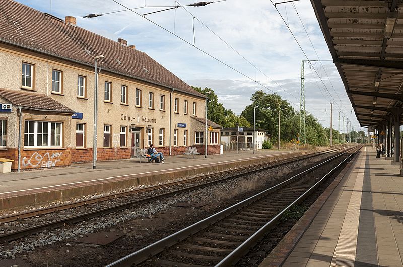
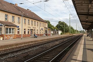
Deutsch: Bahnhof Calau |
|||||||||||||||||||||||
Date | ||||||||||||||||||||||||
Source | Own work | |||||||||||||||||||||||
Author |
creator QS:P170,Q15080600
|
|||||||||||||||||||||||
Permission (Reusing this file) |
|
Camera location | 51° 44′ 16.56″ N, 13° 58′ 45.6″ E ![]() | View this and other nearby images on: OpenStreetMap | ![]() |
---|
Licensing
[edit]![]() |
Permission is granted to copy, distribute and/or modify this document under the terms of the GNU Free Documentation License, Version 1.2 only as published by the Free Software Foundation; with no Invariant Sections, no Front-Cover Texts, and no Back-Cover Texts. A copy of the license is included in the section entitled GNU Free Documentation License. | 1.2 onlyhttp://www.gnu.org/licenses/old-licenses/fdl-1.2.htmlGFDL 1.2GNU Free Documentation License 1.2truetrue |
Annotations InfoField | This image is annotated: View the annotations at Commons |
Dust spot.
![]() |
This image has been assessed using the Quality image guidelines and is considered a Quality image.
العربية ∙ جازايرية ∙ беларуская ∙ беларуская (тарашкевіца) ∙ български ∙ বাংলা ∙ català ∙ čeština ∙ Cymraeg ∙ Deutsch ∙ Schweizer Hochdeutsch ∙ Zazaki ∙ Ελληνικά ∙ English ∙ Esperanto ∙ español ∙ eesti ∙ euskara ∙ فارسی ∙ suomi ∙ français ∙ galego ∙ עברית ∙ हिन्दी ∙ hrvatski ∙ magyar ∙ հայերեն ∙ Bahasa Indonesia ∙ italiano ∙ 日本語 ∙ Jawa ∙ ქართული ∙ 한국어 ∙ kurdî ∙ Lëtzebuergesch ∙ lietuvių ∙ македонски ∙ മലയാളം ∙ मराठी ∙ Bahasa Melayu ∙ Nederlands ∙ Norfuk / Pitkern ∙ polski ∙ português ∙ português do Brasil ∙ rumantsch ∙ română ∙ русский ∙ sicilianu ∙ slovenčina ∙ slovenščina ∙ shqip ∙ српски / srpski ∙ svenska ∙ தமிழ் ∙ తెలుగు ∙ ไทย ∙ Tagalog ∙ Türkçe ∙ toki pona ∙ українська ∙ vèneto ∙ Tiếng Việt ∙ 中文 ∙ 中文(简体) ∙ 中文(繁體) ∙ +/− |
File history
Click on a date/time to view the file as it appeared at that time.
Date/Time | Thumbnail | Dimensions | User | Comment | |
---|---|---|---|---|---|
current | 16:50, 3 October 2016 | ![]() | 4,288 × 2,848 (7.5 MB) | Ralf Roletschek (talk | contribs) |
You cannot overwrite this file.
File usage on Commons
The following 7 pages use this file:
- User:Ralf Roletschek/gallery/2017-1
- User:Ralf Roletschek/qic
- User:Z thomas/OSL/2016 October
- Commons:Quality images/Subject/Architecture/Transport Infrastructure/Other/Archive 2015 to 2017
- Commons:Quality images candidates/Archives November 01 2016
- Commons:Quality images candidates/Archives October 26 2016
- Category:Bahnhof Calau
File usage on other wikis
The following other wikis use this file:
- Usage on de.wikipedia.org
- Usage on de.wikivoyage.org
- Usage on en.wikipedia.org
- Usage on www.wikidata.org
Metadata
This file contains additional information such as Exif metadata which may have been added by the digital camera, scanner, or software program used to create or digitize it. If the file has been modified from its original state, some details such as the timestamp may not fully reflect those of the original file. The timestamp is only as accurate as the clock in the camera, and it may be completely wrong.
Camera manufacturer | NIKON CORPORATION |
---|---|
Camera model | NIKON D300S |
Author | Ralf Roletschek |
Exposure time | 1/400 sec (0.0025) |
F-number | f/10 |
ISO speed rating | 200 |
Date and time of data generation | 12:17, 29 September 2016 |
Lens focal length | 24 mm |
User comments | urheberrechtlich geschuetzt |
Latitude | 51° 44′ 16.55″ N |
Longitude | 13° 58′ 45.59″ E |
Altitude | 100 meters above sea level |
Copyright holder |
|
Usage terms |
|
Horizontal resolution | 300 dpi |
Vertical resolution | 300 dpi |
Software used | Adobe Photoshop Camera Raw 9.6.1 (Windows) |
File change date and time | 18:46, 3 October 2016 |
Exposure Program | Normal program |
Exif version | 2.3 |
Date and time of digitizing | 12:17, 29 September 2016 |
APEX shutter speed | 8.643856 |
APEX aperture | 6.643856 |
APEX exposure bias | 0 |
Maximum land aperture | 3 APEX (f/2.83) |
Metering mode | Center weighted average |
Light source | Cloudy weather |
Flash | Flash did not fire |
DateTimeOriginal subseconds | 16 |
DateTimeDigitized subseconds | 16 |
Color space | Uncalibrated |
Sensing method | One-chip color area sensor |
File source | Digital still camera |
Scene type | A directly photographed image |
Custom image processing | Normal process |
Exposure mode | Auto exposure |
White balance | Manual white balance |
Digital zoom ratio | 1 |
Focal length in 35 mm film | 36 mm |
Scene capture type | Standard |
Scene control | None |
Contrast | Normal |
Saturation | Normal |
Sharpness | Normal |
Subject distance range | Unknown |
GPS time (atomic clock) | 10:18 |
Satellites used for measurement | 04 |
Geodetic survey data used | WGS84 |
GPS date | 29 September 2016 |
GPS tag version | 0.0.2.2 |
Serial number of camera | 6092375 |
Lens used | 24.0-70.0 mm f/2.8 |
Pair of black and white reference values |
|
Date metadata was last modified | 20:46, 3 October 2016 |
Unique ID of original document | DAF8C08D26B786938C8B51C8A3C85132 |
Contact information | ralf@roletschek.de
|
IIM version | 4 |