File:1051 Great Western Road (geograph 7389795).jpg
Jump to navigation
Jump to search
Size of this preview: 800 × 600 pixels. Other resolutions: 320 × 240 pixels | 640 × 480 pixels | 1,024 × 767 pixels | 1,280 × 959 pixels | 1,600 × 1,199 pixels.
Original file (1,600 × 1,199 pixels, file size: 429 KB, MIME type: image/jpeg)
Captions
Captions
Add a one-line explanation of what this file represents
Summary
[edit].jpg&action=edit§ion=1)
| Description |
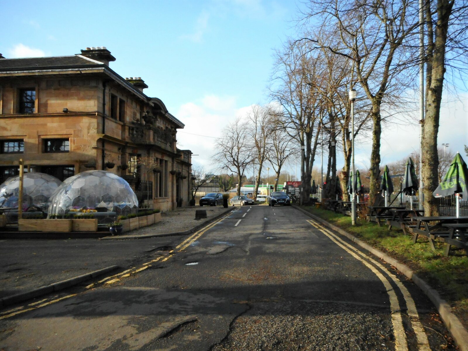
English: 1051 Great Western Road Former Kelvinside Railway Station, built by the Lanarkshire and Dumbartonshire Railway in 1897. The line ran under the station building and under Great Western Road. The station closed in 1942, but the line was used for freight traffic until 1966. The building suffered a fire in 1980, but was restored and converted into a restaurant, 'Carriages', which opened in 1983. There was another fire in 1995 and the building was gutted. After rebuilding a few years later, the restaurant reopened as 'Stazione' and 'Lux'. It has been 1051 GWR, since 2015. The domes are all-weather private hire spaces. Each dome seats up to eight people for a meal or up to 12 for drinks only. The building is Category B listed |
| Date | |
| Source | From geograph.org.uk |
| Author | Richard Sutcliffe |
| Permission (Reusing this file) |
Creative Commons Attribution Share-alike license 2.0 |
| Attribution (required by the license) | Richard Sutcliffe / 1051 Great Western Road / |
| Camera location | | View this and other nearby images on: OpenStreetMap |
|---|
.jpg¶ms=055.884173_N_-004.309015_E_globe:Earth_type:camera_source:geograph-osgb36(NS55676808)_heading:292.00&language=en)
| Object location | | View this and other nearby images on: OpenStreetMap |
|---|
.jpg¶ms=055.884250_N_-004.309500_E_globe:Earth_class:object_type:object_source:geograph-osgb36(NS55646809)_heading:292.00&language=en)
Licensing
[edit].jpg&action=edit§ion=2)

|
This image was taken from the Geograph project collection. See this photograph's page on the Geograph website for the photographer's contact details. The copyright on this image is owned by Richard Sutcliffe and is licensed for reuse under the Creative Commons Attribution-ShareAlike 2.0 license.
|
This file is licensed under the Creative Commons Attribution-Share Alike 2.0 Generic license.
Attribution: Richard Sutcliffe
- You are free:
- to share – to copy, distribute and transmit the work
- to remix – to adapt the work
- Under the following conditions:
- attribution – You must give appropriate credit, provide a link to the license, and indicate if changes were made. You may do so in any reasonable manner, but not in any way that suggests the licensor endorses you or your use.
- share alike – If you remix, transform, or build upon the material, you must distribute your contributions under the same or compatible license as the original.
File history
Click on a date/time to view the file as it appeared at that time.
| Date/Time | Thumbnail | Dimensions | User | Comment | |
|---|---|---|---|---|---|
| current | 19:40, 18 November 2023 | | 1,600 × 1,199 (429 KB) | Lamberhurst (talk | contribs) | == {{int:filedesc}} == {{Information |Description={{en|1=<b>1051 Great Western Road</b><br>Former Kelvinside Railway Station, built by the Lanarkshire and Dumbartonshire Railway in 1897. The line ran under the station building and under Great Western Road. The station closed in 1942, but the line was used for freight traffic until 1966. The building suffered a fire in 1980, but was restored and converted into a restaurant, 'Carriages', which opened in 1983. There was another fire in 1995 and... |
You cannot overwrite this file.
File usage on Commons
The following page uses this file:
.jpg&oldid=877329665)