File:(North Carolina LOC 99447452.jpg
Jump to navigation
Jump to search

Size of this preview: 800 × 369 pixels. Other resolutions: 320 × 148 pixels | 640 × 295 pixels | 1,024 × 473 pixels | 1,280 × 591 pixels | 2,560 × 1,182 pixels | 9,173 × 4,235 pixels.
Original file (9,173 × 4,235 pixels, file size: 9.71 MB, MIME type: image/jpeg)
Captions
Captions
Add a one-line explanation of what this file represents
Summary
[edit]| Description |
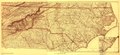
English: Scale ca. 1:950,000 (not "1 inch = 10 miles"). LC Civil War Maps (2nd ed.), 305a.5 Reduced facsimile from William P. Cumming's North Carolina in Maps (Raleigh, State Department of Archives and History, 1966) plate XIII. Printed in brown ink. This facsimile was produced from a composite map in the State Department of Archives and History, Raleigh, N.C. The composite was made up from Lindenkohl's map of "[Eastern Tennessee, with parts of Alabama, Georgia, South Carolina, North Carolina, Virginia, and Kentucky]" (entry no. 75.8) and his "[North Carolina, with adjacent parts of Virginia and South Carolina]" (entry no. 305a.6). Description derived from published bibliography. Available also through the Library of Congress web site as raster image. |
||
| Title | [North Carolina | ||
| Shelf ID | G3900 1865 .L5 1966 | ||
| Date | |||
| Source | https://www.loc.gov/item/99447452/ | ||
| Author | Lindenkohl, A.; United States Coast Survey | ||
| Permission (Reusing this file) |
|
||
| Other versions |
|
||
| Location | United States · North Carolina | ||
| Part of | Military Battles And Campaigns · American Memory · Civil War Maps · Catalog · Geography And Map Division | ||
| Subject | United States · Maps · North Carolina |

Licensing
[edit]
| This work is from the Library of Congress. According to the library, there are no known copyright restrictions on the use of this work. |  |
File history
Click on a date/time to view the file as it appeared at that time.
| Date/Time | Thumbnail | Dimensions | User | Comment | |
|---|---|---|---|---|---|
| current | 00:21, 2 August 2018 | | 9,173 × 4,235 (9.71 MB) | Fæ (talk | contribs) | LOC Maps https://www.loc.gov/item/99447452/ #18964 |
You cannot overwrite this file.
File usage on Commons
The following page uses this file: